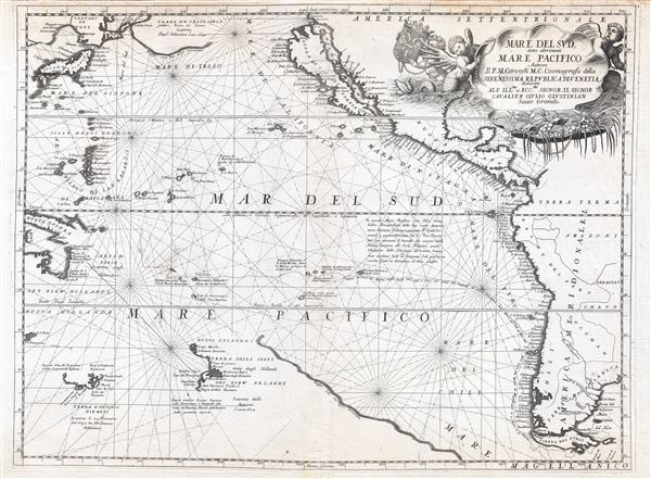
An exceptional 1691 nautically styled map of the Pacific Ocean by the Venetian cartographer Vincenzo Maria Coronelli. Coronelli's map covers the Pacific from Japan to New Zealand and from New Guinea to Tiera Del Fuego and the Yucatan. The map focuses on the new discoveries in the Pacific by Dutch, French, and Spanish, and as such is styled as nautical chart with heavy coastal but only limited inland detail. The map features much of note including a presentation of California as an Island, and illustration of a speculative Terra de Yesso (Hokkaido), and early speculative mappings of Australia, Tasmania, New Zealand, and New Guinea.
Coronelli boldly presents California in insular form on the Luke Foxe model popularized by Nicholas Sanson in 1657. Luke Foxe as an English navigator who lead a 1631 expedition in search of the Northwest Passage. Although he had no luck in his hunt, his expedition lost no lives, which is a feat for early explores in Arctic waters. The maps associated with his expedition featured a surprising illustration of California in island form. It was Foxe who is credited with introducing the curious form of northern Insular California, including the Bay of Talago, the Rio de Estiete, and the unusual peninsula extending from the mainland, Agubela de Gato. The origin of this cartography beyond Foxe remains a mystery given that Foxe himself never sailed anywhere near California.
The idea of an insular California first appeared as a work of fiction in Garci Rodriguez de Montalvo's c. 1510 romance Las Sergas de Esplandian, where he writes
Know, that on the right hand of the Indies there is an island called California very close to the side of the Terrestrial Paradise; and it is peopled by black women, without any man among them, for they live in the manner of Amazons.
Baja California was subsequently discovered in 1533 by Fortun Ximenez, who had been sent to the area by Hernan Cortez. When Cortez himself traveled to Baja, he must have had Montalvo's novel in mind, for he immediately claimed the 'Island of California' for the Spanish King. By the late 16th and early 17th century ample evidence had been amassed, through explorations of the region by Francisco de Ulloa, Hernando de Alarcon and others, that California was in fact a peninsula. However, by this time other factors were in play. Francis Drake had sailed north and claimed 'New Albion' (identified here on the northwest coast of California Island) near modern day Washington or Vancouver for England. The Spanish thus needed to promote Cortez's claim on the 'Island of California' to preempt English claims on the western coast of North America. The significant influence of the Spanish crown on European cartographers caused a major resurgence of the Insular California theory. Just before this map was made Eusebio Kino, a Jesuit missionary, traveled overland from Mexico to California, proving conclusively the peninsularity of California.
Across the Pacific Australia, New Zealand, and Tasmania are presented in very speculative form referencing the voyages of Abel Tasman. Australia is identified as both Niew Hollandt and Nuova Hollanda. Only parts of Australia's northern shore and Carpentaria are evident. Similarly, only the southern shores of Tasmania are identified. New Zealand is even more speculative and only its western shores are noted. Although a speculative landmass to the east of New Zealand - a remnant of Terra Australis, suggests that it might be connected. Coronelli incorrectly suggests that the islands were discovered in 1654.
Coronoelli further traces the 1616-1617 voyages of Jacob Le Maire and Willem Cornelisz Schouten around Tierra del Fuego and into the Pacific. This remarkable voyage was sponsored the Austraalse Compagnie, an organization founded by Isaac Le Maire, Jacob's father, in an attempt to break up the VOC monopoly on the East India trade. The goal was to find new trade routes to the Far East and in this they succeeded, charting the passage around Cape Horne (named after their lost ship, the
Hoorne). Nonetheless they were politically defeated back in Holland where the States General ruled that Austraalse Compagnie would not be permitted to trade in the Far East.
At the northern most extreme of the map we can find a large landmass extending eastward towards North America labeled 'Terra de Iesso o Ieco'. While the term Yesso typically refers to Hokkaido, here identified as Yupi, Coronelli has enlarged Yesso and moved it further east to correspond to the Islands discovered by Maerten de Vries and Cornelis Jansz Coen in 1643. The Vries-Coen expedition was launched in response to a obscure Spanish legend describing gold and silver rich islands somewhere to the east of Japan. These islands were said to be so saturated in precious metals that the tall, friendly, light skinned inhabitants even fashioned their homes out of gold. As improbable as it may seem, the idea inspired at least two expeditions to the region. Anthony Van Diemen, the director of the Dutch East India Company in the Indies, initiated an unsuccessful first expedition under Abel Jansz Tasman and Matthijs Hendricksz Quast in 1639, and a second more interesting expedition under Maerten de Vries and Cornelis Jansz Coen in 1643. It is this latter mission that most influenced the present map. The expedition followed the southeast coast of Hokkaido in a northeasterly direction where it encountered at least two of the Kuril Islands, Kunashir and Iturop, before sailing westward where the navigators correctly identified the forklike peninsulas of southern Sakhalin, but not the strait that separated them from Hokkaido. From here they again sailed south into more known waters. Vries and Coen were the first Europeans to enter these waters, which were in fact little known even to the Japanese. They made early contact with the indigenous Ainu people of Hokkaido, who they noted had silver-hilted daggers. They were the first to discover the Kuril Islands, here identified as 'Terra delgi Stati' (a variant on Staten Eyland) and 'Iesso o Ieco' (more commonly Compagniesland). 'Terra delgi Stati' is in fact a reasonable approximation of Kunashir, the westernmost of the Kuril Island, while 'Iesso o Ieco' is, according to the convention of the period, a grossly overstated speculation on Iturop.
The elaborate title cartouche in the upper right is a fine example of the beautiful engraving typical of Coronelli's work. The cartouche frames the title with a scallop shell motif. The lower half of the shell is open to reveal the bounty of the sea, including pearls and corals. Putti support the shell and hold aloft the janiform armorial crest of t Holy Roman Empire. The map is dedicated to Cavalier Giulio Giustinian.
Overall, this is one of the most beautifully produced and dramatic maps of the Pacific to appear in the 17th century. It was initially issued in the 1691 in the first edition of
Atlante Veneto and subsequently reissued in the 1695-97 edition. There is only one known state, but a small plate crack did develop just to the right of Tierra de Fuego between the 40th and 45th south latitudes. The size of the crack can be used to determine if a particular map was an early or late strike of the plate. In the present example the crack is minimal and restricted to the border, thus suggesting an early strike.
Cartographer
Vincenzo Maria Coronelli (August 16, 1650 - December 9, 1718) was an important 17th century cartographer and globe maker based in Venice. Coronelli was born the fifth child of a Venetian tailor. Unlikely to inherit his father's business, he instead apprenticed in Ravenna to a woodcut artist. Around 1663, Coronelli joined the Franciscan Order and in 1671, entered the Venetian convent of Saint Maria Gloriosa dei Frari. Coronelli excelled in the fields of cosmography, mathematics, and geography. Although his works include the phenomenal Atlante Veneto and Corso Geografico, Coronelli is best known for his globes. In 1678 Coronelli was commissioned to make his first major globes by Ranuccio II Farnese, Duke of Parma. Each superbly engraved globe was five feet in diameter. Louis IV of France, having heard of the magnificent Parma globes, invited Coronelli to Paris where he constructed an even more impressive pair of gigantic globes measuring over 12 feet in diameter and weighing 2 tons each. Coronelli returned to Venice and continued to published globes, maps, and atlases which were admired all over Europe for their beauty, accuracy, and detail. He had a particular fascination for the Great Lakes region and his early maps of this area were unsurpassed in accuracy for nearly 100 years after their initial publication. He is also well known for his groundbreaking publication of the first accurate map depicting the sources of the Blue Nile. At the height of his career, Coronelli founded the world's first geographical society, the Accademia Cosmografica degli Argonauti and was awarded the official title Cosmographer of the Republic of Venice. In 1699, in recognition of his extraordinary accomplishment and scholarship, Coronelli was also appointed Father General of the Franciscan Order. The great cartographer and globe maker died in Venice at the age of 68. His extraordinary globes can be seen today at the Bibliothèque Nationale François Mitterrand in Paris, Biblioteca Marciana in Venice, in the National Library of Austria and in the Globe Museum in Vienna, in the library of Stift Melk, in the Special Collections Library of Texas Tech University, as well as lesser works in Trier, Prague, London, and Washington D.C. Coronelli's work is notable for its distinctive style, which is characterized by high quality white paper, dark intense impressions, detailed renderings of topographical features in profile, and numerous cartographic innovations. More by this mapmaker...
Source
Coronelli, Vincento. Atlante Veneto, (Venice) 1691, 1st edition.
The Atlante Veneto was a Venetian cosmographic atlas issued by the Jesuit Minorite friar, geographer, and globe maker Vincenzo Maria Coronelli. The Atlante Veneto was a massive work consisting of some 13 volumes in four parts. The first section focused on a general introduction to geography and included notes a various geographic systems and globes. The second part consisted of world maps from various periods and in various styles, including double page maps of the continents and poles derived from his earlier globe work. The third part focused on hydrography and included nautically styled maps of important rivers, bays, oceans, lakes, and gulfs. The fourth and final section detailed exploration and describing noting various explorers and their discoveries. The whole consisted of some 191 engraved charts and maps as well as an assortment of views and decorative plates. The atlas was conceived as a continuation of Blaeu's Atlas Major and in many respects follows Blaeu cartographically. Many of the other maps are derived from Coronelli's own earlier globe work and exhibit various distinctly globe-like elements. Coronelli first issued the Atlante Veneto in 1691. A second edition was prepared and issued between 1695 and 1697. Most of the individual map plates remain identical between editions. The maps of the Atlante Veneto are universally admired for their exquisite engraving and high production quality, including fine paper and premium inks. All examples were issued uncolored and have typically been left as such by dealers and collectors.
Very good. Minor marginal toning. Platemark visible. Blank on verso. Original centerfold.