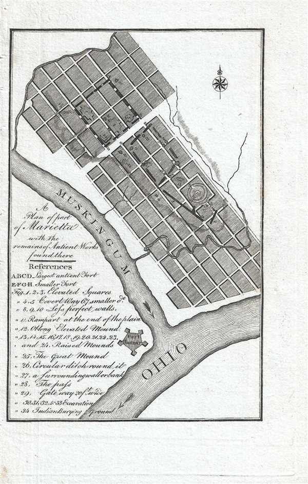
This is an 1805 Thaddeus Mason Harris map of part of the town of Marietta, Ohio, the first permanent United States settlement in the Northwest Territory. The map depicts the town of Marietta from the Muskingum River to east of town and from just north of town to the Ohio River. By illustrating the general layout of the part of the city where the Earthworks are located, an idea of how the Earthworks fit within the city grid is presented. Two forts, ABCD and EFGH are labeled, ABCD being the larger of the two, along with 34 locations throughout Marietta which are identified numerically. Fort Harmer is also labeled, and is situated at the confluence of the Muskingum and Ohio Rivers.
Marietta was founded in 1788 by Rufus Putnam, one of the founders of The Ohio Company, which was created to facilitate the settlement of the modern day state of Ohio through the sale of land. According to Harris
Marietta is a place of much business ; and is rapidly increasing in population, wealth, and elegance. Ship-building is already carried on to a considerate extent. A spirit of industry and enterprize prevails. Add to all, the remarkable healthiness of the place, the benefit it receives from the growing settlements upon the Muskingum, and the extensive navigation of that river ; and it is easy to foresee that it will maintain a character as the most respectable and thriving town in the state
This map was published by Thaddeus Mason Harris in his book
The Journal of a Tour into the Territory Northwest of the Alleghany Mountains... in 1805.
Cartographer
Thaddeus Mason Harris (July 7, 1768 - April 3, 1842) was a Harvard librarian, Unitarian minister and author. He was born in Charlestown, Massachusetts. After his father’s death while fighting on the colonial side in the American Revolutionary War, Harris was sent to live on a farm in Sterling, Massachusetts. Harris studied at Harvard University and graduated in 1787. Following his graduation, Harris spent a year as a school teacher in Worcester, Massachusetts, after which he was offered an appointment as secretary to George Washington. Unfortunately he contracted small-pox, and his lengthly recovery prevented him from taking the post. In 1791, Harris became the librarian at Harvard and was appointed as the minister of the First Unitarian Church on Meeting House Hill in Dorchester, Massachusetts, in 1793. In 1806, he was elected as a Fellow of the American Academy of Arts and Sciences and was also a founding member of the American Antiquarian Society in 1812. He served as corresponding secretary for the Antiquarian Society from 1812-1831, and as secretary of foreign correspondence from 1831-1832. More by this mapmaker...
Source
Harris, T.M., The Journal of a Tour into the Territory Northwest of the Alleghany Mountains; Made in the Spring of the Year 1803. With a Geographical and Historical Account of the State of Ohio., (Boston: Manning and Loring) 1805.
The Journal of a Tour into the Territory Northwest of the Alleghany Mountains; Made in the Spring of the Year 1803. With a Geographical and Historical Account of the State of Ohio. by Thaddeus Mason Harris, published in 1805, presents a history of Harris’s journey to Marietta, Ohio. The first section of the book consists of Harris’s journal, which is divided into two sections: the trip to Marietta, and the return trip to Boston. The second section, entitled, ‘Geographical and Historical Account of the State of Ohio’, was compiled by Harris. It includes a discussion of the state’s boundaries, its climate, minerals, rivers, fish, counties and towns, exports, antiquities, ‘curiosities’, government and history. In the chapter discussing Ohio’s history, a lengthy discussion of the Ohio Company is included. The final section is an appendix, which includes information about navigating the Ohio River and reprinted versions of a number of documents concerning the early history of Ohio, including the 1785 Land Ordinance, the contract between the Ohio Company and the U.S. Government for the sale of millions of acres of land (1787), the Northwest Ordinance (1787), the Congressional act enabling the establishment of Ohio (1802) and the Ohio Constitution (1802).
Very good. Blank on verso.