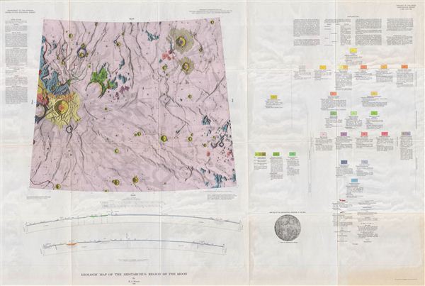
This is the U.S. Geological Survey's stunning full color geologic map of the Moon's fascinating and mysterious Aristarchus region. Deep in the dark expanse of the Ocean of Storms ('Oceanus Procellarum'), sits Aristarchus Plateau, pocked by Aristarchus Crater, the brightest large formation on the moon, visible to the naked eye on the northwest (or upper left) of the Moon's near side.
This mysterious region is the site of more ‘transient lunar phenomena' than any other on the Moon. Transient lunar phenomena are temporary obscurations, explosions, or color changes on the surface. And then there was the event of 1971. Apollo 15 was passing 110 kilometers above the plateau, when Aristarchus emited a burst of radioactive Radon-222 alpha particles. Selenologists say this was either a coincidental diffusion of gas to the surface, or a discrete explosion. An explosion leaves those with a taste in science fiction (which so often becomes science fact) to wonder: was something under the surface of the Moon attempting to communicate? Or destroy?
Fittingly, this map's rich, veiny colors suggest a fleshy, alien landscape. The map includes two sectional views (from the side) of the area, detailed ‘metadata' explaining the mapmaking methodologies and symbols employed, and an index map showing the area's location on the Moon.
Aristarchus was named after the Greek astronomer Aristarchus of Samos (310-c.230 BC), creator of the first known helio-centric model of the solar system, placing the Sun, not the earth, at the center of the solar system. The crater was so named by the Italian map maker Giovanni Riccioli in his 1651, The New Algamest,, in which he named craters after famous astronomers and philosophers. The name became an international standard when it was adopted by the IAU (International Astronomical Union) in 1935.
It is believed that most of the moon's craters were formed approximately 3.9 billion years ago, during a period of intense bombardment in the Inner Solar System. The cratering rate fluctuates as collisions in the asteroid belt send fragment clusters into the Inner Solar System. This map might show hypervelocity impact craters caused by the same cluster of asteroids that, 65 million years ago, caused the extinction of the dinosaurs.
As humans wouldn't land on the moon until 1969, how were we able to map its geology? The map's extraordinarily detailed metadata explains that the cartographers used photos dating back to 1960 (remember the series of Ranger missions in the mid-60's?), and observations from optical and radio telescopes, with relief created by measuring shadows, combined with an assumed sun angle and an assumed base elevation. The geology was arrived at from observing differences in, and layering of, topographical forms, and in varying albedo (amount of reflected sunlight), both of which indicate different underlying materials formed under different processes. Goals of this work included the identification of suitable moon landing locations, and sources of oxygen for possible in establishing a more permanent lunar base.
This map represents a breath-taking leap forward not only in selenography (the study of the moon), begun in the late 1400s, but also in the record of humankind's fearless exploration of the world(s) around and beyond us.
This map would be a great companion piece to the other maps in the Geologic Atlas of the Moon,. It would also wonderfully complement early explorers' maps, or any of the plates from Burritt's famous 1856 Atlas to Illustrate the Geography of the Heavens , one of writer H.P. Lovecraft's most prized possessions.
Created by H.J. Moore and published as plate I-465 in the United States Geological Survey's Geological Atlas of the Moon.
Cartographer
The Office of the Coast Survey (later the U.S. Geodetic Survey) (1807 - present), founded in 1807 by President Thomas Jefferson and Secretary of Commerce Albert Gallatin, is the oldest scientific organization in the U.S. Federal Government. Jefferson created the "Survey of the Coast," as it was then called, in response to a need for accurate navigational charts of the new nation's coasts and harbors. The first superintendent of the Coast Survey was Swiss immigrant and West Point mathematics professor Ferdinand Hassler. Under the direction of Hassler, from 1816 to 1843, the ideological and scientific foundations for the Coast Survey were established. Hassler, and the Coast Survey under him developed a reputation for uncompromising dedication to the principles of accuracy and excellence. Hassler lead the Coast Survey until his death in 1843, at which time Alexander Dallas Bache, a great-grandson of Benjamin Franklin, took the helm. Under the leadership A. D. Bache, the Coast Survey did most of its most important work. During his Superintendence, from 1843 to 1865, Bache was steadfast advocate of American science and navigation and in fact founded the American Academy of Sciences. Bache was succeeded by Benjamin Pierce who ran the Survey from 1867 to 1874. Pierce was in turn succeeded by Carlile Pollock Patterson who was Superintendent from 1874 to 1881. In 1878, under Patterson's superintendence, the U.S. Coast Survey was reorganized as the U.S. Coast and Geodetic Survey (C & GS or USGS) to accommodate topographic as well as nautical surveys. Today the Coast Survey is part of the National Oceanic and Atmospheric Administration or NOAA. More by this mapmaker...
Source
Geologic Atlas of the Moon. Department of Interior. US Geological Survey
Very Good.