Title
Route of the Mormon Pioneers from Nauvoo to Great Salt Lake.
1899 (dated)
14 x 41.5 in (35.56 x 105.41 cm)
1 : 67905000
Description
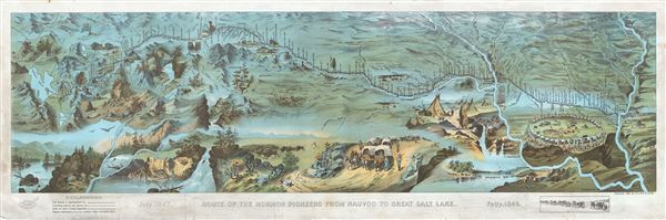
This is an extraordinary and striking 1899 chromolithograph panoramic bird-eye view and map of the 1,300 mile Mormon Trail. This view, by Millroy and Hayes, covers the region between the Mississippi River and Great Salt Lake and chronicles the westward migration of the Mormon Pioneers from Nauvoo, Illinois to Great Salt Lake, Utah, 1846-1847. It details part of the modern day states of Iowa, Nebraska, Wyoming, and Utah. The day to day progression of the pioneers is noted and the whole is surrounded by dramatic vignettes illustrating wagon trains, circled wagons at night, Indian Tepees, the Mormon Battalion, and other western scenery. The map and events depicted are derived from the journals of Orson Pratt and his brother Parley P. Pratt, original members of the 'Quorum of Twelve Apostles'.
The Mormon Trail extends from Nauvoo, Illinois, which was the principal settlement of the Latter Day Saints from 1839 to 1846, to Salt Lake City, Utah, which was settled by Brigham Young and his followers beginning in 1847. From 1838 to 1846 most Mormons had settled in Nauvoo, Illinois under the leadership of Bingham Young. Tensions between the newly arrived Mormons and established Nauvoo residents led to the eviction of Mormons from the region. The Quincy Convention of 1845 demand that all Mormons withdraw from Nauvoo by 1846. Consulting trappers and frontiersmen, Brigham Young settled on Great Salt Lake, then part of Mexico, as their final settlement.
The trek westward began on February 4 of 1846. After crossing the Mississippi River at Nauvoo, the journey passed through Iowa Territory following early explorer's routes and Native American paths. The actual trip across was slowed by rain, mud, swollen rivers, poor preparation. Heavy rains turned the rolling plains of southern Iowa into a quagmire of axle-deep mud. Furthermore, few people carried adequate provisions. The weather, general unpreparedness, and lack of experience in moving such a large group contributed to the extreme hardship for which this voyage is known. The Latter-day Saints wintered on the Missouri River, at a camp called 'Winter Quarters', before pressing on to Fort Laramie. From Laramie the pioneers began the arduous ascent to South Pass where the crossed the Rocky Mountains and ultimately descended into the Great Basin. They arrived at Great Salt Lake in July of 1847. One year later, in 1848, at the end of the Mexican-American War, the Great Basin, and indeed the entirety of the American West, was ceded to the United States in the Treaty of Guadeloupe-Hidalgo.
There are two known editions of this view map, small and large, both of which have become extremely rare. The present example, published by Millroy and Hayes in 1899, corresponds to the larger example. Most known issues of the larger print were prepared in folding format and were accompanied by a 31 page booklet entitled Guide to the route map of the Mormon pioneers from Nauvoo to Great Salt Lake, 1846-1847. The present offering, however, is a large format presentation issue that was clearly never folded. It is printed on heavy stock without an accompanying booklet. The second issue, about 1/3 the size of this first edition, was prepared by the New Wilson European Hotel and issued later in 1899.
Cartographer
Millroy and Hayes (fl. c. 1899) were Salt Lake City based printers active in the late 19th century. They are best known for their panoramic birds-eye view illustrating the route of the Mormon Pioneers. No other publications by this firm have been recorded. More by this mapmaker...
Condition
Very good. Minor edge wear. Presentation copy on thick stock