This copy is copyright protected.
Copyright © 2024 Geographicus Rare Antique Maps
1828 Gordon Wall Map of New Jersey (first official map of New Jersey)
NewJersey-gordon-1828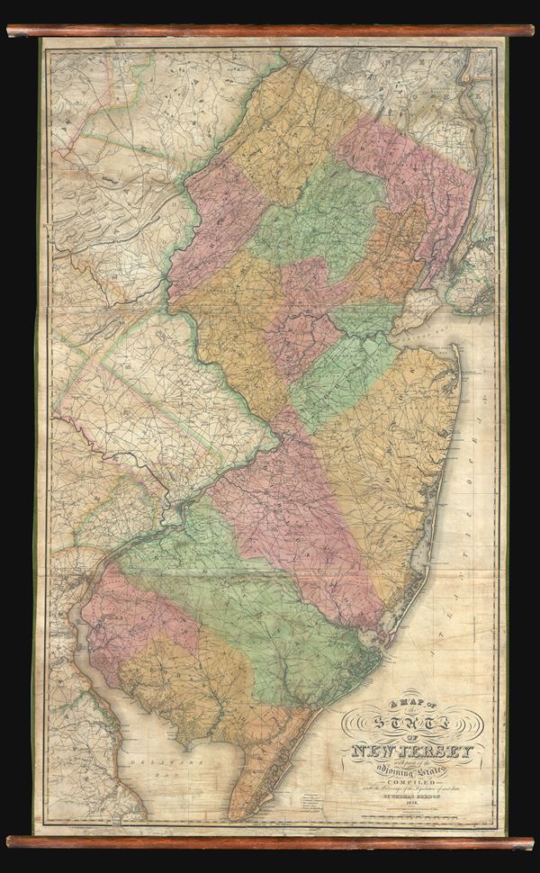

This portion of my map [New Jersey], as well as the adjoining part of New York and Pennsylvania, is rom the able and scientific map of Thomas Gordon, which is projected and drawn on a scale of three miles to an inch, and is exceedingly minute and particular. This admirable map, which must have cost its author much time and money, was compiled partly from surveys made by Mr. Gordon, combined with others collected by him during the progress of his work and published in 1828.The map thus proved a great success. Over the next several years the legislature acquired some 250 copies, which were distributed to government offices throughout the state. This would not have been sufficient on its own to support the manufacture of the map, so Gorden placed a prospectus advertisement in the July to December1827 edition of The Port Folio, Vol II of Hall's Second Series, at page 158-159, which states:
Thomas Gordon, Esq. of Trenton, proposes to publish by subscription, an accurate map of the state of New Jersey, with part of the adjoining states; this map is compiled from original materials, procured from the most authentic sources, and where these failed, they have been supplied by actual surveys, so that no reasonable expense or pains have been spared to render this map acceptable to the public. It is projected on a scale of three miles to an inch, forming a map of thirty-three by fifty-seven inches, on which is exhibited all the counties and townships in the state, with the waters, canals, roads, cities, towns, churches, mills, mountains, &e. in the most conspicuous manner; this work is now in the hands of a very skilful map engraver, and will be issued in October next.It is unclear how many private buyers Gordon was able to solicit from this advertisement.
Thomas Gordon (September 23, 1778 - 1848) was a Trenton-based judge, lawyer, surveyor and cartographer. Gordon was born in Amwell New Jersey and relocated as a young man to the larger city of Trenton. He studied law and mathematics and subsequently set up practices, as was not uncommon at the time, in both law and surveying. He is best known in cartographic circles for his production of an impressive wall map of New Jersey - the first government sponsored state map of that state. Gordon died and was buried in Trenton, New Jersey. More by this mapmaker...
Henry Schenck Tanner (1786 - May 18, 1858) was one of the preeminent American map engravers and publishers of the early 19th century - what is considered to be the "Golden Age of American Map Publishing". Born in New York City but based in Philadelphia, Tanner's forty plus year career was almost entirely focused on cartographic work. His earliest map work appears in conjunction with another important map publisher, John Melish. Early in his career, Tanner partnered with his brother Benjamin, to engrave extensively for Melish as well as other Philadelphia publishers including Lucas Fielding (Baltimore), A. Bourne, Jason Torey, Samuel Harrison, and Samuel Lewis, among others. In 1818 Tanner convinced his fellow publishers and partners to finance the compilation of a New American Atlas. The atlas was sold by subscription and slowly emerged between 1819 and 1823. The New American Atlas, possibly the pinnacle of 19th century American cartography and was commended in its day as "one of the most splendid works of the kind ever executed in this country". It was subsequently republished in several updated editions until about 1839. Tanner had by this time become the most active and influential map publisher in the United States. Around 1832, recognizing the market for a less cost prohibitive atlas, Tanner began work on the smaller format New Universal Atlas. This popular and important atlas went through numerous editions before being bought out by Carey and Hart, and then, in 1846, by S. A. Mitchell, who would rise to become the preeminent publisher of the next generation. In addition to these important atlases, Tanner also issued numerous extremely important and influential travelers guides, state maps, wall maps, and pocket maps. He should not be confused with his brother, also an America map engraver, the New Yorker Benjamin Tanner. Learn More...
Copyright © 2024 Geographicus Rare Antique Maps | Geographicus Rare Antique Maps
This copy is copyright protected.
Copyright © 2024 Geographicus Rare Antique Maps