This item has been sold, but you can get on the Waitlist to be notified if another example becomes available, or purchase a digital scan.

1870 Knapp Map of Northern Manhattan ( New York City )

NewYorkNorth155-knapp-1870
$375.00
Map of that Part of the City of New York North of 155th Street Showing the progress made in laying out Streets, Roads, Public Squares, and Places, by the Commissioners of the Central Park, under Chap. 565 of Laws of 1865 and of new Pier and Bulkhead lines under Chap. 697 of Laws of 1867. - Main View
Processing...

1870 Knapp Map of Northern Manhattan ( New York City )

NewYorkNorth155-knapp-1870

The original map upon which the northern Manhattan street grid is based.

Title


Map of that Part of the City of New York North of 155th Street Showing the progress made in laying out Streets, Roads, Public Squares, and Places, by the Commissioners of the Central Park, under Chap. 565 of Laws of 1865 and of new Pier and Bulkhead lines under Chap. 697 of Laws of 1867.
  1870 (dated)     15.5 x 39 in (39.37 x 99.06 cm)     1 : 6500

Description


A rare and unusual map of upper Manhattan, New York City, prepared and printed for inclusion in the 1870 Thirteenth Annual Report of the Board of Commissioners of the Central Park. It depicts the island of Manhattan north of 155th street including the districts of Inwood, Harlem, and Washington Heights. The plan for much of Manhattan, south of 155th street, was originally laid out by John Randel in his 1811 Map of the City of New York or as it is otherwise known the 'Commissioner's Plan.' This ambitions project transformed nearly 12,000 acres of wilderness into a massive urban grid. Nonetheless, by 1860, New York City's development had exceeded even Randel's expectations. The Central Park Commission was granted the responsibility of laying out the systematic street gird and public areas of the undeveloped parts of Manhattan northwards of 155th street. Consequently the 1870 13th Annual Commissioner's Report included this map, which offers considerable detail regarding proposed street layouts, waterways, and public areas, both proposed and developed.

The map also depicts the suggested bulkhead development extending the shoreline along both the eastern and western parts of Manhattan Island. When this map was made much of this region remained undeveloped farmland and semi-suburban properties, as is reflected by some of the topography and buildings indicated, especially in the western part of the city. Numerous individual buildings are sketched in if not specifically described. Also apparent is the newly developed 11th Avenue, a critical artery connecting lower Manhattan with the Harlem and Hudson waterways in the northern part of the city. A rare and important map regarding the development of modern New York City.

Cartographer


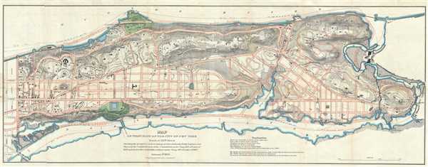
Napoleon Sarony (March 9, 1821 - November 9, 1896) was a dashingly handsome Canadian-American lithographer and publisher active in New York in the mid to late 19th century. Sarony was born in Quebec and emigrated to New York City in 1835. He apprenticed under Henry Robinson (fl. 1830/33 - 1850) before working as a lithograph artist for Nathaniel Currier (1813 - 1888). In 1846, he partnered with Currier's apprentice lithographer Henry B. Major to establish the firm of 'Sarony and Major.' From offices at 117 Futon Street, they published under this imprint until roughly 1853, when Sarony split off on his own under the imprint 'Sarony and Co.', still at 117 Fulton. At the time 'and Co.' probably meant Joseph Fairchild Knapp (1832 - 1891), Sarony's apprentice, and Richard C. Major, possibly Henry Major's son. In 1857, a new imprint was established as 'Sarony, Major and Knapp'. According to an advertisement in the New York Times (Feb 16, 1864), Sarony had invested in the business at founding, but was not an active partner, possibly because he was traveling in Europe. It is unclear why Sarony's name was maintained, possibly to capitalize on his fame, as a honorific, or possibly because he owned a major stake. They published under this imprint until 1863, becoming a major concern at 449 Broadway. Sarony's name was formally removed from the partnership in 1863. At the time he was traveling in Europe, mastering the most advanced color lithography and photographic techniques. He is known to have worked in France, Germany, and England. He returned to New York in the 1860s, establishing a photography company at 37 Union Square that became famous for its portraits of late-19th-century American theater icons. In 1891, Sarony, hoping to capitalize on Sarah Bernhardt's fame as 'Cleopatra', paid the stage actress 1,500 USD to sit for a photo session, the modern-day equivalent of 20,000 USD - suggesting a highly prosperous business. His son, Otto Sarony (1850–1903), continued the family business as a theater and film star photographer. As an aside, Sarony's second wife, Louie Sarony, was a known eccentric who would reportedly dress in elaborate rented costumes to walk around Washington Square each afternoon. More by this mapmaker...

Source


Thirteenth Annual Report of the Commissioners of the Central Park, (New York) 1870.    

Condition


Very good. Minor wear and toning along original fold lines. Minor spotting. Some rips, including minor tears along folds, repaired. Professionally flattened and backed with archival tissue.

References


Haskell, D. C., Manhattan Maps A Co-operative List, (New York 1931) #1228.