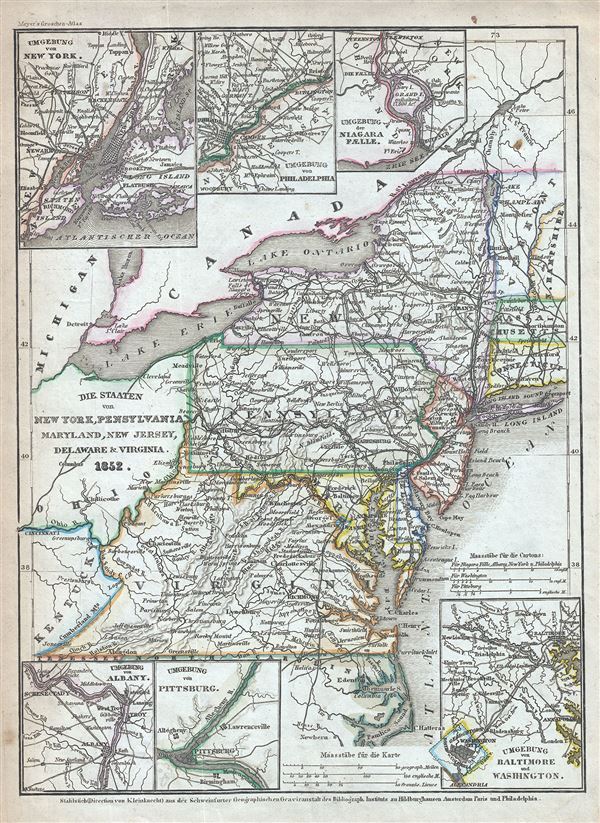
This is a fine example of Joseph Meyer's 1852 map of the Mid-Atlantic States. It covers New York, Pennsylvania, New Jersey, Maryland, New Jersey, Delaware and Virginia as well as parts of Connecticut, New Hampshire, Massachusetts and Vermont. Six inset maps are also included. These feature New York and vicinity, Philadelphia and vicinity, Niagara Falls and vicinity, Albany and vicinity, Pittsburg and vicinity and Baltimore and Washington DC and vicinity. This map covers Virginia before it was divided into West Virginia, and Virginia.
This map was issued at the height of the American westward expansion. A few years before this map was drawn the California gold discovery of 1849 enticed thousands to embark upon the rigorous transcontinental emigration. Meanwhile, with the rise in territorial population to the west of the Mississippi, the eastern states were becoming increasingly divided over the issues of slavery and state vs. federal sovereignty. In Virginia, around half a million people were enslaved. Within five years these disputes would lead to the American Civil War. The war would prove particular hard on Virginia as it hosted both the Union (Washington D.C.) and Confederate (Richmond) capitals and saw more Civil War battles than any other state. The Chesapeake Bay region was also the seat of the Civil War and many of its most important battles took place here. The Battle of Gettysburg, considered a major turning point of the Civil War, was fought in southern Pennsylvania in 1863. On another note, shortly after this map was this map was drawn, in 1859, oil was discovered in western Pennsylvania, leading to America's first oil boom and fueling the fortunes of John Rockefeller and others.
This map was issued in Meyer's Zeitung Atlas. Although all the maps in this atlas are not individually dated, the title page and maps were often updated while the imprint with the date was not, causing confusion to the exact date for some of the maps. Moreover some maps in the atlas were taped in at a later date as an update to the atlas. We have dated the maps in this collection to the best of our ability.
Cartographer
Joseph Meyer (May 9, 1796 - June 27, 1856) was a German industrialist and publisher, most notably for the encyclopedia Meyers Conversation-Lexicon. Born in Gotha, Germany, Meyer was educated as a merchant in Frankfurt am Main. He moved to London in 1816, but returned to Germany in a820 after his stock speculations and business adventures fell through. Once back in Germany, he began by investing in the textile trade (1820-24). Meyer began creating business plans concerning how to start railways soon after the first steam-hauled railway began operation in December 1835. He founded the Deutsche Eisenbahnschienen-Compangie auf Actien (German Railway Rail joint stock company) in 1845. Meyer also found great success as a publisher, utilizing the system of serial subscriptions to publications, a new idea for the time. He founded a company, Bibliographisches Institut in Gotha in 1825, which published several versions of the Bible, works of classical literature, atlases, the world in pictures on steel engravings, and an encyclopedia. More by this mapmaker...
Source
Meyer, J., Meyer's Zeitung Atlas, 1852.
Meyer's Zeitung Atlas, formally titled Neuster Zeitungs-Atlas Fuer Alte und Neue Erdkunde was a popular German hand-atlas published in Heidelberg by Joseph Meyer between, roughly, 1848 and 1859. The atlas is well engraved in the German style with exceptionally dense detail and minimal decoration. Meyer's Atlas, and its constituent maps, are typically very difficult to date as later editions often contain earlier maps and earlier editions later paste-in updates. That said, the atlas' frequent updates and publication run during a turbulent decade provide a noteworthy cartographic record of the period.
Very good. Minor overall toning and some foxing at places.