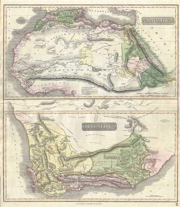
This unusual hand-colored 1817 map by John Thomson is essentially two maps in one: North Africa and South Africa. Thomson's decision to focus on these two parts of Africa may seem unusual until one realizes that these were in fact the only relatively well known parts of the 'dark continent.'
Northern Africa, particularly the Nile Valley and the Mediterranean Coast had long been visited by European merchants and travelers while, beyond the Sahara, the Niger River system had recently been explorer by the adventurers Mungo Park, Brown and others. Nonetheless speculation remained regarding he sources and course of the Niger, especially in the East, where a speculative river path leas south east from a proto-Lake Chad (Wancara or Ungara) through a speculative mountain range, the Mountains of the Moon or the Mountains of Kong. Park, and others postulated the existence of the Mountains of Kong stretching across central Africa in an attempt to explain the Niger. Further north, caravan routes crisscross the Sahara.
Southern Africa, a more pleasing climate to the Europeans, was in the meantime actively and aggressively being colonized by the Dutch and the English. Here, the region is divided into various provinces including the recently acquired British Cape District and Zwellingdam, and the Dutch / Afrikaans Territories of Stellenbosch and Graaff Reyn. Numerous transcontinental routes are identified, as are areas commendable to settlement, pasturage, and development. Of particular note is the route of John Campbell, an English Missionary through Zwellingdam. Campbell was commissioned to reconnaissance the area and provide a detailed report on the territory's country, settlements, and people. His report was highly regarded in its time and provided some of the best information about South Africa available in England. The whole is beautifully engraved in the minimalist English style pioneered in the early part of the 19th century. Thomson maps are known for their stunning color, awe-inspiring size, and magnificent detail. Thomson's work, including this map, represents some of the finest cartographic art of the 19th century. Relief is shown by hachure with towns, cities, and major topographical features identified. This map was prepared by John Thomson for inclusion in the 1817 edition of Thomson's New General Atlas.
Cartographer
John Thomson (1777 - c. 1841) was a Scottish cartographer, publisher, and bookbinder active in Edinburgh during the early part of the 19th century. Thomson apprenticed under Edinburgh bookbinder Robert Alison. After his apprenticeship he briefly went into business with Abraham Thomson. Later the two parted ways, John Thomson segueing into maps and Abraham Thomson taking over the bookbinding portion of the business. Thomson is generally one of the leading publishers in the Edinburgh school of cartography which flourished from roughly 1800 to 1830. Thomson and his contemporaries (Pinkerton and Cary) redefined European cartography by abandoning typical 18th century decorative elements such as elaborate title cartouches and fantastic beasts in favor of detail and accuracy. Thomson's principle works include Thomson's New General Atlas, published from 1814 to 1821, the New Classical and Historical Atlas of 1829, and his 1830 Atlas of Scotland. The Atlas of Scotland, a work of groundbreaking detail and dedication would eventually bankrupt the Thomson firm in 1830, at which time their plates were sequestered by the court. The firm partially recovered in the subsequent year allowing Thomson to reclaim his printing plates in 1831, but filed again for bankruptcy in 1835, at which time most of his printing plates were sold to A. K. Johnston and Company. There is some suggestion that he continued to work as a bookbinder until 1841. Today, Thomson maps are becoming increasingly rare as they are highly admired for their impressive size, vivid hand coloration, and superb detail. More by this mapmaker...
Source
Thomson, J., A New General Atlas, (Edinburgh) 1817.
Thomson's New General Atlas was first published in 1817 and continued to be published until about 1821. This is the first of Thomson's major cartographic works and the atlas for which is most celebrated. The New General Atlas follows in the Edinburgh School, which eschews excessive decoration in favor of a more minimalistic fact-based cartographic vision, as established by John Pinkerton, Laurie and Whittle, John Cary, and others in the previous decades. The maps are notable for their massive scale, heavy stock, elegant color work, and easy-to-read typefaces. Although the atlas stopped being published after 1821, Thomson continued to offer 'supplementary' maps that could be tipped into the atlas as late as 1830, when he declared bankruptcy. The maps in the Thomson Atlas were engraved by Thomas Clerk, William Dassauville, Nathaniel Rogers Hewitt, James Kirkwood, Robert Kirkwood, John Menzies, George Menzies, Edward Mitchell, John Moffatt, Samuel John Neele, Robert Scott, and James Wyld.
Very good. Minor wear along original centerfold. Original platemark visible. Overall toning and foxing at places.
Rumsey 1007.054. Phillips (Atlases) 731. Newberry Library: Ayer 135 T4 1817.