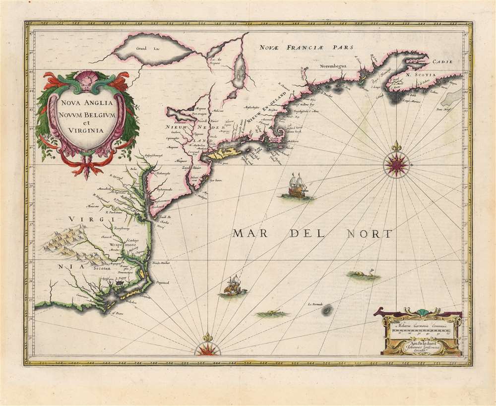
A fine first edition first state old color example of Jan Jansson's 1636 map of the northeast American coastline from Cape Lookout (here identified as C. of Feare) to Nova Scotia. The map includes parts of modern day North Carolina, Virginia, Maryland, Delaware, New York, New Jersey, Massachusetts, Connecticut, Rhode Island, Vermont, New Hampshire, Maine, and Nova Scotia. Most particularly, it offers some of the earliest depictions of the Chesapeake Bay, Delaware Bay, Manhattan Island, New Amsterdam, Long Island, and the Great Lakes.
Cartographically Jansson derived this map from the 1630 map of Johannes de Laet and Hessel Gerritsz. Though it is presented on a much larger scale, Jansson's map adheres closely to the de Laet nomenclature with few changes of significance. In addition to increasing the map's scale, Jansson also enlarged the scope of his map to cover additional lands to the north and west. Jansson's adherence to the de Laet model continues on the verso where the de Laet text describing the region is transcribed verbatim.
A large decorative title cartouche of a baroque ethic in the upper left quadrant present's the map's title
Nova Anglia Novum Belgium et Virginia. The title sets the stage for the map as a whole, which can best be understood as a pageant of conflicting colonial and economic interests, in particular rivalries between English, Dutch, and French colonies. The very title, in which Nova Anglia supersedes Novum Belgium (named after the Belgian based Walloon Protestants who were the primary backers of the Dutch West India Company), exemplifies many of these issues. In subsequent editions of this map Jansson reversed the title order giving Novum Belgium precedence.
Jansson centers the map on New Nederland and more specifically on the Hudson Valley, sandwiched between English colonies in Nieuw Engeland (New England) and Virginia (Jamestown). Along the Hudson, identified using the Dutch term Noorde Rivier, Fort Orange (near modern day Albany) and New Amsterdam (New York) are identified. As this map was being drawn English and Dutch trappers would have been in fierce competition over the peltries along the Hudson, Connecticut (here Versche Rivier), and Delaware (here Zuydt Rivier) Rivers. These rivalries would eventually escalate into the English takeover of New Amsterdam in 1664 and its subsequent reassignation as New York.
Further north the complex and confusing network of lakes and rivers stands out as one of the map's most prominent features. The closest lake to New Amsterdam, identified as Seccecaas, after the Seneca, an Iroquois people, most likely represents Lake Oneida, which European trappers may have heard of from their American Indian trading partners but would not have encountered directly. The lakes further north, Lake Iroquois (Yroquois), Grand Lac, and a third unnamed lake, doubtless represent some combination Lake Champlain and the Great Lakes. Some scholars have noted the curious omission of the early 17th discoveries of Samuel de Champlain that Jansson would doubtless have been familiar with and which shed considerable light on these regions. This is no casual error, but rather a powerful assertion not only of Dutch cartographic supremacy, but also a political denial of competing French claims to the region which resulted from the Champlain expedition and the founding of Quebec.
As a consequence, distinguishing the identity of these lakes is rather challenging. The unnamed lake to the right of the primary cluster is most likely Lake Champlain. The next lake, labeled 'Lac des Yroquois' is in all likelihood Lake Ontario, but possibly Lake Erie. The term, 'Lake of the Iroquois' will later be used to refer more specifically to Lake Champlain. The largest lake, 'Grand Lac' is a matter of some dispute. Karpinski suggests this is the first map to fully depict Lake Superior in full, but Burden, calling him to task, correctly asserts that there is no evidence to suggest this as Lake Superior. To our eye, it is most likely an embryonic representation of either Lake Erie or Lake Huron, or some amalgam of both. Regardless of which lakes are represented, Jansson's map is highly significant as one of the earliest Dutch attempts to address the Great Lakes in any detail.
The region of modern day Maine is identified using the archaic term Norembegua. This mysterious land appeared on many early maps of New England starting with Verrazano's 1529 manuscript map of America. He used the term, Oranbega, which in Algonquin means something on the order of 'lull in the river'. The first detailed reference to Norembegua, or as it is more commonly spelled Norumbega, appeared in the 1542 journals of the French navigator Jean Fonteneau dit Alfonse de Saintonge, or Jean Allefonsce for short. Allefonsce was a well-respected navigator who, in conjunction with the French nobleman Jean-François de la Roque de Roberval's attempt to colonize the region, skirted the coast of south of Newfoundland in 1542. He discovered and apparently sailed some distance up the Penobscot River, encountering a fur rich American Indian city named Norumbega - somewhere near modern day Bangor, Maine.
The river is more than 40 leagues wide at its entrance and retains its width some thirty or forty leagues. It is full of Islands, which stretch some ten or twelve leagues into the sea. ... Fifteen leagues within this river there is a town called Norombega, with clever inhabitants, who trade in furs of all sorts; the town folk are dressed in furs, wearing sable. ... The people use many words which sound like Latin. They worship the sun. They are tall and handsome in form. The land of Norombega lies high and is well situated.
Though Roberval's colony lasted only two years, Andre Thevet, writing in 1550, records encountering a French trading fort at the site of Norumbega. A few years later in 1562, an English slave ship wrecked in the Gulf of Mexico. David Ingram, one of the survivors, claimed to have trekked overland from the Gulf Coast to Nova Scotia where he was rescued by a passing French ship. Possibly inspired by Mexican legends of el Dorado, Cibola, and other lost cities, Ingram returned to Europe to regale his drinking companions with boasts of a fabulous city rich in pearls and built upon pillars of crystal, silver, and gold. The idea caught on in the European popular imagination and expeditions were sent to search for the city - including that of Samuel de Champlain.
The legend of Norumbega thus seems to have transitioned from Allefonsce's most likely factual description of a lively American Indian fur trading center, to Thevet's French trading fort, to Ingram's fabulous paradise dripping in wealth. Allefonsce's description of the American Indians he encountered in Norumbega corresponds well those of Hudson, who also met a tall well-proportioned people. Sadly only a few years later many of these tribes began to die off at extraordinary rates (over 90% of the population perished) due to horrifying outbreaks of small pox and other diseases carried by the unwitting European explorers. It seems reasonable that Allefonsce may have stumbled upon a periodic or semi-permanent indigenous fur trading center on the Penobscot. It also seems reasonable that French colonists may have set up their fur trading post at the same site, for it was fur, not gold that was the real wealth of New England and Norumbega. Alas, it was Ingram's fictitious account, which though wholly the product of drunken sailor's imagination, produced the most enduring image of Norumbega.
In the Chesapeake Bay region and further south Jansson offers some detail regarding the complex river systems. English settlement in the region is limited to Jamestown though American Indian villages are well represented and thorough. De Laet extracted most of the cartography and nomenclature for this region from the impressive 1590 John White map although here it has been somewhat refined. The mountains presented inland, while not inaccurate, are been largely speculative or based upon American Indian geographic descriptions.
Several ships ply the seas and compete with two decorative compass roses, a recognizable Bermuda, and a secondary cartouche in the lower right quadrant featuring Jansson's imprint as well as a distance scale. This map was issued for the 1636
Appendix Atlantis Oder dess Welt Buchs but examples can also be identified in various editions of Mercator's
Atlas Novus which was published in the same year. The present example, being a first state, features French text on the verso indicating that was extracted from the 1639 issue of the
Nouvel Atlas.
Very good. Original centerfold. Full margins. Old Color. French text on verso.