This item has been sold, but you can get on the Waitlist to be notified if another example becomes available, or purchase a digital scan.

1783 Santini Map of the Kingdom of Slavonia (Croatia, Serbia, Bosnia)

RoyaumeDEsclavonie-santini-1783
$225.00
Carte du Royaume D'Esclavonie et du Duche de Syrmie, dont l'un et l'autre est arrose par le Danube, l'Illove, La Save, et la Drave. - Main View
Processing...

1783 Santini Map of the Kingdom of Slavonia (Croatia, Serbia, Bosnia)

RoyaumeDEsclavonie-santini-1783

Beautiful map of the Kingdom of Slavonia.

Title


Carte du Royaume D'Esclavonie et du Duche de Syrmie, dont l'un et l'autre est arrose par le Danube, l'Illove, La Save, et la Drave.
  1783 (dated)     19 x 23 in (48.26 x 58.42 cm)     1 : 610000

Description


This is a beautiful example of Paolo Santini’s 1783 map of the Kingdoms of Slavonia and Syrmia depicting parts of modern day Croatia, Serbia, Bosnia and Herzegovina as well as parts of Hungary. The map extends south from Tolna in Hungary to Sarajevo and from Banja Luka in Bosnia and Herzegovina east as far as Belgrade in Serbia. The entire region is depicted in extraordinary detailed, offering both topographical and political information, with forests and mountains beautifully rendered in profile.

The Kingdom of Slavonia existed from 1699 to 1868 as a province of the Hubsburg Monarchy and later the Austrian Empire. In 1868 it was united with the Kingdom of Croatia to form the Kingdom of Croatia-Slavonia.

A beautifully decorative title cartouche appears near the top right quadrant of the map. Considered one of the most detailed maps of the region from the mid-18th century. Issued by Paolo Santini in his Atlas Universel.

Cartographer


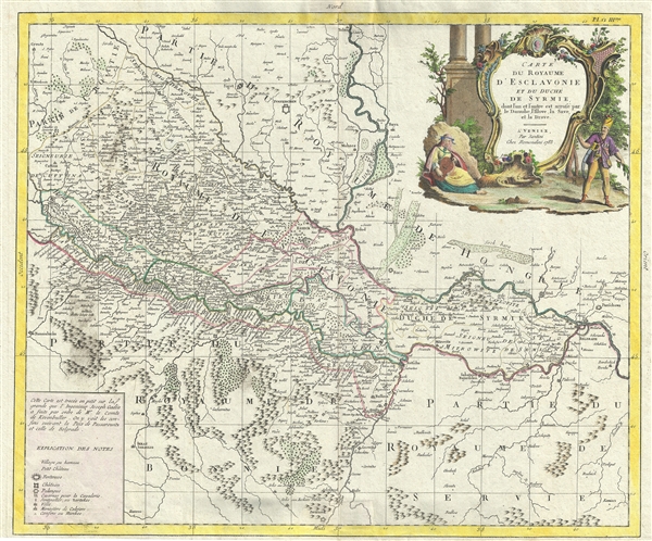
Francois [Francesco] Santini (fl. 1776 - 1784) was an Italian cartographer and map publisher based in Venice. Francois Santini is often confused with Paolo Santini, a Venetian engraver also known for religious prints and cartographic work. Scholarship is unclear whether these are related individuals, the same person, or completely unrelated. Both cartographers were active in roughly the same period and reissued maps of earlier French cartographers ranging from Vaugondy, to Jaillot, to De L'Isle, to D'Anville. Both cartographers also worked with the Venetian Remondini publishing house. Paolo was possibly an Abbot. Francois Santini seems to have worked extensively in Paris and is associated with several French cartographers of the late 18th century including Rigobert Bonne. His offices in Paris were located at Rue St. Justine pres de L'Eglise. In the 1780s Francois Santini published an atlas, the Remondini Atlas Universel, in conjunction with the Remondini family of Venice. The Library of Congress associates this work with Paolo Santini - leading to still more confusion. More by this mapmaker...

Condition


Very good. Minor wear along original centerfold. Minor toning and foxing. Original platemark visible.

References


OCLC: 605195326.