This copy is copyright protected.
Copyright © 2024 Geographicus Rare Antique Maps
1896 Anderson Large Map of Seattle, Washington
Seattle-anderson-1896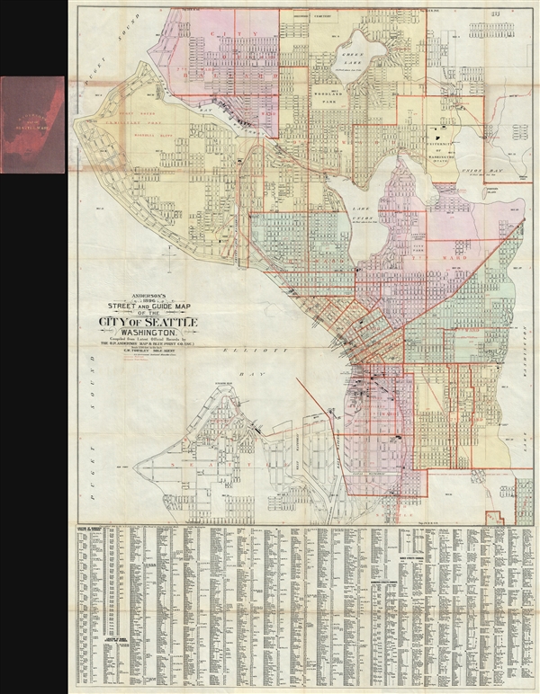

Oliver Phelps Anderson (August 1859 – April 15, 1941) was a Seattle based photographer, draughtsman, businessman, and cartographer active from the latter part of the 19th century into the early 20th century. Anderson was born in Lexington, Illinois, the son of Alexander J. Anderson (1833 - 1903), a college professor. From 1882, Anderson was married to novelist Ada Woodruff Anderson (1860 - 1956) of San Francisco on June 4 of 1882. By the late 1880s Anderson had started his own business as a draughtsman. He opened a civil engineering and map publishing business, O. P. Anderson and Company around 1890. In this capacity he published several maps with W. H. Whitney (a somewhat mysterious figure) for the Northern Pacific Railroad. In addition to his work as a draughtsman and mapmaker, Anderson was a lifelong hobbyist photographer. As a hobbyist photographer and professional draughtsman Anderson was experienced with early cyanotype processes and quickly realized their potential for cartography. He released many of his maps in blueprint to facilitate rapid annotation and corrections before sending them to out for printing. Anderson's use of cyanotype photography to produce prototypes of his maps is, as far as we know, unique. Most of his map focus on the Seattle area, and King County, but some few also detail Alaska and the Yukon Gold Fields. Embracing his hobby, he opened a photography supply house, the Anderson Supply Company, located at 111 Cherry Street, Seattle, around 1900. Around 1913, Anderson’s son Maurice P. Anderson took over as president of the company, and Anderson acted as secretary-manager, a position he continued to hold until around 1940, probably until his death. Anderson Supply Co. continued to do business, with Maurice Anderson as president, until the late 1950s. Anderson's surviving hobbyist photographs are an important records of Seattle's development correspondent during its most meteoric period of growth in the late 19th century. Today many of Anderson's photographs are archived at the Sophie Frye Bass Library. More by this mapmaker...
Christopher W. Towsley (fl. c. 1880 – c. 1914) was a Seattle based printer and businessman active in the latter part of the 19th century. Towsley produced maps for government and civil engineering use and partnered with Oliver Phelps Anderson to issue commercial maps of Seattle and King County. He is also registered as a principal of the Pioneer Rent & Collection Company, a real estate concern. Learn More...
Copyright © 2024 Geographicus Rare Antique Maps | Geographicus Rare Antique Maps
This copy is copyright protected.
Copyright © 2024 Geographicus Rare Antique Maps