This item has been sold, but you can get on the Waitlist to be notified if another example becomes available, or purchase a digital scan.

1794 Laurie and Whittle Nautical Map of Trincomalee, Ceylon (Sri Lanka)

Trincomalay-lauriewhittle-1794
$250.00
Plan of the Bay and Harbour of Trincomalay, on the Island of Ceylon. - Main View
Processing...

1794 Laurie and Whittle Nautical Map of Trincomalee, Ceylon (Sri Lanka)

Trincomalay-lauriewhittle-1794

Since antiquity Ceylon's Trincomalee has been renowned the finest harbor on the Indian Ocean.

Title


Plan of the Bay and Harbour of Trincomalay, on the Island of Ceylon.
  1794 (undated)     21 x 29 in (53.34 x 73.66 cm)     1 : 11520

Description


This is a fine example of Laurie and Whittle's 1794 nautical chart or maritime map of the Bay and Harbor of Trincomalee, Sri Lanka. Trincomalee is the largest and safest natural port in the Indian Ocean, accessible to all crafts in any weather condition. It has been renowned as a port since ancient times and was mentioned by both the Venetian merchant traveler Marco Polo and Alexandrian cartographer Claudius Ptolemy. By the end of the 18th century the port had changed hands several times and, as this map was being drawn, Trincomalee had been alternately under Dutch and French control over the previous fifty years. The British would capture it one year later, in 1795, and hold it until Sri Lankan Independence in 1948.

Laurie and Whittle prepared this chart for their 1799 issue of the East-India Pilot. Cartographically this chart is derived from earlier maps prepared for Jean-Baptiste d'Apres de Mannevillette's 1745 Neptune Oriental. It was subsequently resurveyed, updated and revised at the command of Admiral Cornish in 1762. The map offers rich detail including countless depth soundings, notes on the sea floor, commentary on reefs, rhumb lines, shoals, place names and a wealth of other practical information for the mariner.

Cartographer


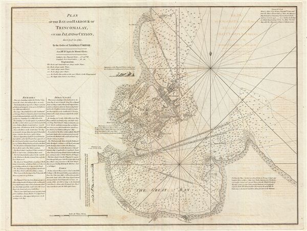
Laurie and Whittle (fl. 1794 - 1858) were London, England, based map and atlas publishers active in the late 18th and early 19th century. Generally considered to be the successors to the Robert Sayer firm, Laurie and Whittle was founded by Robert Laurie (c. 1755 - 1836) and James Whittle (1757-1818). Robert Laurie was a skilled mezzotint engraver and is known to have worked with Robert Sayer on numerous projects. James Whittle was a well-known London socialite and print seller whose Fleet Street shop was a popular haunt for intellectual luminaries. The partnership began taking over the general management of Sayer's firm around 1787; however, they did not alter the Sayer imprint until after Sayer's death in 1794. Apparently Laurie did most of the work in managing the firm and hence his name appeared first in the "Laurie and Whittle" imprint. Together Laurie and Whittle published numerous maps and atlases, often bringing in other important cartographers of the day, including Kitchin, Faden, Jefferys and others to update and modify their existing Sayer plates. Robert Laurie retired in 1812, leaving the day to day management of the firm to his son, Richard Holmes Laurie (1777 - 1858). Under R. H. Laurie and James Whittle, the firm renamed itself "Whittle and Laurie". Whittle himself died six years later in 1818, and thereafter the firm continued under the imprint of "R. H. Laurie". After R. H. Laurie's death the publishing house and its printing stock came under control of Alexander George Findlay, who had long been associated with Laurie and Whittle. Since, Laurie and Whittle has passed through numerous permeations, with part of the firm still extant as an English publisher of maritime or nautical charts, 'Imray, Laurie, Norie and Wilson Ltd.' The firm remains the oldest surviving chart publisher in Europe. More by this mapmaker...

Source


Laurie, R., and Whittle, J., The East-India Pilot, or Oriental Navigator, on One Hundred and Eighteen Plates: Containing a Complete Collection of Charts and Plans, &c., &c. for the Navigation not only of the Indian and China Seas, but of those also between England and the Cape of Good-Hope; Improved and Chiefly Composed from the Last Work of M. D'Apres de Mannevillette; with Considerable Additions, from Private Manuscripts of the Dutch, and from Draughts and Actual Surveys Communicated By Officers of the East-India Company A New Edition, Containing One Hundred and Five Charts. (London: Laurie and Whittle) 1797.    

Condition


Very good. Minor wear and verso repair along original centerfold. Original platemark visible. Some offsetting.