This item has been sold, but you can get on the Waitlist to be notified if another example becomes available, or purchase a digital scan.

1947 Breinholt Pictorial Map of the Utah Valley

UtahValley-breinholt-1947
$100.00
Scenic Utah Valley.  Home of Geneva Steel Plant.  Utah's Richest Framing Area. - Main View
Processing...

1947 Breinholt Pictorial Map of the Utah Valley

UtahValley-breinholt-1947

Pictorial map drawn to promote tourism and settlement of the Utah Valley.

Title


Scenic Utah Valley. Home of Geneva Steel Plant. Utah's Richest Framing Area.
  1947 (undated)     21 x 16 in (53.34 x 40.64 cm)     1 : 135000

Description


An attractive c. 1947 pictorial map of the Utah Valley by Floyd Emil Breinholt. The map covers Utah Lake and the regions south as far as Nephi, and east as far as Strawberry Lake. The map was drawn to promote tourism and development in the beautiful Utah Lake region. At the time, the Utah Valley was particularly proud of the Geneva Steel Plant, a large industrial facility established in 1944 to supply the United States military in during World War II. The map includes numerous vignettes intended to advertise the regions rich natural resources, including steel, oil, and farming, as well as to promote its potential for outdoor life in the form of hinting, camping, hiking, and fishing. It was issued by Greater Utah Valley Inc. of Provo, Utah. The verso features scenic images of the region.

Cartographer


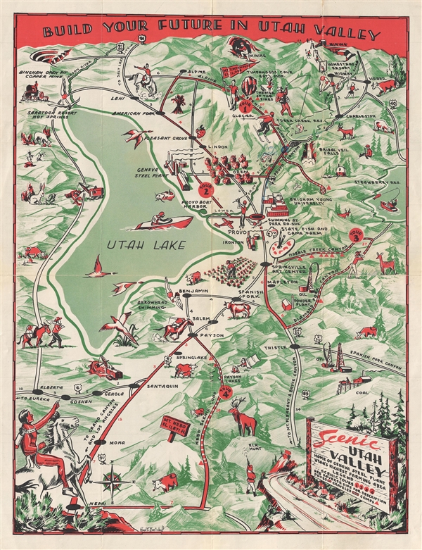
Floyd Emil Breinholt (1915 – 1997) was a Utah based visual artist, painter, and educator. He was born in Ephraim, Utah in 1915. Breinholt received a degree from Snow College in 1935. He later earned a BS in 1937, and a masters in education in 1953 from Brigham Young University. He also attended the Art Students League in New and the Art Center School in Los Angeles. He became a professor of art at Brigham Young University in 1961. Breinholt died in Provo, Utah in 1997. More by this mapmaker...

Condition


Very good. Minor verso reinforcement along some of the original fold lines.