This item has been sold, but you can get on the Waitlist to be notified if another example becomes available, or purchase a digital scan.

1886 Torakichi Maeda Map of the World

World-torakichimaeda-1886
$750.00
Kaisei shinpan bankoku meisai zenzu. /萬國明細全圖, 改正新版 / Complete, Detailed World Map, Revised and Updated. - Main View
Processing...

1886 Torakichi Maeda Map of the World

World-torakichimaeda-1886

One of the first, if not the first, Japanese World Map to incorporate western style Comparative Mountains and Rivers charts.

Title


Kaisei shinpan bankoku meisai zenzu. /萬國明細全圖, 改正新版 / Complete, Detailed World Map, Revised and Updated.
  1886 (dated)     19.25 x 27.5 in (48.895 x 69.85 cm)     1 : 75400000

Description


A scarce Japanese map of the world issued in 1886 (Meiji 19) by Maeda Torakichi, significant for its incorporation of Western scientific data. Most importantly, this is one of the first, if not the first, example of European style comparative world mountains and rivers charts to appear on a Japanese world map.
A Closer Look
The map covers the entire world on a double hemisphere projection. Some geographical features are clearly off-base, such as, in the United States, a large desert to the east of the Rocky Mountains ('Great Mamesaka Desert' 大マメサカ砂漠) and a disconnected Great Lakes. On the whole, though, the map exhibits considerable accuracy. Notably, both the Russian and Qing empires are divided into constituent parts (in the latter case, Manchuria, Mongolia, and 'Chinese Tartary' - though not Tibet - are colored distinctly from China proper).

In the lower-right, there is a comparative chart illustrating the heights of world mountains with divisions by continent, while at upper-left is a comparative rivers chart (divided by continent). This was a significant cartographic development given that similar world maps incorporating mountains and rivers chart only started appearing in American and European publications about three years earlier.

In the upper-right, a beautifully engraved chart expresses time zones and places major cities in their respective time zones, explained in the purple box to the left. A flag chart appears in the lower-left, which reveals some inaccuracies in the imagery of the flags and the still-developing terminology for foreign countries (such as the United States as 合眾國 instead of 米國 or アメリカ, the Russian Empire as 魯西亜帝國 instead of 露國, and Spain as 是班牙 instead of 西班牙). Curiously, more conventional transliterations of countries' names appear in a table at bottom-left, above the publication information, which includes information on the capital cities and major ports of other counties, with distances from Tokyo and number of days required for travel.
Publication History and Census
This map was edited and published by Maeda Torakichi (前田虎吉) in 1886 (Meiji 19). It was distributed by Tanaka Jihē (田中治兵衛) in Kyoto, along with Usagiya (兎屋), Shinshindō (駸々堂), Tōkyōya (東京屋), all based in Osaka. The map is rare, with known examples only being held by the University of California Berkeley, the State Library of New South Wales, and the National Diet Library.

CartographerS


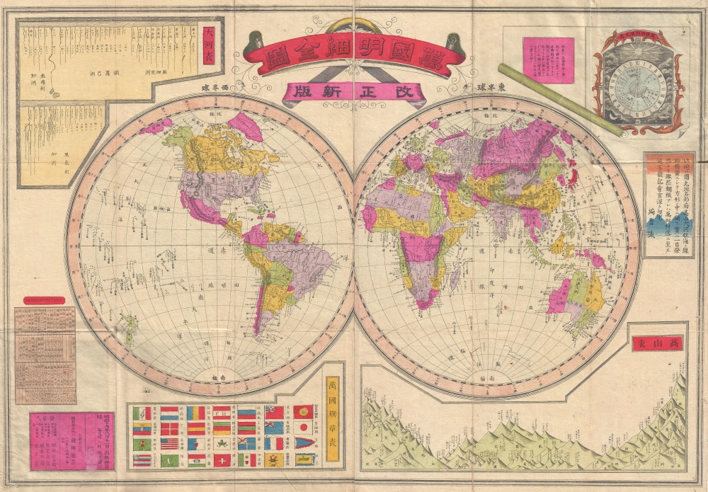
Torakichi Maeda (虎吉前田, fl. c. 1880 – 1890) was a Japanese author and publisher active in Osaka during the latter part of the 19th century. More by this mapmaker...


Shinshindō (駸々堂; c. 1881 - 2000) was a bookstore and publisher founded by Oobuchi Wataru 大淵渉 (1855 ‐ 1907) in Kyoto. The company later moved to Osaka and went through several name changes over the course of the twentieth century, developing a niche market for study guides and test preparation books in the process, but ultimately going bankrupt in 2000. Learn More...

Condition


Very good. Minor wear on original fold lines. Folds into original binder.

References


OCLC 21788916, 675844572.