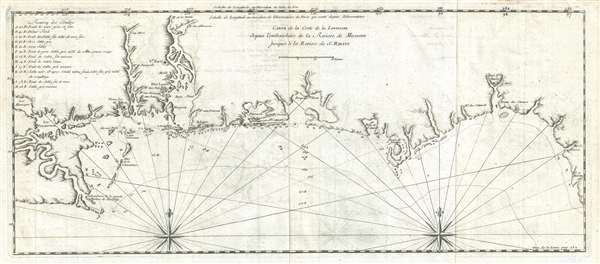
An extremely rare and important 1728 Antoine Laval map of the Mississippi River Delta and the coast of Louisiana and Mississippi. The map covers from Lake Pontchartrain and Lake Maurepas eastward along the coast past the Delta of the Mississippi, Mobile bay, Pensacola Bay, and St. Joseph Bay, as far east as Apalachee Bay and western Florida. Although primarily a coastal reconnaissance, it does extend inland somewhat along the Mississippi, Pascagoula, Walulla, and Mobile Rivers. A chart in the upper right describes 12 different types of sand conditions typically found in the Gulf. Various forts are identified including Biloxi, Fort Louis de la Louisiane (Mobile Bay), and Fort St. Marie (St. Marks, Florida). Soundings dot the coast between Biloxi and the Apalachicola River.
The map is attributed to the Jesuit priest Antoine Laval, whose mission was to explore and map the Louisiana Coast, and specifically to triangulate the longitude for the mouth of the Mississippi River. The crews of the expeditions two ships, under the command of Valette-Laudun, the Comte de Toulouse and the St. Henri were unfortunately struck by an illness which Laval spent the remainder of the voyage tending. He made few observations and in fact, never left Dauphin Island or even see the Mississippi. Nonetheless, he must have collected some information, as his map of the coast closely follows a manuscript map illustrated by Jackson in Flags Along the Coast (opposite page 59) and attributed to 'a [Spanish] pilot named Soupar (or Soupart).' The Soupar chart found its way into the maps of Francois le Maire, from which may have been derived. However, it is our opinion, after a close study, that Laval must have had access to or seen a more precise copy of the Soupar manuscript as the cartography is deeply identical, more so than is apparent on the De Fer derivative. The primary differences are in the Pensacola Bay region, which is here mapped with greater sophistication than on the Soupar Map. This to be expected, as Laval does give an account by a participant of the capture of Pensacola the previous year by the French, and its recapture a few weeks later by the Spaniards. It is not unlikely that these events produced some new cartography for the Pensacola Bay region.
This map was issued, along with a detail chart of Pensacola Bay, in Laval's Voyage de la Louisiane, published by Jean Mariette in Paris, 1728. Although this volume is occasionally obtainable, the separate map otherwise rarely seen on the market. It remains the best obtainable example of the Soupar manuscript and an important early map of the Gulf coast east of New Orleans.
Cartographer
Antoine Jean de Laval (1664 – 1728) was a French Jesuit priest and scientist active in the late 16th and early 17th century. Laval was a royal professor of hydrography and mathematics based in the city of Toulon. Laval is best known for his 1720 voyage along the Gulf Coast to triangulate the exact longitude of the Mouth of the Mississippi River. Laval never obtained his objective, in fact may never have seen the Mississippi River, but did publish an important account of the region in his 1728, Voyage de la Louisiane. More by this mapmaker...
Source
Laval, Antoine Jean de, Voyage de la Louisiane (Paris: Jean Mariette), 1728.
Very good. Original fold marks. Pressmark visible.
Phillips (America) page 368. OCLC 494647588. Jackson, J., Flags along the Coast: Chart the Gulf of Mexico, 1519 - 1759: A reappraisal, pages 64-65, plate opposite page 59.