
World War II
Operational archive documenting the final preparations for the invasion of Okinawa, the last great amphibious campaign of World War II.
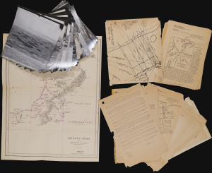
Okinawa Shima and Adjacent Islands. Screen Plan Okinawa--1. / U.S.S. Monrovia (APA-31) Amphibious Assault on Okinawa.
$18,000.00
Acquire
An extraordinary discovery and an even more improbable survival, this archive from the U.S.S. Monrovia preserves the operational record of the April 1, 1945, Invasion of Okinawa, the final great amphibious campaign of World War II (1939 - 1945). Comprising aerial reconnaissance photographs, operational maps, and briefing papers prepared as late as March 31, 1945, the collection captures the tense final hours before the assault. Few surviving archives so vividly illustrate the intelligence, planning, and meticulous coordination behind one of the most consequential military landings of the twentieth century. (more details)
Gigantic movie poster and map illustrating a Japanese perspecitive on World War II battle for the Pacific.
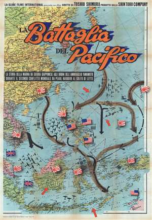
Battaglia del Pacifico.
$6,500.00
Acquire
- Digital Map Information
- Suitable for large format printing
- File Size: 152.77 MB
- File Type: ZIP / TIFF
- ICC color profile embedded
- Delivered instantly via download link
This monumental and rare movie poster and map of East Asia and the Pacific was issued by Vecchioni and Guadango to promote the 1959 Italian release of the post World War II (WW2) 1958 Japanese film Battaglia del Pacifico . The poster takes the form of an enormous ... (more details)
Unique record of D-Day.
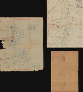
Operations Overlay. Annex No. 1 to F.O. No. 1. HQ-357th Inf. 28 May 1944. / ADM. OVERLAY. France 1:25000 GSGS-4250. NEPTUNE ANNEX#2 TO FO#1 HQ 357th INF, May 28, 1944. / Annex 3a. Overlay to Accompany Intelligence Annex to FO #1 HQ 357th INF. 28 May 1944.
$6,000.00
Acquire
This is a collection of three 1944 World War II manuscript map overlays created nine days before the D-Day invasion in Normandy (May 28, 1944), all of which bear the classification BIGOT - TOP SECRET. All three were drawn for the 357th Infantry Regiment, which landed on Utah Beach on June 8, 1944, two days after D-Day. The overlays provide insight into how infantry soldiers prepared and the details these men valued enough to carry into the field. These overlays were found sewn into the collar of a uniform jacket a soldier received in the field. (more details)
Ornate Wartime Bird's-Eye View of Mecca.
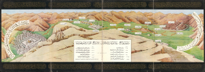
رسم مشاعر الحج : نقلا عن كتاب مراة الحرمين لأمير الحج اللواء ابراهيم رفعت باشا / [Depicting the Emotions of Hajj: Excerpted from the book Mir'at al-Haramayn by the Commander of the Hajj Caravan, Major General Ibrahim Rifaat Pasha].
$6,000.00
Acquire
- Digital Map Information
- Suitable for large format printing
- Full resolution TIFF file
- ICC color profile embedded
- Delivered instantly via download link
This is a c. 1942 decorative Hajj souvenir view of the Muslim holy city of Mecca (Makkah) and surroundings, based on the work of Ibrahim Rifat Pasha. Taking in the Kabaa, the Great Mosque, and the Plain of Arafat, it would have been intended for a Hajji to remind them of the apex and core ritual components of their pilgrimage. (more details)
Produced by Poland's Nazi-Hunting Commission.
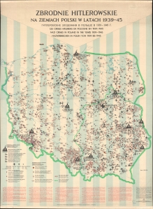
Zbrodnie Hitlerowskie na Ziemiach Polski w Latach 1939-45. [Hitler's Crimes in Poland 1939-45.]
$6,000.00
Acquire
A chilling 1971 wall map documenting Hitler's war crimes in Poland published for the Polish commission established to hunt and prosecute Nazi war criminals. The map's scope, focus, and execution transcend the purely geographic in illustrating the horrors of the Holocaust. Its extreme significance reflects broad efforts by scholars, mapmakers, and other researchers throughout the 1960s-70s to record and preserve knowledge of the Holocaust. It is ever more poignant in the light of modern revisionist historical research that has re-evaluated the Polish role in the Holocaust, as well as efforts by the current Polish government to legislate and control the historical record. (more details)
Soviet-themed anti-Nazi propaganda in Poland.
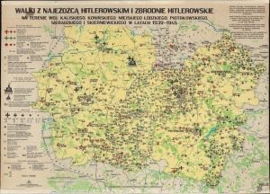
Walki z Najeźdźcą Hitlerowskim i Zbrodnie Hitlerowskie na Terenie Woj.: Kaliskiego, Konińskiego, Miejskiego Łódzkiego, Piotrkowskiego, Sieradzkiego i Skierniewickiego w Latach 1939 - 1945. / Armed Struggle Against the Nazi Invader and Nazi Crimes in Kalisz, Konin, Łódź, Poitrków Tryb., Sieradz and Skierniewice Voivodeships in the Years 1939 - 1945.
$4,000.00
Acquire
A chilling 1971 wall map detailing Hitler's crimes and the fight against the Nazi invasion and occupation in the voivodeships of Kalisz, Konin, Łódź, Piotrków Tryb., Sieradz and Skierniewice in central Poland. It was published by the Provincial Committees for the Protection of Monuments to Struggle and Martyrdom. It is ever more poignant in the light of modern revisionist historical research that has re-evaluated the Polish role in the Holocaust, as well as efforts by the current Polish government to legislate and control the historical record. All text on this piece is in Polish, Russian, English, French, and German.The map depicts the 6 voivodeships east of Warsaw. Icons detail Nazi crimes. The largest marks Chełmno, the first Nazi extermination camp. Two others mark concentration camps for children. Black Iron Crosses mark mass execution sites, with the size of the cross corresponding to the magnitude of the massacre. The largest crosses, such as those in Łódź and near Kazimierz Bisk and Gołuchów, symbolize massacres of over 10,000 individuals. Corresponding symbols mark towns that were destroyed and their populace exterminated, towns that were partially destroyed and exterminated, and towns where the population was deported. Small red shovels surrounded by barbed wire identify forced labor camps. Symbols also mark prisoner-of-war camps and sites of crimes committed against Polish and Soviet Prisoners of War. (more details)
Anti-Nazi, Pro-Soviet Propaganda in Poland.
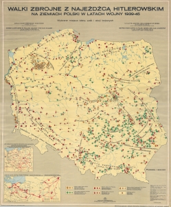
Walki Zbrojne z Najeźdźcą Hitlerowskim na Ziemiach Polski w Latach Wojny 1939 - 45. / Armed Campaigns in Poland Against the Nazi Invader in the Years of War 1939 - 1945.
$4,000.00
Acquire
This is a 1972 Polish multilingual educational wall map of Poland chronicling the resistance to the World War II Nazi invasion. The map lionizes Polish and Red Army accomplishments in resisting the Nazi plague but, as a product of the Eastern Bloc, conveniently ignores the 1939 Sovient Invasion and related atrocities. (more details)
Published by Krakow's Committee for the Protection of Monuments of Struggle and Martyrdom.
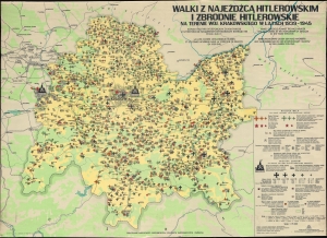
Walki Z Najeźdźcą Hitlerowskim I Zbrodnie Hitlerowskie na Terenie Woj. Krakowskiego w Latach 1929-1945. / Armed Struggle Against the Nazi Invader and Nazi Crimes in the Voivodeship of Kraków in the Years 1939 - 1945.
$4,000.00
Acquire
A chilling 1971 wall map detailing Hitler's war crimes and the fight against the invasion and occupation in the voivodeship of Krakow. It was published by Krakow's Provincial Citizens' Committee for the Protection of Monuments of Struggle and Martyrdom. It is ever more poignant in the light of modern revisionist historical research that has re-evaluated the Polish role in the Holocaust, as well as efforts by the current Polish government to legislate and control the historical record. All text on this piece is in Polish, English, French, and German. (more details)
Building Bridges from Normandy to the Elbe.
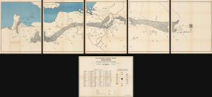
Operations from Omaha Beach to Elbe River.
$3,500.00
Acquire
- Digital Map Information
- Suitable for large format printing
- Full resolution TIFF file
- ICC color profile embedded
- Delivered instantly via download link
This monumental 1945 John A. LeDonne route map chronicles the 1115th Engineer Combat Group's advance across Europe during the final year of World War II (1939 - 1945). Among the largest and most elaborate American unit route maps, it follows the 1115th from Normandy through France, Belgium, and Holland and deep into Germany to the Elbe, recording command posts, dates, movements, and an extraordinary 100 bridge-building operations along the way. Punctuated by humorous and sometimes risqué pictorial vignettes recalling liberation, alcohol, romance, and the everyday experiences of American soldiers abroad, the map is at once a remarkable operational record and a vivid visual memoir of the 1115th's war across Europe. (more details)
Pimlico's social geography at the outset of WWII.
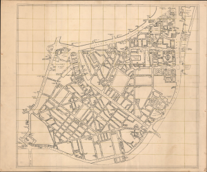
[Pimlico, London.]
$3,500.00
Acquire
- Digital Map Information
- Suitable for large format printing
- Full resolution TIFF file
- ICC color profile embedded
- Delivered instantly via download link
This is an exceptional c. 1939 manuscript map of Pimlico, London, capturing the social geography of wartime London just before the Blitz, German aerial bombing campaign against London and the rest of the United Kingdom. Uniquely, rather than emphasizing civil defense, it meticulously identifies the pubs, clubs, theaters, and nightlife that sustained morale in the shadow of grim war. The map's remarkable precision, suggestive of a military hand, leads us to believe it was prepared as a recreation guide for soldiers on leave, preserving a vibrant urban landscape that would soon be devastated during the Blitz of 1940-1941. (more details)
Planning Operation Hailstone - the World War II U.S. Navy attack on Truk Atoll.
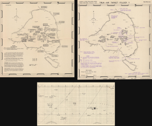
Truk Atoll. Major Fortifications. / Truk - Air Target Folder II. Truk Islands. Target Area Map - Truk Islands. / [Untitled Aviation Chart of the East Caroline Islands.]
$3,500.00
Acquire
- Digital Map Information
- Suitable for large format printing
- Full resolution TIFF file
- ICC color profile embedded
- Delivered instantly via download link
This important archive, compiled days after the World War II Battle of Kwajalein and weeks before Operation Hailstone, includes three 1944 U.S Navy maps of Truk Atoll (Chuuk Lagoon, Micronesia): two 1944 Joint Intelligence Center Pacific Ocean Areas (JICPOA) maps of Truk Atoll, and an aviation chart of the same. The map archive offers unique insights into the U.S. Navy's preparations to assault one of Japan's most formidable bases in the South Pacific. Truk Atoll was Imperial Japan's main naval base in the South Pacific, considered the 'Gibraltar of the Pacific'. (more details)
Nazi crimes near Kielce and Radom.
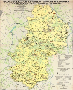
Walki z Najeźdźcą Hitlerowskim i Zbrodnie Hitlerowskie na Terenie Województw Kieleckiego i Radomskiego w Latach 1939 - 1945. Armed Struggle Against the Nazi Invader and Nazi Crimes in Kielce and Radom Voivodeships in the Years 1939 - 1945.
$3,500.00
Acquire
A chilling 1977 Polish wall map detailing Hitler's crimes and the fight against the invasion and occupation in the voivodeships of Kielce and Radom. It was published by Kielce's Provincial Citizens' Committee for the Protection of Monuments of Struggle and Martyrdom. It is ever more poignant in the light of modern revisionist historical research that has re-evaluated the Polish role in the Holocaust, as well as efforts by the current Polish government to legislate and control the historical record. All text on the piece is in Polish, Russian, English, French, and German. (more details)
Nazi crimes around Gdańsk during World War II.
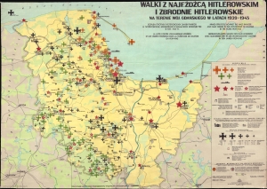
Walki z Najeźdźcą Hitlerowskim i Zbrodnie Hitlerowskie na Terenie Woj. Gdańskiego w Latach 1939 - 1945. Armed Struggle Against the Nazi Invader and Nazi Crimes in the Voivodeship of Gdańsk in the Years 1939 - 1945.
$3,500.00
Acquire
A chilling 1968 Polish wall map chronicling Hitler's war crimes and the fight against the invasion and occupation of the voivodeship of Gdańsk. It was published by the Provincial Citizens' Committee for the Protection of Monuments of Struggle and Martyrdom in Gdańsk. It is ever more poignant in the light of modern revisionist historical research that has re-evaluated the Polish role in the Holocaust, as well as efforts by the current Polish government to legislate and control the historical record. All text on this piece is in Polish, Russian, English, French, and German. (more details)
First city in Germany captured by the Allies.
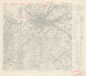
Aachen. German Defences Prepared by First U.S. Army APID. Sheet 5202.
$3,500.00
Acquire
- Digital Map Information
- Suitable for large format printing
- File Size: 21.43 MB
- File Type: ZIP / TIFF
- ICC color profile embedded
- Delivered instantly via download link
This is an October 1944 First U.S. Army military situation map of Aachen, Germany, illustrating the defenses around the city as observed from aerial photography. This map was produced only days before the soldiers of the U.S. Army stormed the city and, after three weeks, successfully captured the city from the Germans. Aachen was a strategically important city, but it held greater significance from a psychological perspective. The Holy Roman Emperor Charlemagne was born in Aachen, and Hitler and the Nazis referred to the Holy Roman Emperor as the First Reich. (Hitler referred to his empire as the Third Reich, thus creating a direct line between his regime and the Holy Roman Empire.) Aachen was the first city in Germany captured by the Allies, and this blow must have weighed heavily on Hitler's mind. (more details)
A glimpse into how WWII aviators were briefed before missions.
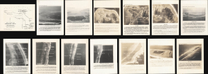
[Kwajalein Atoll Aerial Attack Archive.]
$2,500.00
Acquire
- Digital Map Information
- Suitable for large format printing
- Full resolution TIFF file
- ICC color profile embedded
- Delivered instantly via download link
This is a 1943-1944 intelligence archive prepared for the aerial campaign preceding the invasion of Kwajalein Atoll, offering unique insights into how American World War II aircrews were briefed for combat missions. Strategically located, Kwajalein was occupied and fortified by Imperial Japan early in the war and became a principal American objective in the Central Pacific. U.S. forces landed on Kwajalein and Roi-Namur on January 31, 1944, following months of reconnaissance and preparatory bombing. Comprising annotated aerial photographs, target maps, a manuscript planning overlay, and a regional aviation chart, this archive reveals how pilots moved from broad theater geography to the identification of individual airfields, warehouses, gun positions, and other tactical targets. (more details)
Bringing aerial destruction to Nazi-dominated Europe.
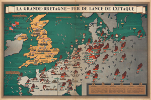
La Grande-Bretagne - Fer de Lance de l'Attaque.
$2,500.00
Acquire
- Digital Map Information
- Suitable for large format printing
- Full resolution TIFF file
- ICC color profile embedded
- Delivered instantly via download link
This is a 1943 F. Donald Blake French-language pictorial propaganda map of Great Britain and continental Europe at the height of World War II (1939 - 1945). The map's message is clear: the tide of war has turned, and British RAF forces are taking a heavy toll on Nazi-dominated Europe. (more details)
Cyanotype World War II route map!
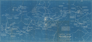
Graphical History of the 987th F.A. Battalion 155 MM Self Propelled Guns. Lt. Col. Wm. C. Smith, BN CO.
$2,500.00
Acquire
- Digital Map Information
- Suitable for large format printing
- DPI: 600
- File Size: 42.67 MB
- File Type: ZIP / TIFF
- ICC color profile embedded
- Delivered instantly via download link
This is a rare 1946 cyanotype World War II route map of the 987th Field Artillery Battalion in Europe, drawn by the battalion's commanding officer, Lieutenant Colonel William C. Smith. The map highlights moments throughout the 987th's campaign across Europe and provides snippets of the battalion's experiences in the war. This map is the only cyanotype route map we have encountered. Due to restrictions imposed by the cyanotyping process, this map was likely produced in a very small print run. (more details)
Small local Polish museums dedicated to local Polish history.
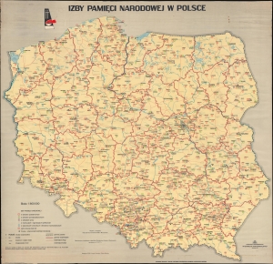
This is a 1977 Polish map of Poland highlighting Chambers of National Remembrance (Izby Pamięci Narodowej) across the country. These small museums, usually no more than a handful of rooms and sometimes only a single room, commemorate local history and collect artifacts that tell the stories of local citizens and their lives. Many of these are related to the Holocaust, but others deal with much less traumatic subjects. (more details)
Japan: A Grasping Octopus.
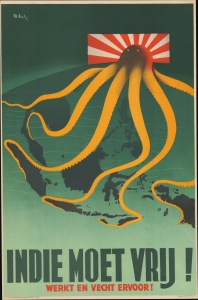
Indie Moet Vrij! Werkt en Vecht Ervoor! [The Indies Must Be Free! Work and Fight For It!]
$2,500.00
Acquire
- Digital Map Information
- Suitable for large format printing
- File Size: 25.05 MB
- File Type: ZIP / TIFF
- ICC color profile embedded
- Delivered instantly via download link
This powerful 1944 Patrick Cokayne Keely World War II propaganda image presents Japan as a menacing octopus with grasping tentacles extending throughout Southeast Asia, the Philippines, and the East Indies. (more details)
Exceptional large-format wartime Japanese map of the Philippines.
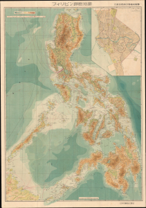
フィリピン詳密地圖 / Detailed Map of the Philippines. / Firipin shomitsu chizu.
$2,400.00
Acquire
- Digital Map Information
- Suitable for large format printing
- Full resolution TIFF file
- ICC color profile embedded
- Delivered instantly via download link
This is Kawamata Tetsuya's rare 1944 (Showa 19) Japanese large-format map of the Philippines, issued just 5 days after the WWII Philippines Campaign (1944 - 1945) began. The map is an expansion on a similar map issued for the 1942-43 'Greater East Asia Co-Prosperity Sphere' map series, which it stylistically resembles despite being four times the size. (See our listing coprosperityset-showa18-1943 for more detail on this series.) This map was issued to satisfy an increased Japanese need for information and reconnaissance following General Douglas MacArthur's landing at Leyte. (more details)
A complete set of 79th Infantry Division route maps from World War II - maps created by the soldiers for the soldiers.
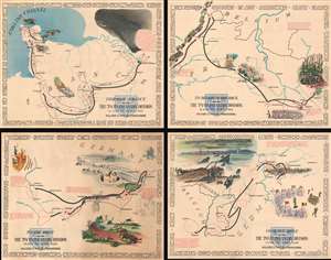
Through France with the 79th Infantry Division 14 June to 29 Aug, 1944. Maj Gen I.T. Wyche, Commanding. / To Belgium and Back wit the 79th Infantry Division 31 Aug to 25 Oct, 1944 Maj. Gen. I. T. Wyche, Commanding. / To the Rhine with the 79th Infantry Division 25 Oct to 14 Feb. 1945 Maj Gen I.T. Wyche, Commanding. / Over the Rhine with the 79th Infantry Division 17 Feb to 9 May 1945 Maj. Gen. I. T. Wyche, Commanding.
$2,200.00
Acquire
- Digital Map Information
- Suitable for large format printing
- Full resolution TIFF file
- ICC color profile embedded
- Delivered instantly via download link
This is a set of four Steve Kaliher and Harry D. White pictorial World War II route maps of the 79th Infantry's advance from Normandy to Germany. Presented on four separate sheets, a detailed summary of the division's progress across northern Europe from Utah Beach (one of the four Normandy beaches assaulted by Allied troops only eight days on what has become known as D-Day) to Mulheim, Germany. Each map traces a sequence of a few months in the combat history of the 79th with red lines labeled with dates marking the advance week by week and sometimes day to day. Text blocks narrate parts of the advance, providing insight into what the division accomplished during their over 300 days of combat. Cities and towns are identified throughout all four maps, as are rivers. Each map is framed by the names of cities and towns that the division passed through on their advance, fought for, and liberated, adding yet another level of memory to each piece. (more details)
Shanghai's French Concession amidst War.
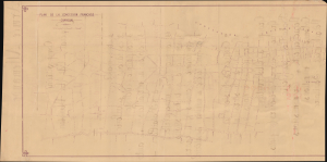
Plan de la Concession française Changhai.
$2,000.00
Acquire
- Digital Map Information
- Suitable for large format printing
- Full resolution TIFF file
- ICC color profile embedded
- Delivered instantly via download link
This is a large-format diazotype proof map of the Shanghai French Concession, produced by the Concession's administration in 1937, a period defined by the Battle of Shanghai (August 13 - November 26, 1937) and a refugee crisis. The verso is equally intriguing, though perhaps unrelated, and bears the handwritten Order of Battle of a German infantry division in French. (more details)
WWII Guadalcanal Campaign.
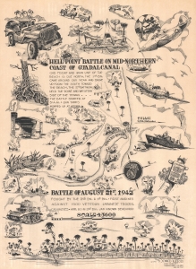
'Hell Point' Battle on Mid-Northern Coast of Guadalcanal. Battle of August 21, 1942.
$2,000.00
Acquire
- Digital Map Information
- Suitable for large format printing
- File Size: 23.62 MB
- File Type: ZIP / TIFF
- ICC color profile embedded
- Delivered instantly via download link
This is a 1943 Donald Moss pictorial map of the 1942 Battle of Hell's Point on Guadalcanal. Guadalcanal was the first American ground offensive in the Pacific and was a critical fight to stop the Japanese advance. (more details)
Reporting the war to Japan's home front.
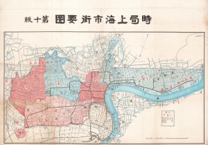
時局上海市街要圖 / [Current Situation Streetmap of Shanghai].
$2,000.00
Acquire
- Digital Map Information
- Suitable for large format printing
- File Size: 98.99 MB
- File Type: ZIP / TIFF
- ICC color profile embedded
- Delivered instantly via download link
This 1932 Teikoku Zaigō Gunjinkai map of Shanghai documents the 1932 Shanghai Incident (also known as the January 28 Incident), a brief war fought in the city between Japanese and Chinese forces. Although focusing on military forces, it also is a highly detailed street map or plan of Shanghai at the time, prepared with a Japanese audience in mind. (more details)
Manuscript map related to German U-Boat Commander in World War II.
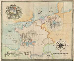
Kapitanleutnat Bitter gewindmet vom Soldatenheim Rochefort November 1943. / Zur Beförderung Gratulirf Der Schwesterntisch.
$2,000.00
Acquire
- Digital Map Information
- Suitable for large format printing
- File Size: 7.07 MB
- File Type: ZIP / TIFF
- ICC color profile embedded
- Delivered instantly via download link
This is a charming 1943 manuscript map of Europe was drawn to celebrate the promotion of the German World War II Kriegsmarine officer Kapitänleutnant Georg von Bitter to U-Boat Commander. Drawn in a whimsical manuscript style, with stylistic elements drawn from ... (more details)
The Allies' 'Trampoline to Victory'
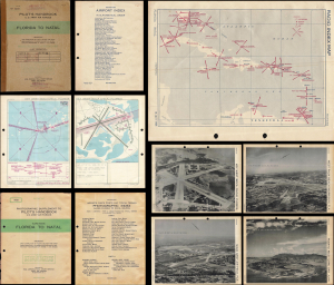
Pilot's Handbook U.S. Army Air Forces Florida to Natal / Photographic Supplement to Pilot's Handbook U.S. Army Air Forces Along Route Florida to Natal.
$1,950.00
Acquire
This is a rare 1945 restricted / confidential pilot's handbook and photographic supplement prepared by the U.S. Army Air Force's Aeronautical Chart Service. Containing several dozen aeronautical charts and photographs of airfields, it guided pilots along the World War II-era South Atlantic route that ferried supplies from Florida, over the Caribbean, to Brazil, across the Atlantic Ocean, and finally to Allied armies in the field. (more details)
Smash the Swastika.
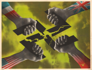
U.S.P.F. II
$1,800.00
Acquire
- Digital Map Information
- Suitable for large format printing
- File Size: 33.57 MB
- File Type: ZIP / TIFF
- ICC color profile embedded
- Delivered instantly via download link
This is Frederick Henri Kay Henrion's striking c. 1944 anti-Nazi poster produced during the Allied counter-offensive against Germany during World War II (1939 - 1945). Although emphasizing unity among the Allies, it also subtly hints at underlying tensions. (more details)
A Particular Take of Poland's Experience of World War II.
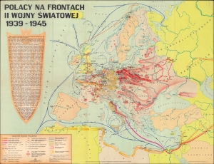
This is a 1971 Państwowe Przedsiębiorstwo Wydawnictw Kartograficznych map of Europe displaying the battles of the Polish nation against Nazi Germany during the Second World War. On a per capita basis, Poland suffered more than any other country during the war, losing some 17 percent of its 1939 population in the conflict (including millions of Jews killed in the Holocaust). (more details)
Celebrating the Japanese victory at Pearl Harbor.
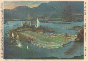
Hawaii Ocean Battlefield Map. / ハワイ大海戦圖
$1,800.00
Acquire
- Digital Map Information
- Suitable for large format printing
- File Size: 29.9 MB
- File Type: ZIP / TIFF
- ICC color profile embedded
- Delivered instantly via download link
A rare World War II Japanese view propagandizing the December 7, 1941 attack on Pearl Harbor, Hawaii. The view, by the artist Matsushima, was issued on December 10, 1941 (Showa 16), just three days after the fateful attack which precipitated U.S. involvement in World War II (1939 - 1945). Looking over the naval base at Ford Island (Pearl Harbor) and 'Battleship Row' from an elevated position northwest of the Island, it is based upon a famous photo taken from a Japanese plane during the attack. Japanese fighter and bomber planes fill the sky and U.S. battleships appear in ruins while the naval port burns. (more details)
Slovak WWII propaganda to crush Nazi Germany.
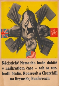
Nácistické Nemecko bude dobité v najkratšom čase - tak sa rozhodli Stalin, Roosevelt a Churchill na krymskej konferencii.
$1,800.00
Acquire
- Digital Map Information
- Suitable for large format printing
- File Size: 41.22 MB
- File Type: ZIP / TIFF
- ICC color profile embedded
- Delivered instantly via download link
This is a powerful 1945 Slovak-language Soviet World War II propaganda poster heralding the achievements of the Yalta Conference and the Allies' agreement to continue the fight until Germany was defeated. The evocative image set against a bright yellow background features three fists (representing the United States, the United Kingdom, and the Soviet Union) punching a dejected and depressed Hitler. A Nazi swastika is breaking apart in the background. The text reads, 'Nácistické Nemecko bude dobité v najkratšom čase - tak sa rozhodli Stalin, Roosevelt a Churchill na krymskej konferencii' ('Nazi Germany will be conquered in the shortest possible time - this is what Stalin, Roosevelt, and Churchill decided at the Crimean conference'). (more details)
Australia Remade by World War II.
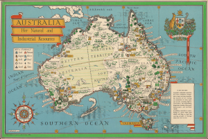
Australia Her Natural and Industrial Resources.
$1,600.00
Acquire
- Digital Map Information
- Suitable for large format printing
- File Size: 34.09 MB
- File Type: ZIP / TIFF
- ICC color profile embedded
- Delivered instantly via download link
This is a colorful 1942 pictorial map of Australia prepared by MacDonald Gill, a pioneer of the genre. Produced in the early phase of the Pacific War (1941 - 1945) against Imperial Japan, part of World War II (1939 - 1945), the map focuses on Australia's resources, which would prove critical to winning the war. (more details)
Last Days of Japan's Occupation of Hong Kong
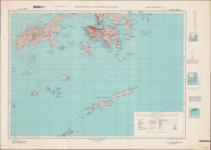
Hong Kong and Lema Islands. South Sheet. Second Edition - AMS 3.
$1,500.00
Acquire
- Digital Map Information
- Suitable for large format printing
- Full resolution TIFF file
- ICC color profile embedded
- Delivered instantly via download link
This is a 1945 Army Map Service map of Hong Kong, produced in the closing days of World War II. By this time, Hong Kong had suffered through nearly four years of starvation and oppression under Japanese occupation. (more details)