
Korean Maps
'A masterpiece designed to give a general picture of the Old and New' - Old Maps of Korea
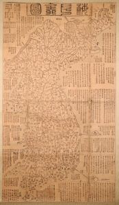
海左全図 [Haezwa Jeon-do / Map of the Country in the West of the Sea.]
$22,000.00
Acquire
- Digital Map Information
- Suitable for large format printing
- Full resolution TIFF file
- ICC color profile embedded
- Delivered instantly via download link
A rare discovery, this c. 1850 woodblock map is one of the few early Korean maps of Korea to be found outside of Korea. It is significant on many levels, being a record of Korea following the reign of King Sunjo (조선 순조; 1790 - 1834), a period when Korea was facing increased pressure from foreign powers, including Japan, Russia, and China. It is also significant for illustrating Korea's disputed island, Dokdo. (more details)