
Baur, Carl Fredrich

Carl Fredrich Baur (fl. c. 1850 - 1900) was a German map publisher active in Stuttgart during the mid to late 19th century. Baur was little known outside of Germany but nonetheless produced a number of important map most of which had a thematic or historic context. His most notable work is most likely the 1857 Atlas fur Handel und Industrie fur Kaufleute, Fabrikanten und Gewerbetreibende, one of the first industrial and commercial atlases of the 19th century.
Balancing Out the Balkans.
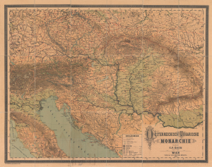
Oesterreichisch Ungarische Monarchie.
$1,000.00
Acquire
- Digital Map Information
- Suitable for large format printing
- File Size: 223.67 MB
- File Type: ZIP / TIFF
- ICC color profile embedded
- Delivered instantly via download link
This is a massive (56 x 70.5 in.) folding wall map of the Austro-Hungarian Empire, prepared in 1882 by Carl Friedrich Baur. It depicts the lands of the Dual Monarchy in the aftermath of the 1878 Congress of Berlin, which saw Austria-Hungary occupy Bosnia and Herzegovina as part of a coordinated effort to limit Russian influence in the Balkans. (more details)