
Brown, Glen Francis

Glen Francis Brown (December 14, 1911 - February 27, 2001) was an American geologist at the U.S. Geological Survey who is best known for leading a years-long USGS effort to survey the geology, hydrology, and mineral resources of the Kingdom of Saudi Arabia, concurrent with most of the Arabian Peninsula. Brown was born in Graysville, Indiana and attended college at New Mexico School of Mines before receiving a master's degree and doctorate at Northwestern University. He began working with the USGS in 1938 and was posted to projects in different parts of the U.S. before being selected to explore water resources on the Arabian Peninsula, the result of a request by King Abdulaziz to the USGS. He undertook further explorations in Saudi Arabia on agricultural possibilities and geologic formations before completing his doctorate and being posted to Thailand for a geological and mineral reconnaissance. But in 1950, Brown was requested by King Abdulaziz to return to Saudi Arabia to lead an ambitious project, in conjunction with the Arabian-American Oil Company (Aramco), to survey the water and mineral resources of the entire kingdom. These maps would play a key role in the future economic and infrastructural development of the kingdom. Brown remained in Saudi Arabia for most of the following twenty years, leading the joint USGS-Saudi project until 1969, and remained a consultant residing in Jeddah until returning to the U.S. in 1972 and retiring, though remaining a key expert on Saudi Arabia's geology, geography, and tectonics.
One of the Most Successful Partnerships in History.
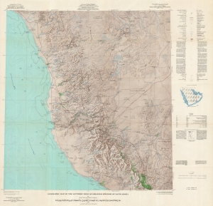
Geographic Map of the Southern Hijaz Quadrangle, Kingdom of Saudi Arabia Miscellaneous Geologic Investigations Map I-210B. / [خريطة جغرافية للوحة الحجاز الجنوبي بالمملكة العربية السعودية ابحاث جيولوجية مختلفة ؛ خريطة رقم I 210B].
$2,000.00
Acquire
A remarkable map of the southern portion of the Hijaz (Hejaz, ٱلْحِجَاز), Saudi Arabia - includding Mecca / Mekkah. This map was prepared by Glen F. Brown and Roy O. Jackson of the U.S. Geological Survey in 1958 for the oil conglomerate Saudi Aramco, then updated with information to 1968. It represents one part of a special partnership between the USGS and Aramco that has helped make the latter among the largest and most profitable corporations in the world. (more details)