
Daussy, Pierre

Pierre Daussy (October 8, 1792 - September 5, 1860) was a French astronomer and hydrographic engineer with the Bureau des Longitudes and later the Dépôt des Cartes et Plans de la Marine, which he led as Director in the years prior to his death. Daussy was born in Paris, the son of hydrographer Magloire Thomas Daussy (1758 - 1826). He followed in his father's footsteps, studying at the École des Ingénieurs Hydrographes before undertaking hydrographic work in the North Sea under the command of Charles-François Beautemps-Beaupré. He graduated to the rank of engineer in 1819 and chief engineer in 1829. In 1833, he began work with the Bureau des Longitudes correcting the French Table des Positions Géographiques des Principaux Lieux du Globe to conform with the most recent measurements made possible by new hydrographic instruments and methodologies. He was elected Director of the Dépôt des Cartes et Plans de la Marine in 1855. He also served as the President of the Société de Géographie de Paris in his later years and published several works on hydrography and navigation, particularly relating to the coasts of the Ottoman Empire and Persia.
Early, gorgeous chart of the East Indies.
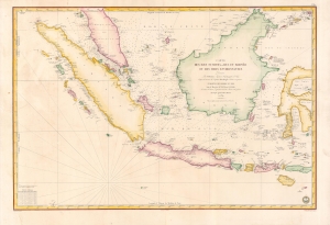
Carte des Iles Sumatra, Java et Borneo et des mers Environnantes...
$1,000.00
Acquire
- Digital Map Information
- Suitable for large format printing
- Full resolution TIFF file
- ICC color profile embedded
- Delivered instantly via download link
A beautiful and rare 1839 French Depot-General de la Marine nautical chart or maritime map of the East Indies or Insular Southeast Asia - including Singapore. The size and level of detail is impressive, reflecting the importance of the chart as representing the pinnacle of hydrographical knowledge at the time. (more details)
French colonial interest in the Philippines. Also, rectification of charts.
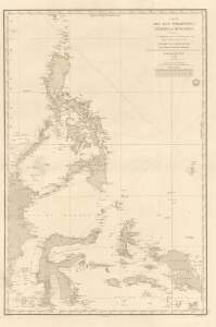
Carte des Iles Philippines, Célèbes et Moluques.
$4,500.00
Acquire
- Digital Map Information
- Suitable for large format printing
- Full resolution TIFF file
- ICC color profile embedded
- Delivered instantly via download link
A spectacular 1840 / 1852 map of the Philippines by Pierre Daussy and the French Dépot-général de la Marine. This map is significant as it reflects growing French interest in the Far East and coincides with the first French attempt to seize the Philippine island of Basilan as a base to counterbalance British power in Hong Kong. It is also part of the French Bureau des Longitudes' ongoing effort to revise its Table des Positions Géographiques des Principaux Lieux du Globe to conform to the most up-to-date measurements made possible by advances in hydrography, including widespread early 19th century adoption in the marine chronometer. Daussy published dozens of new charts, including this one, to reflect the significant corrections. (more details)
Challenging British Hegemony in the Indian Ocean.
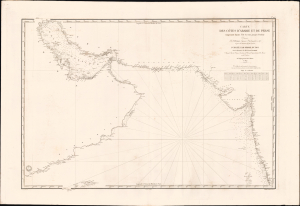
Carte des côtes d'Arabie, et de Perse, comprenant depuis l'Ile Socotra jusqu'à Bombay.
$2,500.00
Acquire
- Digital Map Information
- Suitable for large format printing
- File Size: 39.57 MB
- File Type: ZIP / TIFF
- ICC color profile embedded
- Delivered instantly via download link
This is a rare, large-format 1840 nautical chart of the Arabian Sea and Persian Gulf prepared by the French Dépôt Général de la Marine. At the time it was produced, France was trying to match Britian's growing dominance of the Indian Ocean, presenting itself to indigenous rulers as an alternative trading partner. (more details)