
Grimm, Julius Ludwig

Julius Ludwig Grimm (November 2, 1806 - January 17, 1834) was a German cartographer active in Berlin in the early 20th century. Grimm was born in Wetzlar, Hesse, Germany. Little is known of his life or education, but he worked under Heinrich Berghaus (1797 –1884) and later Carl Ritter (1779 - 1859), on parts of his monumental Erdkunde im Verhältnis zur Natur und zur Geschichte des Menschen oder allgemeine, vergleichende Geographie, als sichere Grundlage des Studiums und Unterricts in physicalischen und historischen Wissenschaften. In 1832, he founded his own publishing house together with the engraver Wilhelm Scharrer, with whom he published a pneumatic (inflatable) globe. Unfortunately, fate ended the career of an otherwise promising young mapmaker and he died shortly thereafter in 1834.
Speculation on the Transhimalaya.
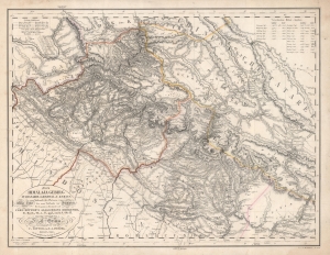
Das Himálaja Gebirg in Bissahir, Gherwal und Kemaun, von Südrande des Plateaus von Mittel-Tibet biz zum Tieflande von Hindostan.
$975.00
Acquire
- Digital Map Information
- Suitable for large format printing
- DPI: 600
- File Size: 56.07 MB
- File Type: ZIP / TIFF
- ICC color profile embedded
- Delivered instantly via download link
This is Carl Ritter and Julius Ludwig Grimm's 1833 map of parts of the Himalayas, the Tibetan Plateau, Nepal, Uttar Pradesh, Uttarakhand, and Dera Dun. This map was compiled at a time when Europeans knew little of this region, and so, this map is a dense amalgam of explorers' accounts and speculation expounded through the lens of Ritter's German Romantic theories of the Earth as a 'cosmic individual'. The work is novel as Ritter correctly deduced that the Transhimalaya is the eastern continuation of the Karkorum system. (more details)