
Hunt, C. E.

C. E. Hunt (fl. c. 1941 - 1967) was a cartographer active in Silicon Valley in the mid-20th century. Hunt mostly produced maps of nearby communities for the Palo Alto Chamber of Commerce.
Early Days of Silicon Valley.
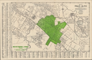
Map of Palo Alto and Vicinity Compiled from Official Records of Santa Clara and San Mateo Counties.
$350.00
Acquire
- Digital Map Information
- Suitable for large format printing
- Full resolution TIFF file
- ICC color profile embedded
- Delivered instantly via download link
A detailed c. 1953 city plan or map of Palo Alto and surrounding communities, including Stanford, Los Altos, Atherton, and Menlo Park. It was prepared by C. E. Hunt and printed by Slonaker's Printing House for the Palo Alto Chamber of Commerce. (more details)