
Jerusalem Institute of Photogrammetry (מכון לפוטוגרמטריה)

Jerusalem Institute of Photogrammetry (מכון לפוטוגרמטריה; c. 1948 - 1965) was an Israeli cartographic firm specializing in the process of photogrammetry, in which overlapping photographs are used to produce highly-accurate maps and models. The company was founded and led by surveyor Zalman Lif (זלמן ליף), an advisor on geographical issue to David Ben-Gurion and other Israeli leaders, until his death in October 1950, after which his son Nimrod (נמרוד ליף) took over the company (incidentally, Nimrod's son Yanaam (ינעם ליף) is a well-known Israeli composer). The company was under the technical direction of Major Alexander Glick (מייג'ור אלכסנדר גליק), who had led the Palestine Surveyors Company of the British Army during World War II. (Many veterans of this unit would eventually serve in the Israel Defense Forces, with some also aiding the anti-British Haganah in the years prior to Israel's independence.)
AKA: מכון לפוטוגרמטריה
Development of West Jerusalem.
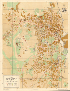
This is a 1958 Hebrew-language pictorial map of West Jerusalem, prepared by the Jerusalem Institute of Photogrammetry. Intended to highlight the city's bus lines, it also serves as a reminder of the ad hoc boundaries that divided the city in the wake of the First Arab-Israeli War. (more details)