
Llobet, Francisco

Francisco Llobet (1705 - December 5, 1785), also spelled Llovet, was a Spanish military engineer, civil engineer, and architect. He was born in Perpignan, France. Llobet volunteered for the Cuerpo de Ingenieros Militares (Corps of Military Engineers) at just 15. In this capacity he attended the Academia Militar de Barcelona. After graduating, in 1725, he was sent to Oran and then to the Army of Italy where he fought during the War of the Polish Succession (1733 - 1738). In his role as a military engineer, he prepared pre-battle plans of Messina and Syracuse. He then joined the Army of Lombardy for the siege of Mirandola and the blockade of Mantua. He constructed fortifications at Ciduad Rodrgio, Portugal. He Galicia, he directed the construction of the Ferrol Arsenal. Moving on to civilian works, he planned the neighborhood of Magdalena in Ferrol, Galicia. In 1765, he planned the military expansions of Santander. In 1770, he was assigned to Cartagena. Accompanied by his son Rafael, who was serving as assistant engineer, he was assigned to the renovation of the Plaza de Cartagena, but was soon dismissed from the position due to political infighting. He became Director de Ingenieros del Principado de Cataluña in 1774, holding the position until 1784, when he retired due to old age and declining health. He died a year later in 1785.
Precursor to the Catastro.
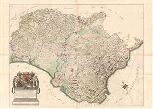
Mapa del Reynado de Sevilla executado por el Ingenioro en Geje Dn. Francisco Llobet.
$2,500.00
Acquire
- Digital Map Information
- Suitable for large format printing
- DPI: 600
- File Size: 92.56 MB
- File Type: ZIP / TIFF
- ICC color profile embedded
- Delivered instantly via download link
An exceptional 1748 wall map of the Kingdom of Sevilla or Seville, Spain, by Francisco Llobet. Coverage extends from the Guadiana River, or Odiana, which forms the western border of Sevilla and Portugal, to the border with Granada, and from Extremadura and Cordova to the Gulf of Cádiz. It is large, with meticulous detail, illustrating towns, villages, and roads. Some effort is made to further illustrate terrain, distinguishing between developed agricultural lands, mountains, marshy terrain, lowland plains, and forests. A dramatic cartouche in the lower left takes the form of a Romanesque plinth, surmounted by the royal arms of King Ferdinand VI (1713 - 1759). (more details)