
Maerschalk, Francis

Francis Maerschalk (1704? - 1776) held a long tenure as City Surveyor in colonial New York, of which city he appeared to have been a native. Nothing is known of his early life and instruction; he became a member of New York's Dutch Reformed congregation on August 21, 1723; he was married at that church to Anneke Lynsse on April 22, 1727. He was appointed City Surveyor in 1733. Between 1744 and 1754, he executed the surveys that would be incorporated in the so-called Maerschalk Plan of New York, which was published by Gerardus Duyckinck in 1755. Heis understood to have surveyed the Blooomingdale Road in 1760, and performed many commercial and civic surveys of other specific areas of the city. His plan of the city is the only printed work attributed to him.
New York Builds to its Limits, Before Removing Its Limits.
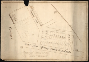
(On Verso) Land on Chatham Street Surveyed by Fran. Maerschalk 1757.
$3,000.00
Acquire
- Digital Map Information
- Suitable for large format printing
- DPI: 600
- File Size: 48.56 MB
- File Type: ZIP / TIFF
- ICC color profile embedded
- Delivered instantly via download link
This is an early 19th-century manuscript map of the City Hall Park area, New York City. It is an early 19th-century copy of a 1759 survey by Francis Maerschalk detailing the future City Hall Park and the area directly to the southeast. The survey fits into a gap in the mapping of the city between the 1755 Maerschalk plan and the 1760s plans of Montresor and Ratzer. (more details)