
Saito Katsuzo (財藤勝藏)

Saitō Katsuzō (財藤勝藏; fl. c. 1906 - 1928), also written as 戝藤勝藏, was a cartographer and publisher of the late Meiji and Taisho eras based in Osaka. His works aligned perfectly with Japan's growing imperial ambitions at the time, primarily focusing on Korea and Manchuria. He was closely associated with the publishing house Jūjiya (十字屋), of which he may have been a propoerietor.
AKA: 財藤勝藏
Scarce large format map of Dalian, China.
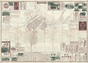
大連市街全圖 / [Complete Street Map of Dalian / Dairen].
$900.00
Acquire
- Digital Map Information
- Suitable for large format printing
- Full resolution TIFF file
- ICC color profile embedded
- Delivered instantly via download link
This is Saito Katsuzō's unrecorded, large-format 1910 city map or plan of Dalian, or Dairen, documenting the port's early development as Japan's commercial springboard into Manchuria. Published five years after Japan acquired Russia's leasehold rights following the Russo-Japanese War (1904 - 1905), it combines a detailed street and property plan with railway timetables, extensive business advertising, and a photographic panorama on the verso. Its advertisements connect Dalian with businesses in Japan and with inland centers such as Harbin, revealing commercial relationships that extended beyond the boundaries of the Japanese-administered Kwantung Leased Territory, setting the stage for further Japanese expansion into Manchuria in the following years. (more details)