
Toms, William Henry

William Henry Toms (1701 - 1765) was an English engraver, print seller, publisher and stationer active in London during the early to middle 18h century. The son of Peter Toms, Henry apprenticed under John Harris from 1716. He was engraving independently from at least 1726 and his imprint appears on portraits, books plates, landscapes, maps and architectural prints. His name appears on the great Popple map of North America as well as on important maps by Lempriere, Seale, Boulton, Moll, and others. He was imprisoned for debt in 1761. His son, Peter Toms II (1726 - 1777) became a well known painter. His apprentices included the engraver and publisher John Boydell (January, 19 1720 - December 12, 1804). He lived on Masham Street, London. His work also appears as 'Henry William Toms', 'W. H. Toms', and 'Thoms'.
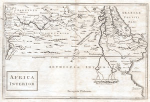
Africa Interior
$230.00
Acquire
- Digital Map Information
- Suitable for large format printing
- DPI: 300
- File Size: 1.56 MB
- File Type: ZIP / TIFF
- ICC color profile embedded
- Delivered instantly via download link
A very curious map of central Africa dating to approximately 1730. Covers the mid-section of Africa roughly from the Gulf of Guinea and the Atlantic eastward to the Red Sea and the horn. Extends southward as far as modern day Tanzania. Full of curious and ... (more details)
First scientific hydrographic survey of Bermuda.

To his Excellency Alured Popple Esq. Governour of Bermuda, or the Summer Islands This Map From a new Survey, Correcting ye Dangerous Errors in all ye Charts of that Place hitherto Published is Humbly Dedicated by C. Lempriere, and W. H. Toms, 1738.
$22,500.00
Acquire
- Digital Map Information
- Suitable for large format printing
- File Size: 20.39 MB
- File Type: ZIP / TIFF
- ICC color profile embedded
- Delivered instantly via download link
A holy grail of Bermuda map collecting, this is the 1738 first-edition first-state of Clement Lemprière's separately and independently published map of Bermuda. It is considered the first scientifically verified hydrographic survey of Bermuda and the first published map to correctly identify the archipelago's longitude. It surpassed and superseded the 17th-century Arent Roggeveen survey, thus becoming the basis for most subsequent maps of the archipelago until the Hurd surveys (1783-97). (more details)