
Basilicata, Francesco

Francesco Basilicata (???? – c. 1640) was a 17th century Italian cartographer and military engineer. Basilicata worked in the service of the Republic of Venice and is known for his maps and drawings of the island of Crete. Little is known of his early life, but it has been suggested that he may have been from Palermo. He lived in Crete during the first two decades of 17th century, in the last days of Venetian hegemony over the island. Basilicata fell in love with the island's rugged scenery and spent the years between 1612 and 1629 meticulously mapping the entire island. His maps of Crete from the foundation for must subsequent maps until the early 18th century.
Create and the fate of Europe.
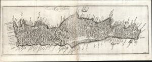
Carta del Regno di Candia.
$750.00
Acquire
- Digital Map Information
- Suitable for large format printing
- File Size: 18.53 MB
- File Type: ZIP / TIFF
- ICC color profile embedded
- Delivered instantly via download link
This elegantly engraved, scarce 1674 map of Crete was engraved in Vienna by Gaspar Bouttats after the 1651 map of Marco Boschini. The map captures the island at a crucial historic moment during the Cretan War (1645 - 1669), when the fate of Europe revolved around Crete. (more details)