
Hardee, Thomas Sydenham

Thomas Sydenham Hardee (1832 - 1880) was a cartographer and civil engineer based in New Orleans who primarily produced maps of his home city. He appears to have produced military maps for the Confederacy during the Civil War before shifting focus to maps of New Orleans and its surroundings in peacetime. On an 1876 report on the waters of Lake Pontchartrain and the Bonnet Carré Spillway he is listed as the 'City Surveyor,' a position he appears to have held for several years.
Reconstruction-era New Orleans.
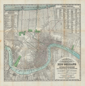
Topographical and drainage map of New Orleans and surroundings, from recent surveys and investigations.
$4,000.00
Acquire
- Digital Map Information
- Suitable for large format printing
- File Size: 36.39 MB
- File Type: ZIP / TIFF
- ICC color profile embedded
- Delivered instantly via download link
A detailed 1878 city plan or map of New Orleans and surrounding communities by civil engineer and city surveyor Thomas Sydenham Hardee. It is considered the most accurate map of the city to that date. While including comprehensive information on the city's streets, parks, railways, and more, it also focuses on the system of waterways, canals, and levees designed to prevent flooding and disease. (more details)