This item has been sold, but you can get on the Waitlist to be notified if another example becomes available, or purchase a digital scan.

1635 Blaeu Map Guiana, Venezuela, and El Dorado

Guiana-blaeu-1635
$400.00
Gviana siue Amazonvm Regio. - Main View
Processing...

1635 Blaeu Map Guiana, Venezuela, and El Dorado

Guiana-blaeu-1635

Rare 17th century map showing the route to El Dorado.

Title


Gviana siue Amazonvm Regio.
  1635 (undated)     15 x 20 in (38.1 x 50.8 cm)

Description


This is G. Blaeu's remarkable c. 1635 map of the northwestern parts of South America , Lake Parima (Parime Lacus), and the route to El Dorado. Blaeu initially issued this map in 1630 and variants were published well in to the 1660s. This example dates to the 1635 German edition of Blaeu's atlas. The map covers from Isla Margarita and the Orinoco Delta eastward as far as Tampico and southwards as far as the Amazon River.

This region of South America generated considerable European interest in the early 17th century following the publication of Sir Walter Raleigh's fascinating 'Discovery of the Large, Rich, and Beautiful EMPIRE Of GUIANA .' Raleigh's expedition traveled down the Orinoco River in search of the Kingdom of El Dorado. Today we know that El Dorado did not exist, but was rather an amalgam of very real tribal traditions and the European lust for gold. Nonetheless, in the 16th century, tales of El Dorado were common conversation along the port cities of the Spanish Main. Having explored a considerable distance down the Orinoco, Raleigh's expedition found itself mired in a remote tribal village at the onset of the rainy season. While waiting for an opportunity to return north, a trading delegation arrived. At this time the dominate trading empire in the Amazon were the Manoa, who, though based near modern day Manaus, pursued trade routes to from the foothills of the Andes to the Amazon and Orinoco Deltas. While the rainy season prevented Raleigh from moving forward, for the Manoa it had the opposite effect. The heavy rains inundated the vast Parima flood plain creating a great inland sea, consequently opening an important trade connection between the Amazon and Orinoco Rivers. When the Manoa arrived, Raleigh and his men noticed that they had various golden trinkets for sale. This was apparently enough for Raleigh to deduce that they must indeed be from the hidden kingdom of El Dorado. When Raleigh asked where the traders came from, the locals, with no common language with which to engage Raleigh, could only explain that they traveled across a great water and were from Manoa. Raleigh's presumptuous narrative inspired many early cartographers to map this massive lake, with the city of El Dorado or Manoa on its shores, in the unexplored lands between the Orinoco and Amazon River basins.

In addition to Blaeu's fascinating depiction of Lake Parima, among the most prominent such in any mapping of this region, there are also a number of attractive decorative elements. Three sailing ships ply the waters and just under the compass rose a scary looking sea monster swims toward shore. A decorative baroque title cartouche appears in the upper right quadrant and, at the bottom of the map, to small cartouches frame a distance scales and Blaeu's signature. Uncolored as issued.

Cartographer


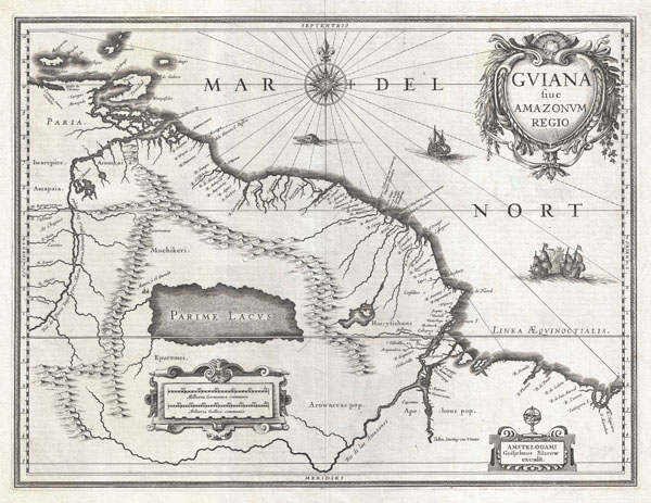
Willem Janszoon Blaeu (1571 - October 18, 1638), also known as Guillaume Blaeu and Guiljelmus Janssonius Caesius, was a Dutch cartographer, globemaker, and astronomer active in Amsterdam during the late 16th and early 17th centuries. Blaeu was born 'Willem Janszoon' in Alkmaar, North Holland to a prosperous herring packing and trading family of Dutch Reformist faith. As a young man, he was sent to Amsterdam to apprentice in the family business, but he found the herring trade dull and instead worked for his cousin 'Hooft' as a carpenter and clerk. In 1595, he traveled to the small Swedish island of Hven to study astronomy under the Danish Enlightenment polymath Tycho Brahe. For six months he studied astronomy, cartography, instrument making, globe making, and geodesy. He returned to Alkmaar in 1596 to marry and for the birth of his first son, Johannes (Joan) Blaeu (1596 – 1673). Shortly thereafter, in 1598 or 1599, he relocated his family to Amsterdam where he founded the a firm as globe and instrument makers. Many of his earliest imprints, from roughly form 1599 - 1633, bear the imprint 'Guiljelmus Janssonius Caesius' or simply 'G: Jansonius'. In 1613, Johannes Janssonius, also a mapmaker, married Elizabeth Hondius, the daughter of Willem's primary competitor Jodocus Hondius the Elder, and moved to the same neighborhood. This led to considerable confusion and may have spurred Willam Janszoon to adopt the 'Blaeu' patronym. All maps after 1633 bear the Guiljelmus Blaeu imprint. Around this time, he also began issuing separate issue nautical charts and wall maps – which as we see from Vermeer's paintings were popular with Dutch merchants as decorative items – and invented the Dutch Printing Press. As a non-Calvinist Blaeu was a persona non grata to the ruling elite and so he partnered with Hessel Gerritsz to develop his business. In 1619, Blaeu arranged for Gerritsz to be appointed official cartographer to the VOC, an extremely lucrative position that that, in the slightly more liberal environment of the 1630s, he managed to see passed to his eldest son, Johannes. In 1633, he was also appointed official cartographer of the Dutch Republic. Blaeu's most significant work is his 1635 publication of the Theatrum orbis terrarum, sive, Atlas Novus, one of the greatest atlases of all time. He died three years later, in 1638, passing the Blaeu firm on to his two sons, Cornelius (1616 - 1648) and Johannes Blaeu (September 23, 1596 - December 21, 1673). Under his sons, the firm continued to prosper until the 1672 Great Fire of Amsterdam destroyed their offices and most of their printing plates. Willem's most enduring legacy was most likely the VOC contract, which ultimately passed to Johannes' son, Johannes II, who held the position until 1617. As a hobbyist astronomer, Blaeu discovered the star now known as P. Cygni. More by this mapmaker...

Source


Blaeu, G., Atlantis Appendix, sive pars altera, continens tab. geographicas diversarum Orbis regionum, 1630.    

Condition


Very good condition. Original centerfold. German language text on verso.

References


Van der Krogt, Peter, Koeman's Atlantes Neerlandici, Vol. II, entry Bl 1, pp.73-75.