
Amerman, Richard

Richard Amerman (September 1, 1824 - October 6, 1893), sometimes spelled Ammerman, was a New York based surveyor and lawyer active in the late 19th century. Amerman was born in New York City. He was drafted in New York to fight in the American Civil War. In the 1870s, Amerman partnered with another city surveyor, Francis W. Ford (1846 - 1904), who he trained from 1864, to compile and publish cadastral property maps of New York - a lucrative profession in a time when old estates were being seized under eminent domain and redeveloped into property lots. When Amerman died in 1893, Ford took over the business, running it under his own name. Amerman is buried in Greenwood Cemetery, Brooklyn.
Rare cadestral map of New York City's Spanish Harlem.
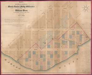
Maps of the Estates of Morris Randel, Philip Milledoler and William Wood, in the Twelfth (Formerly Ninth) Ward of the City of New York.
$1,500.00
Acquire
- Digital Map Information
- Suitable for large format printing
- File Size: 35.3 MB
- File Type: ZIP / TIFF
- ICC color profile embedded
- Delivered instantly via download link
A rare cadastral or property map of northeastern Manhattan, New York City, between Second Avenue and the Harlem River, and from 113th to 125th Streets. This area is today generally considered part of Spanish Harlem. The map employs color coding to define the limits of the former estates belonging to the Swiss-American Philip Milledoler (September 22, 1775 – September 22, 1852, 5th president of Rutgers College/University), William Wood (1777 - 1857, businessman), and Morris A. Randel. (more details)