1874 Amerman and Ford Map of The Upper East Side, 114th to 125th, New York City
4-RandelMilledolerWood-miller-1874$1,500.00

Title
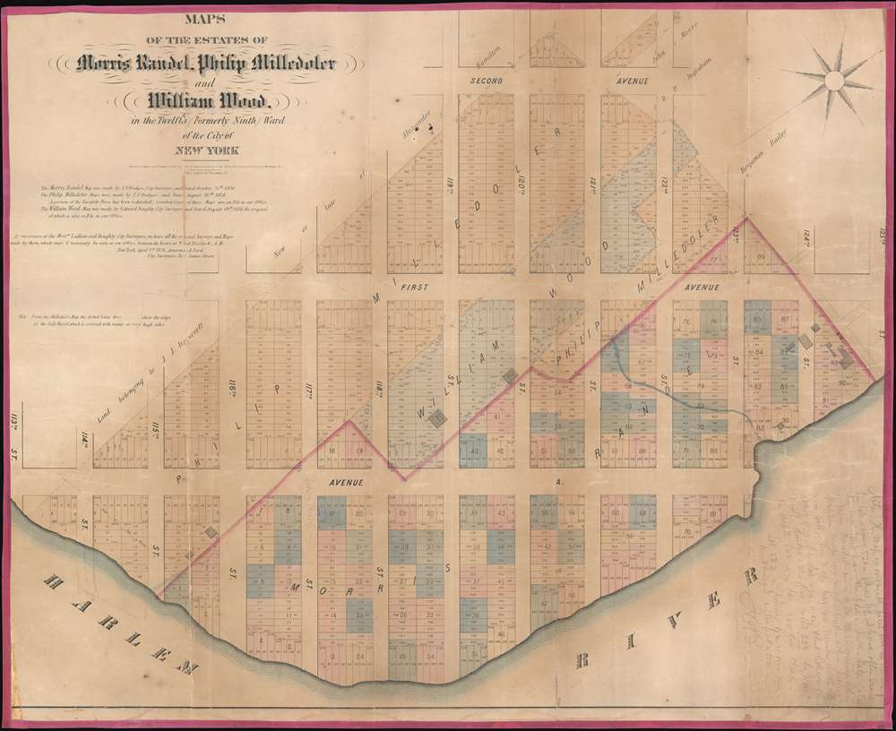
Maps of the Estates of Morris Randel, Philip Milledoler and William Wood, in the Twelfth (Formerly Ninth) Ward of the City of New York.
1874 (dated) 26.25 x 32 in (66.675 x 81.28 cm)
1874 (dated) 26.25 x 32 in (66.675 x 81.28 cm)
Description
A rare cadastral or property map of northeastern Manhattan, New York City, between Second Avenue and the Harlem River, and from 113th to 125th Streets. This area is today generally considered part of Spanish Harlem. The map employs color coding to define the limits of the former estates belonging to the Swiss-American Philip Milledoler (September 22, 1775 – September 22, 1852, 5th president of Rutgers College/University), William Wood (1777 - 1857, businessman), and Morris A. Randel.
Certain enterprising surveyors and mapmakers, most notably John Bute Holmes, but also as here Amerman and Ford, became fascinated by the early history of Manhattan real estate ownership, recognizing the wealth to be accrued by accurately understanding the history of city land ownership, division, and inheritance. Many allied themselves with the corrupt Tweed administration, assuring themselves wealth and political power from the eminent domain seizure of old Manhattan estates. Reminiscent of John Randall's 'Farm Maps', these maps were overlaid with property data, showing the borders of old estates, and notating the breakup of the lands among various heirs. The complex work of compiling the maps earned the mapmakers fortunes, with one newspaper suggesting some such maps were worth more than 30,000 USD.
Manhattan 'Farm Maps'
In the early 19th century most of Manhattan was undeveloped farm lands, the property of wealthy landowners with claims dating to the Dutch period of New York's history. The northern 2/3rd Manhattan was dotted with farm lands and sprawling gentlemanly estates, many with great manor houses overlooking the Hudson River. The Commissioner's Plan of 1811 and the 1807 Commission Law, laid the street grid through many of these properties and gave the city the right to claim these lands under eminent domain, providing due compensation to the landowners. While this work occurred early in lower Manhattan, central and upper Manhattan were not formally acquired by the city until the mid-19th century.Certain enterprising surveyors and mapmakers, most notably John Bute Holmes, but also as here Amerman and Ford, became fascinated by the early history of Manhattan real estate ownership, recognizing the wealth to be accrued by accurately understanding the history of city land ownership, division, and inheritance. Many allied themselves with the corrupt Tweed administration, assuring themselves wealth and political power from the eminent domain seizure of old Manhattan estates. Reminiscent of John Randall's 'Farm Maps', these maps were overlaid with property data, showing the borders of old estates, and notating the breakup of the lands among various heirs. The complex work of compiling the maps earned the mapmakers fortunes, with one newspaper suggesting some such maps were worth more than 30,000 USD.
Provenance
This map was acquired as a part of a large collection of New York cadastral maps associated with the layer Ronald K. Brown, a Deed Commissioner operating in the late 19th and early 20th century with an office at 76 Nassau Street, New York - not far from Holmes' own office. Most of the maps in the collection, including the present map, bear Brown's stamp on the verso. The maps were passed to Dominic Anthony Trotta, a real estate agent working under Brown. Brown seems to have ceased business around 1919, but Trotta continued as a real estate agent, becoming a New York Tax Commissioner in 1934 under the Fiorello H. La Guardia administration. The maps remained with Trotta's heirs until our acquisition of the collection.Publication History and Census
This map was prepared by Amerman and Ford, former city surveyors acting in a private capacity. It was engraved and lithographed by Miller's Lithography, 137 Broadway. Extremely rare. We have identified only three other known examples, all part of institutional collections.CartographerS
Richard Amerman (September 1, 1824 - October 6, 1893), sometimes spelled Ammerman, was a New York based surveyor and lawyer active in the late 19th century. Amerman was born in New York City. He was drafted in New York to fight in the American Civil War. In the 1870s, Amerman partnered with another city surveyor, Francis W. Ford (1846 - 1904), who he trained from 1864, to compile and publish cadastral property maps of New York - a lucrative profession in a time when old estates were being seized under eminent domain and redeveloped into property lots. When Amerman died in 1893, Ford took over the business, running it under his own name. Amerman is buried in Greenwood Cemetery, Brooklyn. More by this mapmaker...
Francis W. Ford (July 1846 - February 3, 1904) was a New York City based civil engineer and surveyor active in the late 19th century. Ford was born in the lower part of Manhattan, New York City. Ford began his career as a civil engineer in 1864, a just 18, when he took a position under Richard Amerman (1829 - 1893, aka. Ammerman), who trained him in surveying. He later partnered with Richard Amerman sometime in the 1870s to compile and publish cadastral property maps of New York in the 1870s - a lucrative profession in a time when old estates were being seized under eminent domain and redeveloped into property lots. After Amerman passed in 1893, the business continued as Francis W. Ford and Sons well into the 20th century, eventually bringing his sons Frederic C. Ford, Francis W. Ford Jr., and Harold Ford into the business. Francis W. Ford, his eldest, died just two years after his father in a freak car accident. Francis lived at no. 5 Mount Morris Park West, in Harlem. His home still stands and has been divided into condos. Learn More...
Condition
Good. Een toning. Some wear on hold fold lines. Relined with fresh linen and edging.
References
OCLC 77571493. Princeton University, HMC01.5734.