
Arason, Magnús

Magnús Arason (1683 - 1728) was an Icelandic mathematician and cartographer. Having begun his studies in Iceland, he traveled to Copenhagen in 1705 to study engineering. He served as a military engineer under Peder Tordenskjold in the Great Northern War. In 1721, King Fredrik IV of Denmark sent him back to Iceland to survey and map both the land and the sea along the coast of his native country. He was the first to carry out accurate land measurements in Iceland. While engaged in surveying the coast, he died by drowning.
Edition of the first map of Iceland based on Trigonometric Survey.
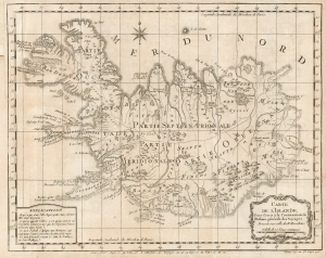
Carte de l'Islande, Pour servir a la Continuation de l'Histoire générale des Voyages.
$250.00
Acquire
- Digital Map Information
- Suitable for large format printing
- Full resolution TIFF file
- ICC color profile embedded
- Delivered instantly via download link
This is J. N. Bellin's 1768 edition of Niels Horrebow's map of Iceland, based on the first trigonometrical survey of the country. (more details)