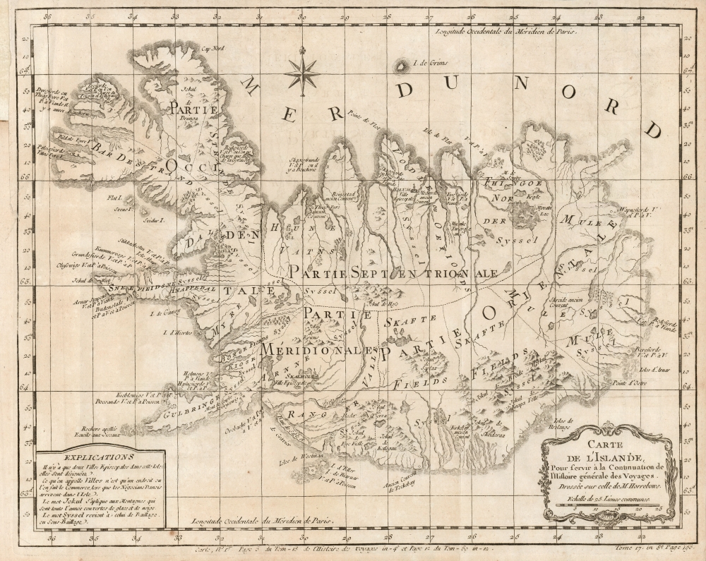
1768 Bellin / Horrebow / Knoff map of Iceland
Iceland-horrebow-1768$375.00

Title
Carte de l'Islande, Pour servir a la Continuation de l'Histoire générale des Voyages.
1768 (undated) 12 x 15 in (30.48 x 38.1 cm) 1 : 940000
1768 (undated) 12 x 15 in (30.48 x 38.1 cm) 1 : 940000
Description
This is J. N. Bellin's 1768 edition of Niels Horrebow's map of Iceland, based on the first trigonometrical survey of the country.
A Closer Look
The base survey was initiated by Magnús Arason in 1728. His 1730 death caused the work to be inherited by Norwegian officer Thomas Hans Henrik Knoff. Knoff completed the survey in 1734, correcting Arason's original. It was the first attempt to survey the island completely, rather than simply amending earlier maps. Knoff produced seven district maps and one map of the entire island. Unfortunately, since Iceland was a Danish possession, when Knoff's sent the maps to Norway, a power struggle followed. Knoff was ordered by the Danish king to return all copies and drafts, and so they did not see the light of day for several decades. In 1752, Niels Horrebow published Tilforladelige Efterretninger om Island (The Natural History of Iceland). It was accompanied by a map of Iceland based on Knoff, the use for which Horrebow obtained the king's permission. In this form, the map was considerably reduced, and its quality suffered from inexpert copper engraving, introducing errors. For example, despite being roughly correct in its location, the lake Myvatn is grossly overestimated in size. Despite the flaws, the map represents a vast improvement over the 16th-century publication of Bishop Guðbrand Þorláksson's map by Ortelius. Horrebow's printing of the Knoff data represented the first published trigonometrical survey of Iceland. Horrebow's book was published in a German edition in 1753, English in 1758, and French in 1764. The work appeared excerpted Prévost's Histoire Générale des Voyages, for which Bellin produced an edition of the map. This was added to Prévost in 1768.Publication History and Census
Bellin's map was engraved by for inclusion the 1768 first edition of the eighteenth volume of Prevost's Histoire Générale des Voyages. We are aware of two states of the map, the second of which includes in the lower right a pagination note for the map's inclusion in volume 17 of the octavo edition of the Histoire. The present example conforms to this second state, which seems to have appeared in 1780. The Histoire is well represented in institutional collections; the map is neglected in OCLC, appearing in only four listings, but it does appear on the market from time to time.CartographerS
Niels Horrebow (Septemner 17 1712 - May 20, 1760) was a Danish lawyer now known best for writing The Natural History of Iceland (Tilforladelige efterretninger om Island) in 1752. It was intended to correct errors in past natural histories of Iceland, whose authors had written about the island without ever visiting it. Horrebow lived there for two years, studying not only Iceland's animals, plants, weather, and geological features but also the cultural practices of the Icelandic people themselves. Horrebow was able to secure access to the previously suppressed 1734 Knoff map of Iceland, and his inclusion of a version of it in his work brought it to a wide audience. More by this mapmaker...
Jacques-Nicolas Bellin (1703 - March 21, 1772) was one of the most important cartographers of the 18th century. With a career spanning some 50 years, Bellin is best understood as geographe de cabinet and transitional mapmaker spanning the gap between 18th and early-19th century cartographic styles. His long career as Hydrographer and Ingénieur Hydrographe at the French Dépôt des cartes et plans de la Marine resulted in hundreds of high quality nautical charts of practically everywhere in the world. A true child of the Enlightenment Era, Bellin's work focuses on function and accuracy tending in the process to be less decorative than the earlier 17th and 18th century cartographic work. Unlike many of his contemporaries, Bellin was always careful to cite his references and his scholarly corpus consists of over 1400 articles on geography prepared for Diderot's Encyclopedie. Bellin, despite his extraordinary success, may not have enjoyed his work, which is described as "long, unpleasant, and hard." In addition to numerous maps and charts published during his lifetime, many of Bellin's maps were updated (or not) and published posthumously. He was succeeded as Ingénieur Hydrographe by his student, also a prolific and influential cartographer, Rigobert Bonne. Learn More...
Magnús Arason (1683 - 1728) was an Icelandic mathematician and cartographer. Having begun his studies in Iceland, he traveled to Copenhagen in 1705 to study engineering. He served as a military engineer under Peder Tordenskjold in the Great Northern War. In 1721, King Fredrik IV of Denmark sent him back to Iceland to survey and map both the land and the sea along the coast of his native country. He was the first to carry out accurate land measurements in Iceland. While engaged in surveying the coast, he died by drowning. Learn More...
Thomas Hans Henrik Knoff (January 31, 1699 - January 25, 1765) was a Norwegian army surveyor. Little is known of his education or service, prior to 1730 when he was sent to Iceland by the Danish government to continue and complete Magnús Arason's task of surveying the country. Knoff completed the work in 1734, but made the error of sending a copy of the map to a superior in Norway - an act that outraged his Danish employers. The Danish king stopped short of accusing Knoff with treason - which some had accused him of - but settled for suppressing the maps. These were declared state secrets by the Danish govenment until 1752, when they were provided to Danish scholar Niels Horrebow; through his work the map would be widely disseminated. Knoff's career did not end with the political kerfuffle: we see him engaged in surveys of the border of Norway and Sweden in 1742, Learn More...
Source
Prévost, A., Histoire Générale des Voyages, ou Nouvelle Collection de Toutes les Relations de Voyages par Mer et par Terre..., (Paris: Didot) 1746 - 1759, Supplements 1761 - 1801.
Prévost's Histoire Générale des Voyages is a 15-volume compendium of travel literature initiated by Antoine François Prévost (Provost; 1697 - 1763) in 1746, intended as a universal history of exploration and geography. The initial publication, compiled from 1746 to 1759, spans 15 volumes and draws from a vast array of sources - travelers, explorers, missionaries, merchants, and diplomats - to present detailed narratives of significant global journeys. The work was initially published in Paris by Didot and offers ethnographic, political, religious, and natural observations about the peoples, cultures, flora, fauna, and geography. It is an ambitious attempt to organize knowledge about the world's diversity according to Enlightenment values, reflecting both scientific curiosity and imperial ideology. It functioned as both an informative reference and a literary work, influencing how European audiences understood and imagined distant lands. It proved extremely successful, and both reissues other publishers and pirate editions emerged, most notably Pierre de Hondt's 1747 Dutch edition and Jean-Franćois de la Harpe's 1780 abridged version. In addition to reissues of the original work, between 1768 and 1801, additional expanded volumes emerged, adding new voyages and histories. We have seen some sets with as many as 80 volumes. Over time, the Histoire générale des voyages became one of the most comprehensive and widely read travel collections of the 18th century, notable for blending factual reporting with the period's characteristic intellectual ambition.
Condition
Very good. Margin extended at insertion point, else excellent.
References
OCLC 633106474.