
Astley, Thomas

Thomas Astley (died 1759) was a bookseller and publisher in London active predominantly between 1734 and 1747. His early history is a cipher and we know nothing of his education or training. He was a member of the Worshipful Company of Stationers, so there must have been an apprenticeship. Between 1727 and 1742 he printed and sold books from a Saint Paul's Churchyard address; starting in 1745 he sold his work from Paternoster Row. He is most remembered for his four-volume, 1745-48 Voyages and Travels which continued in the tradition of travel books by Hakluyt, Purchas, John Atkins, Jean Barbot, Willem Bosman, Theodor de Bry, Francis Moore, Jean-Baptiste Labat, Godefroi Loyer, Thomas Phillips, William Smith, and Nicolas Villaut de Bellefond - to the extent of recapitulating those earlier works. Astley's Voyages included maps engraved by George Child and Nathaniel Parr. Astley was an early publisher of the 'London Magazine,' founded in 1732 to compete with and oppose the Tory 'Gentlemen's political opposition and rivalry to the Tory 'Gentleman's Magazine.' Astley's publication in the magazine of the treason trial of the Jacobite Simon Lord Lovat led to Astley's arrest and punishment with fines (trials of peers in the House of Lords were meant to be secret). Though he regained his freedom upon his examination by the House of Lords (having pointed out that he was merely reprinting what had already been made public in the penny press) Astley was removed as publisher of the Magazine; there were no further volumes added to his Voyages and Travels. He died in 1759 survived by his wife and daughter (both named Susanna) who inherited his remaining stock and his pension from the Company of Stationers.
First Accurate English Map of Tibet.
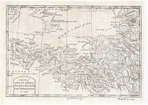
A Map of Great Tibet, drawn from that made by Lama Mathematicians in 1717.
$650.00
Acquire
- Digital Map Information
- Suitable for large format printing
- DPI: 600
- File Size: 9.69 MB
- File Type: ZIP / TIFF
- ICC color profile embedded
- Delivered instantly via download link
This is the earliest English map of Tibet, engraved for Braddock Mead's 1747 A New General Collection of Voyages and Travels, published under his pseudonym 'John Green' by Thomas Astley. It is one of the few maps of the region to rely (ultimately) on local sources - although the mapmaker's claim that the map was 'drawn from that made by Lama Mathematicians' does not include the chain of Jesuit missionaries and French cartographers linking the 'Lama Mathematicians' to the 'English engraver'. (more details)