This item has been sold, but you can get on the Waitlist to be notified if another example becomes available, or purchase a digital scan.
1747 Basire Map and Chart of Sierra Leone
SierraLeone-basire-1747$175.00

Title
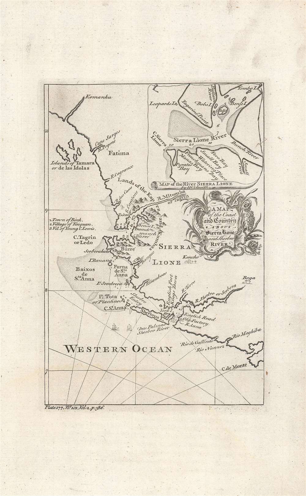
A map of the coast and country about Sierra Lione and Sherbro River.
1747 (undated) 8.75 x 6 in (22.225 x 15.24 cm) 1 : 1750000
1747 (undated) 8.75 x 6 in (22.225 x 15.24 cm) 1 : 1750000
Description
This is a c. 1747 map and chart of the coast of Sierra Leone most likely engraved by Isaac Basire for John Green's A New General Collection of Voyages and Travels, published between 1745 and 1747. Made during the height of the Transatlantic Slave Trade, this map depicts the major source of slaves bound for the British colonies in America.
The inset map also includes soundings, hazards, and anchorage points, while both the inset and main map indicate coastal sand banks. European knowledge of the interior remained quite limited, but some indigenous settlements and ethnic groups are noted and mapping of the Sierra Leone and Sherbro Rivers, where trade was most active, is quite detailed.
Bunce Island (here as 'Bense I.,'), located near the mouth of the Sierra Leone River, was a key node in the transatlantic slave trade to British colonies in North America, especially South Carolina and Georgia. It had been used by the English since the 1670s, when they built a castle and trading factory there. In the 1720s, José Lopez da Moura, a Luso-African slave trader, seized the island from the British but later abandoned it. Just prior to this map's publication, the island was acquired by Grant, Oswald and Company, which hired Henry Laurens, later President of the Continental Congress, as their business agent in Charleston, South Carolina.
A Closer Look
This map covers the West African coast from north of the Kaloum Peninsula and the Loos Islands (now Guinea) south to the Cape Mount Peninsula, in today's Liberia. The future site of Freetown, established in the 1790s, is located near center on the peninsula marked 'Bûrré.' Freetown Harbor, the largest and one of the best natural harbors in Africa, is dubbed 'Pyrates Bay' in the inset.The inset map also includes soundings, hazards, and anchorage points, while both the inset and main map indicate coastal sand banks. European knowledge of the interior remained quite limited, but some indigenous settlements and ethnic groups are noted and mapping of the Sierra Leone and Sherbro Rivers, where trade was most active, is quite detailed.
The Transatlantic Slave Trade
These coasts were first visited by Europeans when the Portuguese reached the area in the 1460s, after which they returned regularly to trade. Although slavery appears to have been a rare occurrence among the local tribes and kingdoms, strong economic incentives led to increased slave-raiding between groups. The Sierra Leone and Sherbro River were the main sites of trade with Europeans, which was dominated by the slave trade by the 18th century. The English had created a monopoly (the Royal African Company) to manage trade with this part of Africa, but it was supplanted in the early 18th century, creating a free-for-all among private traders that only increased the scale and brutality of the slave trade.Bunce Island (here as 'Bense I.,'), located near the mouth of the Sierra Leone River, was a key node in the transatlantic slave trade to British colonies in North America, especially South Carolina and Georgia. It had been used by the English since the 1670s, when they built a castle and trading factory there. In the 1720s, José Lopez da Moura, a Luso-African slave trader, seized the island from the British but later abandoned it. Just prior to this map's publication, the island was acquired by Grant, Oswald and Company, which hired Henry Laurens, later President of the Continental Congress, as their business agent in Charleston, South Carolina.
Publication History and Census
Although unattributed, this map most likely was engraved by Isaac Basire. It appeared in Volume II of John Green's A New General Collection of Voyages and Travels, printed in London by Thomas Astley between 1745 - 1747. The inset map is attributed to one 'Mr. Smith.' Earlier publication information at bottom-right looks to have been stricken from the plate, suggesting it had originally belonged to another engraver. The separate map is listed only once in the OCLC, at the National Library of Scotland, while the entire New General Collection is well represented in institutional collections.CartographerS
Isaac Basire (September 20, 1704 - August 24 1768) was a London engraver, first in a family line of prolific and well-respected engravers. His most well-known work is the frontispiece to an edition of Bailey's 1755 dictionary but he was primarily a map engraver. He was born in London to on J. Basire, a Huguenot emigre from Rouen. His son James (1730-1802), grandson James (1769-1822), and great-grandson James (1796-1869) all continued the family trade. Assigning specific works to particular members of the family is not a straightforward task, as all four Basires were engravers, one often as apprentice to his father. Thus the work of the four frequently overlapped. More by this mapmaker...
Thomas Astley (died 1759) was a bookseller and publisher in London active predominantly between 1734 and 1747. His early history is a cipher and we know nothing of his education or training. He was a member of the Worshipful Company of Stationers, so there must have been an apprenticeship. Between 1727 and 1742 he printed and sold books from a Saint Paul's Churchyard address; starting in 1745 he sold his work from Paternoster Row. He is most remembered for his four-volume, 1745-48 Voyages and Travels which continued in the tradition of travel books by Hakluyt, Purchas, John Atkins, Jean Barbot, Willem Bosman, Theodor de Bry, Francis Moore, Jean-Baptiste Labat, Godefroi Loyer, Thomas Phillips, William Smith, and Nicolas Villaut de Bellefond - to the extent of recapitulating those earlier works. Astley's Voyages included maps engraved by George Child and Nathaniel Parr. Astley was an early publisher of the 'London Magazine,' founded in 1732 to compete with and oppose the Tory 'Gentlemen's political opposition and rivalry to the Tory 'Gentleman's Magazine.' Astley's publication in the magazine of the treason trial of the Jacobite Simon Lord Lovat led to Astley's arrest and punishment with fines (trials of peers in the House of Lords were meant to be secret). Though he regained his freedom upon his examination by the House of Lords (having pointed out that he was merely reprinting what had already been made public in the penny press) Astley was removed as publisher of the Magazine; there were no further volumes added to his Voyages and Travels. He died in 1759 survived by his wife and daughter (both named Susanna) who inherited his remaining stock and his pension from the Company of Stationers. Learn More...
Source
Green, J. (Mead, Braddock), A New General Collection of Voyages and Travels, (London) 1747.
Condition
Excellent.
References
OCLC 698719288.