
Braeunlich, Gustav

Gustav Braeunlich (May 17, 1837 - January 15, 1923) was a German-Russian artist, lithographer, and engraver active in New York during the middle to late 19th century. Braeunlich was born in St. Petersburg, Russia and was of German-Saxon-Russian descent. His father was a Bishop in the Russian Orthodox Church. As a young man he served in the Russian army and saw action in the Crimean War. Census records suggest Braeunlich immigrated to the United States in 1860, settling in Brooklyn and studying art at Cooper Union, where he won several awards. It is not clear when he partnered with his younger cousin, Herman Braeunlich, to establish the engraving and lithographing firm G. Braeunlich and Co., but it was active from at least the 1862. The firm had multiple offices. The first may have been at 85 White Street, Brooklyn. In 1877 he was based at 58 Maiden Lane, Manhattan, where he shared the premises with cousin Herman Braeunlich (November 11, 1843 - August 3, 1916) and relative William Brauenlich. The firm relocated to 39 West Broadway in 1880. During his most active period Braeunlich engraved maps for John B Holmes, Tobacco Revenue stamps for the U.S. Treasury Department, and presidential campaign materials for Samuel Tilden. Braeunlich and his family, including Herman, lived in the same residence at 250 East 73rd at 3rd Ave, Brooklyn. Their name alternatively appears as 'Braunlich' and 'Breunlich'. After Gustav retired Herman maintained the business until at least 1910 from 86th Fulton Street, Manhattan. Gustav was the nephew of an important Brooklyn physician of the same name.
One of the earliest speciic maps to detail Manhattan Valley and the northern part of the Upper West Side.
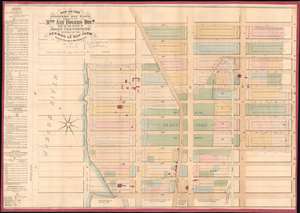
Map of the Strikers Bay Farm Estate of Mrs. Ann Rogers Decd. Part of the estate of John Glendining and part of the Herman Le Roy Farm.
$3,800.00
Acquire
- Digital Map Information
- Suitable for large format printing
- File Size: 27.98 MB
- File Type: ZIP / TIFF
- ICC color profile embedded
- Delivered instantly via download link
One of only 5 known examples of John Bute Holmes's c. 1874 cadastral map of the northern part of the Upper West Side and Manhattan Valley, New York City. The map covers from 96th street to 107th street and from the Hudson River to Central Park (8th Avenue / Central Park West). Today, with its proximity to both Riverside Park and Central Park, this is one of Manhattan's most desirable neighborhoods. (more details)