1867 Holmes Map of the Upper West Side and Manhattan Valley, New York City
1-StrikersBayRogers-holmes-1867$3,800.00

Title
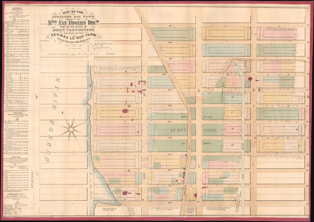
Map of the Strikers Bay Farm Estate of Mrs. Ann Rogers Decd. Part of the estate of John Glendining and part of the Herman Le Roy Farm.
1867 (undated) 24 x 34 in (60.96 x 86.36 cm) 1 : 1866
1867 (undated) 24 x 34 in (60.96 x 86.36 cm) 1 : 1866
Description
One of only 5 known examples of John Bute Holmes's c. 1874 cadastral map of the northern part of the Upper West Side and Manhattan Valley, New York City. The map covers from 96th street to 107th street and from the Hudson River to Central Park (8th Avenue / Central Park West). Today, with its proximity to both Riverside Park and Central Park, this is one of Manhattan's most desirable neighborhoods.
Holmes became fascinated by the early history of Manhattan real estate ownership, recognizing the wealth to be accrued by accurately understanding the history of city land ownership, division, and inheritance. Moreover, Holmes allied himself with the corrupt Tweed administration, assuring himself and his allies even greater wealth and political power from the eminent domain seizure of old Manhattan estates. Holmes created a series of maps, reminiscent of John Randall's 'Farm Maps', overlaid with property data, showing the borders of old estates, and notating the breakup of the lands among various heirs. The complex work of compiling the maps earned Holmes a fortune, with one newspaper suggesting on his death in 1887 that some of his individual maps were worth more than 30,000 USD. There is no complete carto-bibliography of Holmes' maps, but we believe there to be at least 50 maps, possibly more.
A Closer Look
This map is a cadastral map, that is, a map illustrating property lines and lots. It employs color coding, overprinting, and an alpha numeric system, to identify both old property lines dating to the earliest days of Manhattan's development and modern street grid and property lines compliant with the 1811 Commissioner's Plan. Old gentlemanly estates, most overlooking the Hudson, appear in red - these belonged with wealthy families, most of Dutch and English descent, who owed much of this land, among them Strikers, Rogers, Glendining, and Le Roy. Modern day Broadway, also called Bloomingdale Road, winds its way from north to south, as does the course of the Croton Aqueduct. Proposed expansions, including property lots, extend well into the Hudson River. To the left of the map, a long list of deeds and conveyances breaks down the real estate history of the area.Holmes' 'Farm Maps'
In the early 19th century most of Manhattan was undeveloped farmlands, the property of wealthy landowners with claims dating to the Dutch period of New York's history. The northern 2/3rd Manhattan was dotted with farmlands and sprawling gentlemanly estates, many with great manor houses overlooking the Hudson River. The Commissioner's Plan of 1811 and the 1807 Commission Law, laid the street grid through many of these properties and gave the city the right to claim these lands under eminent domain, providing due compensation to the landowners. While this work occurred early in lower Manhattan, central and upper Manhattan were not formally acquired by the city until the mid-19th century.Holmes became fascinated by the early history of Manhattan real estate ownership, recognizing the wealth to be accrued by accurately understanding the history of city land ownership, division, and inheritance. Moreover, Holmes allied himself with the corrupt Tweed administration, assuring himself and his allies even greater wealth and political power from the eminent domain seizure of old Manhattan estates. Holmes created a series of maps, reminiscent of John Randall's 'Farm Maps', overlaid with property data, showing the borders of old estates, and notating the breakup of the lands among various heirs. The complex work of compiling the maps earned Holmes a fortune, with one newspaper suggesting on his death in 1887 that some of his individual maps were worth more than 30,000 USD. There is no complete carto-bibliography of Holmes' maps, but we believe there to be at least 50 maps, possibly more.
Publication History and Census
This map was published by John Bute Holmes sometime between 1867 and 1872, probably on the earlier side. It was engraved and lithographed by the firm of Gustav Braeunlich and Co., who were located at 85 White Street during this period. There is only one edition. Holmes' cadastral maps are today all extremely rare. Of the present map, only three examples are cited in the OCLC with Stanford and the NYPL possibly holding a fourth and fifth.CartographerS
John Bute Holmes (March 31, 1822 - May 21, 1887) was an Irish civil engineer, city surveyor, and mapmaker based in New York City in the middle to latter 19th century. Holmes was described as a 'short, stout man, with curly gray hair, a smooth face, and a short, thick neck.' Holmes' father-in-law supplied funds for him to immigrate to America in 1840 and shortly thereafter, in 1844, he established himself in New York City. He briefly returned to Europe before once again settling in New York City in 1848. Apparently, according to several New York Times articles dating to the 1870s, Holmes was a man of dubious personal and moral character. He was involved in several legal disputes most of which were associated with his outrageous - even by modern standards - womanizing. In 1857 he was convicted of forgery of a marriage document and sentenced to 15 years of hard labor at Sing Sing, of which he served 5 before wealthy associates interceded on his behalf for an early release. Holmes seems to have been married to several different women at the same time and to have had an unfortunate attraction to exceptionally young women - one of whom, 16 year old May Chamberlayne claimed to be his wife and sued him for 50,000 USD. On another occasion he was found guilty of killing Brooklyn policeman David Gourly with whose wife he 'had been intimate.' Another woman, Miss Abrams, who he hired as a housekeeper, was repeatedly attacked by Holmes and ultimately driven to madness and was consigned to Bellevue Hospital, where she died. Although he attempted to flee the country rather than face conviction for 4th degree manslaughter, he was ultimately arrested and served one year in prison. During the American Civil War he ran for Alderman of the First Ward, in New York. Despite his legal issues, Holmes was a man of considerable means, with a personal fortune estimated between 100,000 and 500,000 USD - a significant sum in the late 19th century. Much of his wealth is associated with a series of important cadastral maps produced between 1867 and 1875 while he was employed as a surveyor and civil engineer under the corrupt Tweed regime. When Holmes died of an 'apoplectic fit' there was considerable wrangling over his estate among his 7 heirs and 11 children. The cream of his estate where his maps, some of which were valued at more than 30,000 USD in 1887. Holmes lived on a large farm-estate in Fanwood New Jersey. More by this mapmaker...
Gustav Braeunlich (May 17, 1837 - January 15, 1923) was a German-Russian artist, lithographer, and engraver active in New York during the middle to late 19th century. Braeunlich was born in St. Petersburg, Russia and was of German-Saxon-Russian descent. His father was a Bishop in the Russian Orthodox Church. As a young man he served in the Russian army and saw action in the Crimean War. Census records suggest Braeunlich immigrated to the United States in 1860, settling in Brooklyn and studying art at Cooper Union, where he won several awards. It is not clear when he partnered with his younger cousin, Herman Braeunlich, to establish the engraving and lithographing firm G. Braeunlich and Co., but it was active from at least the 1862. The firm had multiple offices. The first may have been at 85 White Street, Brooklyn. In 1877 he was based at 58 Maiden Lane, Manhattan, where he shared the premises with cousin Herman Braeunlich (November 11, 1843 - August 3, 1916) and relative William Brauenlich. The firm relocated to 39 West Broadway in 1880. During his most active period Braeunlich engraved maps for John B Holmes, Tobacco Revenue stamps for the U.S. Treasury Department, and presidential campaign materials for Samuel Tilden. Braeunlich and his family, including Herman, lived in the same residence at 250 East 73rd at 3rd Ave, Brooklyn. Their name alternatively appears as 'Braunlich' and 'Breunlich'. After Gustav retired Herman maintained the business until at least 1910 from 86th Fulton Street, Manhattan. Gustav was the nephew of an important Brooklyn physician of the same name. Learn More...
Condition
Very good. Relined with fresh linen. Surface abrasion and repaired splits.
References
OCLC 50558352.