
Browne, Christopher

Christopher Browne (fl. c. 1688 – 1712) was a British map seller, book seller, and publisher active in the late 17th and early 18th centuries. Browne apprenticed with Robert Walton whose business he took over in 1688. Little is known of Browne's life but he issued several maps in concert with the Overtons, Herman Moll, and Robert Morden. Brown appears to have retired in 1712, relocating to Chilthorne Domer, a picturesque village in Somerset, England. According to Worms and Baynton-Williams he was still alive as of 1737.
Exceptional separate issue propaganda map promoting British interests during King William's War.
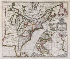
A New Map of the English Empire in America viz Virginia, New York, Maryland, New Jersey, Carolina, New England, Pennsylvania, New England, Pennsylvania, New Foundland, New France etc.
$17,000.00
Acquire
- Digital Map Information
- Suitable for large format printing
- Full resolution TIFF file
- ICC color profile embedded
- Delivered instantly via download link
An important and extremely rare separately issued c. 1695 map of the eastern part of North America by Robert Morden and Christopher Browne. Centered on the eastern Great Lakes, this map covers from the Mississippi River Valley to the Grand Banks and Newfoundland ... (more details)