
Bryant y Galiano, Tomás

Tomás Bryant y Galiano (fl. c. 1858 – 1879) was a Spanish navigator, sea captain, and chart maker active in the second half of the 19th century. Little is known of Bryant's life, but he appears to have been the grandson of a prominent Spanish shipbuilder Eduardo Bryant and son of Tomás Bryant y Smith (1748 – 18??). Bryant is best known for his charts of Spanish-American waters in the Caribbean and South America published by the Dirección de Hidrografía.
Charting Florida.
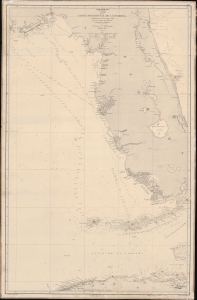
Seno Mejicano. Carta de la Costa Occidental de la Florida y Parte de La Isla de Cuba segun los trabajos mas modernos nacionales y estrangeros.
$950.00
Acquire
- Digital Map Information
- Suitable for large format printing
- Full resolution TIFF file
- ICC color profile embedded
- Delivered instantly via download link
A scarce 1866 working Spanish Dirección de Hidrografía nautical map of peninsular Florida and northern Cuba. This chart was used by the Santiago, one of the first steamships to ply the Havana-Cadiz route. (more details)