This item has been sold, but you can get on the Waitlist to be notified if another example becomes available, or purchase a digital scan.
1869 Direccion Hidrografía Map of South China Sea - Hong Kong to Hainan
Hainan-direccionhidrografia-1869$900.00

Title
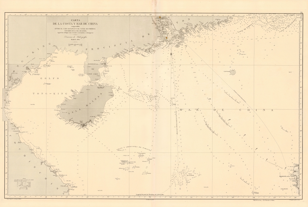
Carta de la Costa y Mar de China comprendida entre el Cabo Batangan y el Canal de Formosa con parte de la Isla de Luzon, segun los trabajos mas recientes macionales y estrangeros.
1869 (dated) 26 x 39 in (66.04 x 99.06 cm) 1 : 1580000
1869 (dated) 26 x 39 in (66.04 x 99.06 cm) 1 : 1580000
Description
A rare 1869 Direccion Hidrografía nautical map detailing the China coast and the South China Sea from, roughly, Hong Kong and Macao south to Hue (Vietnam) and Luzon (the Philippines), thus embracing a highly-trafficked and critical trade and strategic channel in the 19th century (as today). The map focuses heavily on coastal maritime routes, but pushes inland along major river arteries, including a detailed mapping of the Pearl River Delta as far as Canton (Guangzhou). In Vietnam, several factorias antiguas are noted, underscoring early European trade activity.
Historical Context
The end of the Second Opium War (1856 - 1860) was followed by nearly 80 years of relative peace and prosperity in East Asia. The Opium Wars forced Qing China to offer even greater territorial and trade concessions to western powers. Important ports like Hong Kong, Shanghai, and Singapore grew into major international cities, the hubs of vast trade networks extending throughout Asia and the world. This Spanish chart is particularly well designed to facilitate the important Hong Kong - Manila route, a vital artery for Spanish goods crossing the Pacific. This map is also significant for its illustration of the Hong Kong - Singapore route - an important nautical artery for trade in the Malacca Straits, and on to ports in India and ultimately, Europe.Hong Kong on this Map
Hong Kong appears in the upper right, intentionally at the northernmost limit of coverage. Both Hong Kong Island and the still small city of Victoria are named, as are the surrounding islands of Lamma and Lantau. The map notes a major lighthouse in nearby Macao - an important port for Spanish mariners since the 16th century. Near Hong Kong, the Pearl River Delta routes to Canton / Guangzhou are illustrated in detail.The Disputed Paracels
This map prominently illustrates the disputed Paracel Islands, located between China, Vietnam, and Taiwan - as presented here quite centrally. On an important maritime route, the Paracel Islands drew significant attention from early hydrographers. At the time little more than rocky shoals, the Paracels presented a considerable danger to regional navigation, as well as potential places of refuge against sudden storms. Nonetheless, until the 20th century, they were considered uninhabitable and so of little political interest, with several countries claiming sovereignty, but none enforcing it. In current times, the islands have taken on international significance due to the discovery of oil in the region and their strategic location. China, Vietnam, and Taiwan all claim de jure sovereignty, but the islands are under China's de facto control. China has since developed several of the islands, reclaiming significant acreage and constructing airstrips and deepwater ports.Publication History and Census
This map was drawn by Tomás Bryant y Galiano and engraved by Ramón Alabern Y Moles (map) and Francisco Bregante y Orbay (text). It was issued by the Direccion Hidrografía, a Spanish governmental nautical agency akin to the British Admiralty or U.S. Coast Survey. It was first published in 1862, with updates in 1867, and as here 1869. The map is scarce, but we are aware of examples at the British Library and the National Library of Spain.CartographerS
The Direccion Hidrografía (1787 - 1927), also known as the Deposito Hydrografico and the Direction de Hidrografía, was the Spanish equivalent of the British Admiralty or the U.S. Coast Survey. This organization, founded in 1787, was commissioned to collect and produce accurate nautical charts of all waters frequented by Spanish vessels. In essence, it replaced the Casa de la Contratación de las Indias (House of Trade of the Indies), which closed its doors in 1790. Like most such organizations, the Direccion Hidrografía marked a new age in cartography. Rather than simply collect charts created by navigators, explorers, and merchants, the Direccion Hidrografía worked closely with naval and military personnel to mount cartographic and hydrographic expeditions in pursuit of the most accurate hydrographical, astronomical, and geodetic measurements. The Direccion Hidrografía created a massive library of nautical charts that, though not nearly as common as similar nautical charts by the U.S. Coast Survey and British Admiralty, are highly desirable for the beauty of their manufacture as well as their accuracy and detail. The office was originally located on Calle Ballesta, but relocated to 36 Alcala, both in Madrid. After 1908 the Dirección was subsumed into other governmental agencies. In 1927 the Direccion was absorbed into the Institute and Observatory of San Fernando, located in Cadiz. The library of original maps, charts, and journals was transferred to the Naval Museum of Madrid - where it resides to this day. More by this mapmaker...
Tomás Bryant y Galiano (fl. c. 1858 – 1879) was a Spanish navigator, sea captain, and chart maker active in the second half of the 19th century. Little is known of Bryant's life, but he appears to have been the grandson of a prominent Spanish shipbuilder Eduardo Bryant and son of Tomás Bryant y Smith (1748 – 18??). Bryant is best known for his charts of Spanish-American waters in the Caribbean and South America published by the Dirección de Hidrografía. Learn More...
Ramón Alabern Y Moles (December 18, 1811 - 1888) was a Catalan map engraver active in Madrid and Barcelona in the early to mid-19th century. Ramón was born in Begues, just outside Barcelona, and initially studied engraving under his older brother, Pablo Alabern Y Moles (1804 - 1860). He afterward traveled to Paris to master to most sophisticated map engraving techniques. There he learnt the daguerreotyping, an early photographic technique, under the technique's inventor, Louis Jacques Mandé Daguerre (1787 - 1851). Returning to Barcelona in 1839, he introduced daguerreotyping to Spain with a dramatic presentation in partnership with the Real Academia de Ciencias Exactas, Físicas y Naturales. Throughout his career, Ramón supplemented his income as a map engraver for the Direccion Hidrografía with photography, publishing several daguerreotype compilations. Alabern died in Madried in 1888. Learn More...
Francisco Bregante y Orbay (fl. 1840 - 1867) was a Spanish engraver and draftsman active with the Dirección Hidrografía in the middle part of the 19th century. Bregante y Orbay specialized in lettering and text. A relative, Salvador Bregante y Orbay, also worked for the Dirección Hidrografía in a related capacity. Learn More...
Condition
Very good. Slight discoloration on centerfold.
References
OCLC 1039995003.