
Charpentier, Pierre-Henri

Pierre-Henri Charpentier (March 6, 1771 - December 25, 1854) was a French lithographer, engraver, printer, and editor. Born in Châlons-en-Champagne, Charpentier opened his lithography studio in Nantes at 32 Quai de la Fosse after receiving his lithographer's brevet. From the start, he worked with his son Henri-Désiré Charpentier (January 18, 1806 - June 29, 1882) and with his daughter Henriette (b. 1804). He received his printer's brevet in 1847, and in 1850 opened a studio in Paris on the Place Dauphine, which his son managed. One of his most celebrated publications was a set of lithographs of Breton costumes.
Symbolic geography - the Stations of the Cross.
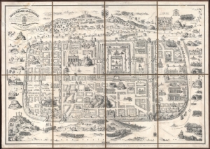
Plan de Jérusalem et de ses Faubourgs telle que cette ville célèbre existait du tems de Jésus-Christ, d'Après les Historiens sacrés et profanes...
$1,000.00
Acquire
- Digital Map Information
- Suitable for large format printing
- File Size: 87.69 MB
- File Type: ZIP / TIFF
- ICC color profile embedded
- Delivered instantly via download link
This is an 1840 Delahaye, Charpentier, and Dupuis plan of Biblical Jerusalem on the 16th-century Christian Adrichem model. Although the city, as depicted, is largely symbolic, the map highlights hundreds of sites within Biblical Jerusalem, allowing readers to follow biblical events cartographically. (more details)