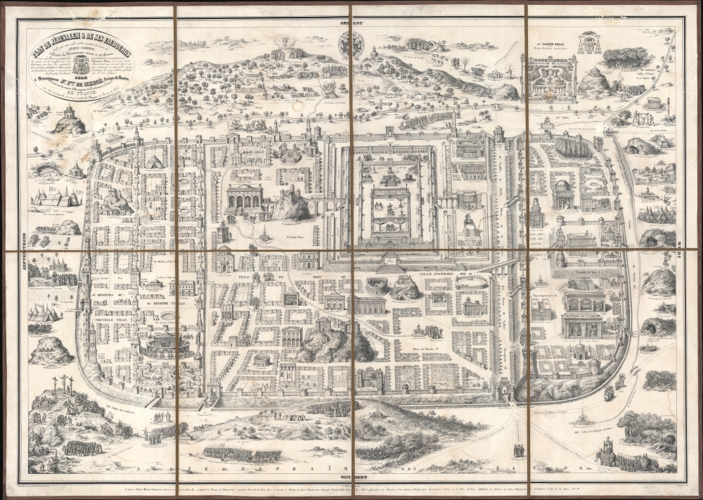
1840 Delahaye, Charpentier, and Dupuis Plan of Biblical Jerusalem
PlanJerusalem-delahaye-1840$1,000.00


Title
Plan de Jérusalem et de ses Faubourgs telle que cette ville célèbre existait du tems de Jésus-Christ, d'Après les Historiens sacrés et profanes...
1840 (dated) 30.75 x 43 in (78.105 x 109.22 cm)
1840 (dated) 30.75 x 43 in (78.105 x 109.22 cm)
Description
This is an 1840 Delahaye, Charpentier, and Dupuis plan of Biblical Jerusalem on the 16th-century Christian Adrichem model. Although the city, as depicted, is largely symbolic, the map highlights hundreds of sites within Biblical Jerusalem, allowing readers to follow biblical events cartographically.
A Closer Look
Based on the influential 1584 plan of Biblical Jerusalem by Christian van Adrichem (1533 - 1585), this work highlights 270 indexed locations. A plan of the Temple of Solomon appears to the right of center, with other sites scattered throughout. Biblical events, such as several battles fought by King David, the entrance of Jesus Christ into the city, and the Crucifixion, are illustrated.Stations of the Cross
As with Adrichem's plan, the present work depicts Christian veneration of the Holy City, in particular the Stations of the Cross. Since the Middle Ages, Catholic practice had incorporated the reenactment by the faithful of the Via Dolorosa, the route followed by Jesus on the day of Crucifixion. Pilgrims to Jerusalem would follow the route through the Holy Land, but with the expansion of the Turkish Empire, access to Jerusalem was strictly curtailed. European Christian cities began to assemble pilgrimage routes locally to allow pilgrims to follow a metaphorical Via Dolorosa without dangerous travel to distant lands. Churches and cathedrals would illustrate the Stations of the Cross - the different scenes along the Via Dolorosa - in their architecture and decoration. Adrichem's text and plan of Jerusalem provided a model that all could follow and that the faithful could practice, even from the comfort of home, in a 'Pilgrimage of the Mind'.Publication History and Census
This map was drawn by C. Delahaye and engraved and printed by Pierre-Henri Charpentier for Abbot André Dupuis. There were at least three editions. The first was published in Nantes in 1840, the second in Paris in 1841, and the third in Brussels in 1844. We note three examples of the present 1840 edition in OCLC: Leiden University, Maastricht University, and the Bayerische Staatsbibilothek. This map is rare on the private market, appearing only a handful of times in the last two decades.Cartographer
Pierre-Henri Charpentier (March 6, 1771 - December 25, 1854) was a French lithographer, engraver, printer, and editor. Born in Châlons-en-Champagne, Charpentier opened his lithography studio in Nantes at 32 Quai de la Fosse after receiving his lithographer's brevet. From the start, he worked with his son Henri-Désiré Charpentier (January 18, 1806 - June 29, 1882) and with his daughter Henriette (b. 1804). He received his printer's brevet in 1847, and in 1850 opened a studio in Paris on the Place Dauphine, which his son managed. One of his most celebrated publications was a set of lithographs of Breton costumes. More by this mapmaker...
Condition
Fair. Dissected and mounted on linen. Areas of upper right quadrant repaired, including title cartouche. Some scuffing. Some loss to upper right quadrant just below the Temple de Chamos. Areas of soiling and dampstaining.
References
OCLC 71416889, 165563629.