
Chéreau, Jacques (Chéreau le Jeune, Chereau the Younger)

Jacques Chéreau (Chéreau le Jeune, Chereau the Younger; October 29, 1688 - December 1, 1776) was a French engraver and printmaker. His often signed his work as Chéreau le Jeune to distinguish himself from his older brother, also a prominent engraver, François Chéreau I (1680 - 1729). Jacques learnt engraving under his brother before studying under Gérard Audran (1640 - 1703). He also lived for a time in London where he learnt how to engrave optical views, for which his firm later became known. Chéreau set up shop at Rue Saint-Jacques, Paris, a well-established center of engraving. His second marriage, to Marguerite-Geneviève Chiquet (17?? - 1773) in 1724, connected him to the firm of engraver and printseller Jacques Chiquet (1673 - 1721), whose workshop and plates he inherited in 1741. His daughter with Marguerite-Geneviève Chiquet was Geneviève-Marguerite Chéreau (17?? - 1782), who married her cousin François Chéreau II (1717 - 1755), son of François Chéreau I (1680 - 1729). After his death, Geneviève-Marguerite continued to run the business, engraving and publishing as Veuve Chéreau (Widow Chéreau, note there are two other later Veuve Chéreaus within the same family). She likely remarried into the Basset family, the beginning of a long series of incestuous intermarriages between the Chéreau and Basset clans intended to keep the flourishing business in the family. The family connections and overlaps are near impossible to unwind.
AKA: Chéreau le Jeune, Chereau the Younger
First published image of New Orleans.
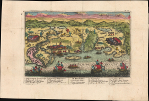
Le Mississipi ou la Louisiane dans l'Amerique Septentrionale.
$9,500.00
Acquire
- Digital Map Information
- Suitable for large format printing
- Full resolution TIFF file
- ICC color profile embedded
- Delivered instantly via download link
This is a rare c. 1720 Chéreau broadside leaflet map-view of the Gulf of Mexico littoral, just a few years after New Orleans was founded. It is likely the earliest printed view of New Orleans - though admittedly, it is not an accurate representation of the city at the time. The map was issued as a propaganda leaflet to promote New Orleans and French Louisiana, and thus coverage extends east to encompass most of the Florida Panhandle. It is among the earliest maps to include a view of New Orleans and the indigenous peoples of the Gulf. The present example is the first state, with extraordinary period color. (more details)