1720 / 1770 Chéreau / Basset Map of the Gulf Littoral and New Orleans - 1st View of New Orleans
MississippiFlorida-chereau-1779$7,500.00

Title
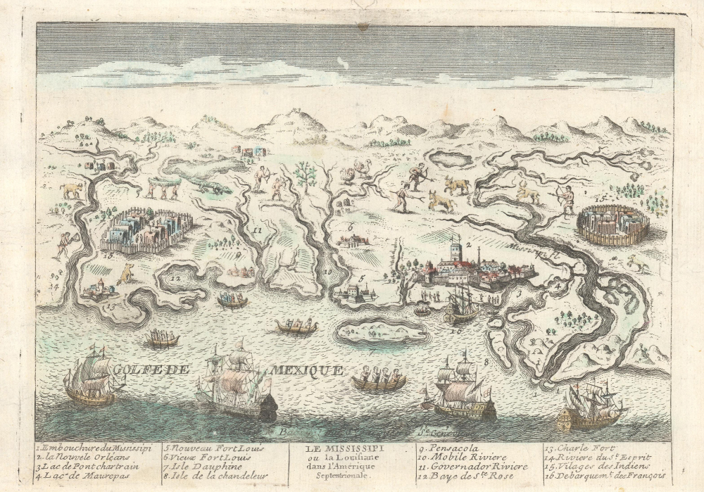
Le Mississipi ou la Louisiane dans l'Amerique Septentrionale.
1779 (undated) 7.25 x 10.5 in (18.415 x 26.67 cm)
1779 (undated) 7.25 x 10.5 in (18.415 x 26.67 cm)
Description
This is a rare c. 1779 Basset / Chéreau broadside leaflet map-view of the Gulf of Mexico littoral c. 1720, just a few years after New Orleans was founded. It is likely the earliest printed view of New Orleans - though admittedly, it is not an accurate representation of the city at the time. The map was issued as a propaganda leaflet to promote New Orleans and French Louisiana. It is indeed one of the earliest maps to include a view of New Orleans and the indigenous peoples of the Gulf. The present example is the second state, issued in late 1770s by Basset to capitalize on French public interest in the American Revolutionary War (1775 - 1783).
The overall engraving is crude, reflecting the nature of this optic as a propaganda leaflet meant to be produced quickly and widely distributed freely or at low cost. Such objects, as here, tend to have extremely low survival rates.
A Closer Look
The view takes a mirrored perspective on the coast; it is oriented to the north, but west is on the right, and east is on the left. Coverage extends from the Mississippi, identified at the far right, to just beyond modern-day Choctawatchee Bay, identified here as Baye de Ste. Rose. The whole is vague and imprecise, reflecting the limited knowledge of this coastline and the interior. The comparative size of the French city of New Orleans and the two American Indian cities underscores major centers with dense populations. Cities identified are, from, roughly, left to right.- Embouchure du Missisipi - Mouth of the Mississippi River
- La Nouvelle Orleans - New Orleans, Louisiana
- Lac de Pontchartrain - Lake Pontchartrain
- Lac de Maurepas - Lake Maurepas
- Nouveau Fort Louis - Mobile, Alabama (1712 - Present)
- Vieux Fort Louis - Le Moyne, Alabama (fl. 1702 - 1712)
- Isle Dauphine - Dauphin Island
- Isle de la Chandeleur - Chandeleur Islands
- Pensacola - Pensacola, Florida
- Mobile Riviere - Mobile Bay
- Governador Riviere - Possibly the Blackwater River north of Mobile Bay
- Baye de Ste. Rose - Choctawhatchee Bay
- Charle Fort - Also known as Fort Charles (fl. 1696 - 1710)
- Riviere du St. Esprit - Possibly the Apalachicola River
- Villages des Indiens - Various American Indian settlements, some walled and apparently very large
- Débarquement des Français - Port of New Orleans
The overall engraving is crude, reflecting the nature of this optic as a propaganda leaflet meant to be produced quickly and widely distributed freely or at low cost. Such objects, as here, tend to have extremely low survival rates.
Scholarship
Cécile Vidal, in his excellent book Caribbean New Orleans Empire, Race, and the Making of a Slave Society, offers an insightful analysis of the image:…splendid engraving attributed to François Chéreau and dated circa 1720. Such images were used for propaganda purposes. Although only a few shacks had been erected at the time of Chéreau's engraving, the artist represented New Orleans as an imposing fortified city, with a majestic church, several monuments, and stone houses. The multiple ships cruising in the Gulf of Mexico and the Native American forts and villages scattered in the background recalled that 'the Mississippi' had been integrated within the French Empire through colonial expansion. The contrast between the indigenous wooden stockades and the stone walls surrounding the city, built in the manner of Sébastien Le Prestre de Vauban, materialized the colonial situation, that is the asymmetrical relationships in which the newcomers and First Nations were caught, and highlighted the difference that colonists thought existed between Europeans and Native Americans.Publication History and Census
This map was first issued c. 1720 by Jacques Chéreau (LOC 75693015), who signed the work 'Chéreau le Jeune'. There are two states, the 1720 Chéreau state and this later Basset variant. Both are separate plates, with the main difference being that the 1720 edition is oriented correctly with west at the left, while this edition is mirrored, with west at the right. All examples in all editions are extremely rare to the point of being unobtainable. Of this Basset edition, we note holdings at the Library of Congress, the Musée des Civilisations de l'Europe et de la Méditerranée, and the Historic New Orleans Collection.
CartographerS
André Basset (Bassett; fl. 1768 - 1784) was a well-known French publisher and engraver active on the Rue St. Jacques, Paris, during the 18th and 19th centuries. His office was located at the corner of Rue Saint Jacques and of Mathurins, à l'enseigne de Sainte Geneviève. The firm is closely aligned with the Chéreau family of printers and engravers, with whom they were connected with multiple, often incestuous, marriages and remarriages. Basset was best known for the production of low-cost optical views of European cities and events. However, the firm also produced games, maps, and other prints. The firm was taken over by Paul-André Bassett (1759 - 1829) in 1784. Paul-André Bassett himself retired in 1819, but the business continued under various family members until 1865. More by this mapmaker...
Jacques Chéreau (Chéreau le Jeune, Chereau the Younger; October 29, 1688 - December 1, 1776) was a French engraver and printmaker. His often signed his work as Chéreau le Jeune to distinguish himself from his older brother, also a prominent engraver, François Chéreau I (1680 - 1729). Jacques learnt engraving under his brother before studying under Gérard Audran (1640 - 1703). He also lived for a time in London where he learnt how to engrave optical views, for which his firm later became known. Chéreau set up shop at Rue Saint-Jacques, Paris, a well-established center of engraving. His second marriage, to Marguerite-Geneviève Chiquet (17?? - 1773) in 1724, connected him to the firm of engraver and printseller Jacques Chiquet (1673 - 1721), whose workshop and plates he inherited in 1741. His daughter with Marguerite-Geneviève Chiquet was Geneviève-Marguerite Chéreau (17?? - 1782), who married her cousin François Chéreau II (1717 - 1755), son of François Chéreau I (1680 - 1729). After his death, Geneviève-Marguerite continued to run the business, engraving and publishing as Veuve Chéreau (Widow Chéreau, note there are two other later Veuve Chéreaus within the same family). She likely remarried into the Basset family, the beginning of a long series of incestuous intermarriages between the Chéreau and Basset clans intended to keep the flourishing business in the family. The family connections and overlaps are near impossible to unwind. Learn More...
Condition
Good. Remnants of old color. A few minor verso repairs. Reinstated chip upper margin, outside of neatline.
References
Library of Congress, G3862.C6A35 177-.B3.