
Daly, Dominic Daniel

Dominic Daniel Daly (fl. c. 1874 - 1888) was a British surveyor and cartographer active in Australia, the Malay Peninsula, and Borneo in the late 19th century. Scottish by birth, he emigrated to South Australia where his uncle, Sir Dominick Daly, was governor, and worked as a surveyor on the Northern Territory Survey Expedition. Afterwards, he relocated to Singapore and then took up the office of Superintendent of Public Works and Surveys at Selangor. He travelled throughout the British territories as well as the 'native states' of the region. In addition to his surveying work, Daly published articles on the geology and speleology of the Malay Peninsula and Borneo.
Surveying the interior of the Malay Peninsula.
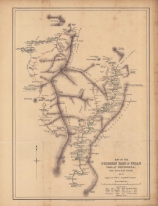
Map of the northern part of Perak (Malay Peninsula)...
$1,300.00
Acquire
- Digital Map Information
- Suitable for large format printing
- File Size: 12.31 MB
- File Type: ZIP / TIFF
- ICC color profile embedded
- Delivered instantly via download link
An early map of the northern part of the Perak Sultanate, now a state of Malaysia, prepared by pioneering British surveyor Dominic Daniel Daly for publication in the 1882 Proceedings of the Royal Geographical Society. It dates from soon after the establishment of a British residency in the sultanate, amid a tin mining boom that transformed the region's economy and society. (more details)
Expanding British influence in Malaya; early mention of Kuala Lumpur.
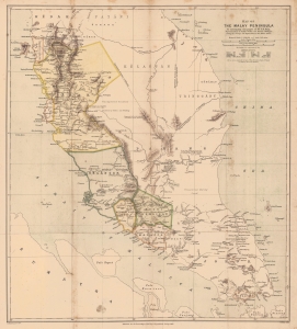
Map of the Malay Peninsula. To accompany the paper of Mr. D.D. Daly...
$1,100.00
Acquire
- Digital Map Information
- Suitable for large format printing
- File Size: 16.98 MB
- File Type: ZIP / TIFF
- ICC color profile embedded
- Delivered instantly via download link
An important map of the Malay Peninsula by Dominic Daniel Daly, lithographed by Edward Weller and published in 1882 in the Proceedings of the Royal Geographical Society. Daly's surveys of portions of the peninsula were the first scientific surveys conducted there. The map depicts the peninsula as British influence over the indigenous sultanates was expanding rapidly, aided by a boom in tin mining. (more details)