1882 Daly Map of Perak, Malay Peninsula
Perak-daly-1882$1,300.00

Title
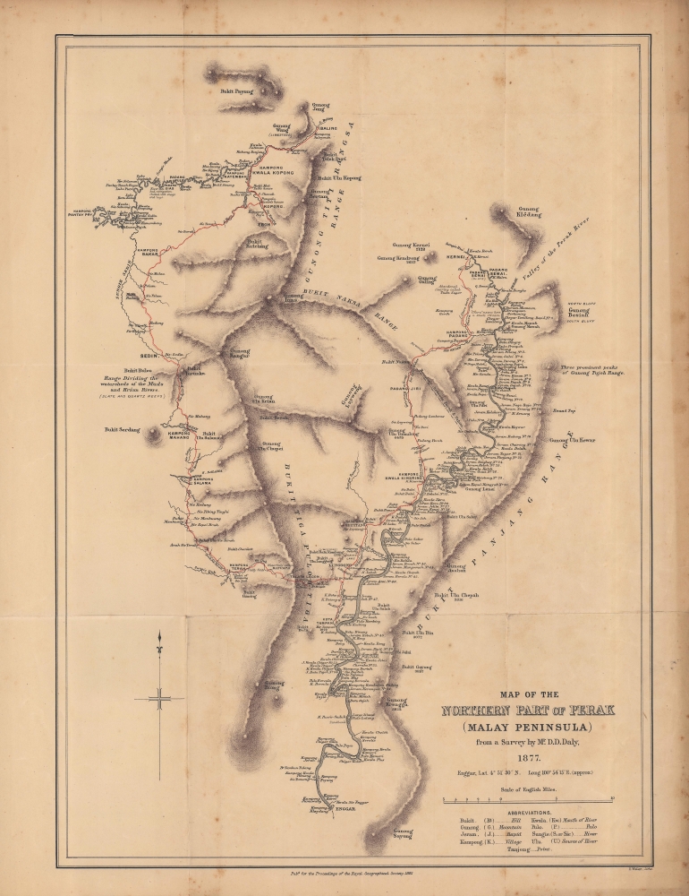
Map of the northern part of Perak (Malay Peninsula)...
1882 (dated) 18.5 x 13.25 in (46.99 x 33.655 cm) 1 : 250000
1882 (dated) 18.5 x 13.25 in (46.99 x 33.655 cm) 1 : 250000
Description
An early map of the northern part of the Perak Sultanate, now a state of Malaysia, prepared by pioneering British surveyor Dominic Daniel Daly for publication in the 1882 Proceedings of the Royal Geographical Society. It dates from soon after the establishment of a British residency in the sultanate, amid a tin mining boom that transformed the region's economy and society.
A Closer Look
Coverage includes roughly the northern half of Perak, bordered to the northwest by Kedah, to the north by Patani, and to the east by Kalantan. Large and small waterways are noted throughout, along with areas of elevation and settlements. Red lines trace Daly's route on his survey expeditions in the region. A table of abbreviations at bottom-right provides a brief glossary of Malay geographical terms. The Perak River runs along the right side of the map, from near the present-day border between Thailand and Malaysia at the Royal Belum State Park, down to Enggar (Enggor), today known as Karai, where a railway bridge across the Perak River was constructed in between 1897 and 1900.Tin Boom
As with Daly's other survey maps of Malaya, previous British geographic knowledge of these interior parts of Perak was limited. British involvement on the Malay Peninsula increased rapidly in the years just prior to this map's publication, as they sought to manage and profit from thriving tin mining. Like other Malay sultanates, the wealth created by the tin trade set off conflict within the Malay elite of Perak and among Chinese mining organizations which doubled as secret societies, and the British were able to suggest themselves as an intermediary to oversee and stabilize the situation. Thus, the Pangkor Treaty of 1874 allowed the British to establish a 'Resident' in Perak, which became a model for other Malay states and led, ultimately, to the creation of the Federation of Malay States in 1896.Publication History and Census
This map was lithographed by Edward Weller, based on an 1877 survey by Dominic Daniel Daly, for publication in the Proceedings of the Royal Geographical Society in 1882. It is independently cataloged among the holdings of the University of Chicago and the University of Wisconsin-Milwaukee, while Daly's accompanying article 'Surveys and explorations in the native states of the Malayan Peninsula 1875-82' is cataloged among the holdings of the National Library Board in Singapore and the National Library of Malaysia.CartographerS
Dominic Daniel Daly (fl. c. 1874 - 1888) was a British surveyor and cartographer active in Australia, the Malay Peninsula, and Borneo in the late 19th century. Scottish by birth, he emigrated to South Australia where his uncle, Sir Dominick Daly, was governor, and worked as a surveyor on the Northern Territory Survey Expedition. Afterwards, he relocated to Singapore and then took up the office of Superintendent of Public Works and Surveys at Selangor. He travelled throughout the British territories as well as the 'native states' of the region. In addition to his surveying work, Daly published articles on the geology and speleology of the Malay Peninsula and Borneo. More by this mapmaker...
Edward Weller (July 1, 1819 - 1884) was a cartographer and engraver based in London. Weller was a nephew of another well-known map publisher Sidney Hall (1788 - 1831), who gave him 50 Pounds to pay his apprenticeship fees. He engraved for many prominent mapmakers and was active enough in the community to be recommended for membership to the Royal Geographical Society in 1851 on the recommendation of John Arrowsmith, among others. He eventually inherited the Sidney Hall map business which led him to follow Arrowsmith as the unofficial geographer to the Royal Geographical Society. Weller was among the first map printers in London to embrace lithography. His best known work appears in Cassell's Weekly Dispatch Atlas, published in monthly segments for subscribers of the 'Weekly Dispatch' newspaper. This collection of maps eventually grew to include much of the known world. Published in various editions from 1855 through the early 1880s. Weller died in May of 1884, leaving behind a successful business and an unhappy widow. His son, Francis Sidney Weller (1849 - 1910), followed in his father's footsteps and continued the family map business. The atlas Mackenzie's Comprehensive Gazetteer of England and Wales was published in 1894 and bore F. S. Weller's signature on the maps. Learn More...
Royal Geographical Society (fl. 1830 - present) is a British Society established in 1830 to promote geographical science and exploration. Originally titled the "Geographical Society of London", the RGS received its royal charter from Queen Victoria in 1859 shortly after absorbing several similar but more regional societies including the African Association, the Raleigh Club and the Palestine Association. The RGS sponsored many of the most important and exciting voyages of exploration ever undertaken, including the exploration of Charles Darwin, David Livingstone, Robert Falcon Scott, Richard F. Burton, John Speke, George Hayward, H. M Stanley, Ernest Shackleton and Sir Edmond Hillary. Today, the RGS remains a leading global sponsor of geographical and scientific studies. The Society is based in Lowther Lodge, South Kensington, London. Learn More...
Source
Daly, D.D., 'Surveys and Explorations in the Native States of the Malayan Peninsula, 1875-82' Proceedings of the Royal Geographical Society and Monthly Record of Geography, Vol. 4, No. 7 (Jul., 1882), pp. 393-412.
Condition
Good. Some wear along the fold lines and foxing in the margins.
References
OCLC 166884758, 961906314.