
Denver Lithographing Company

Denver Lithographing Company (fl. c. 1875 - 1925) was a late 19th and early 20th century printing and lithography firm active in Denver, Colorado. It was first named Charles S. Stone and Company, after its founder, but by 1876 was operating as the Denver Lithographing Company out of 389 Larmier Street. Co-owners included Richard P. Goddard and Edwin Wagner. The firm was an early adopter of chromolithography and uniquely produced some of the most dramatic early advertising images of the American west. We have been unable to discover more regarding the founders.
Pueblo - the Pittsburg of the West?
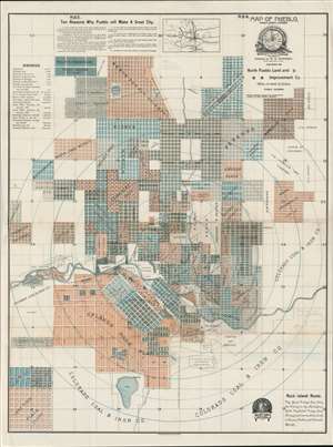
Map of Pueblo, Pueblo County, Colorado.
$4,000.00
Acquire
- Digital Map Information
- Suitable for large format printing
- File Size: 45.01 MB
- File Type: ZIP / TIFF
- ICC color profile embedded
- Delivered instantly via download link
A scarce 1888 map of Pueblo, Colorado, issued by W. H. Whitney. The map was issued at a heady time in Pueblo's development. Robust promotion, industrialization, and general regional prosperity led to rapid urbanization. The smaller towns of Pueblo (incorporated 1870), South Pueblo (incorporated 1873), and Central Pueblo (incorporated 1882) quickly grew into one another and legally consolidated as the City of Pueblo in 1886 - just two years before this map was issued. The present map is all about real-estate promotion, with developments named and color-coded, and individual blocks numbered where appropriate. (more details)
Mormon Pioneers and the Westward Expansion.
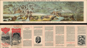
Route of the Mormon Pioneers from Nauvoo to Great Salt Lake.
$1,300.00
Acquire
- Digital Map Information
- Suitable for large format printing
- File Size: 43.98 MB
- File Type: ZIP / TIFF
- ICC color profile embedded
- Delivered instantly via download link
This is a beautiful 1899 chromolithograph panoramic bird-eye view map of the 1,300-mile Mormon Trail. It is one of the finest illustrations of the Mormon migration published - here in its smaller Wilson Hotel edition. (more details)