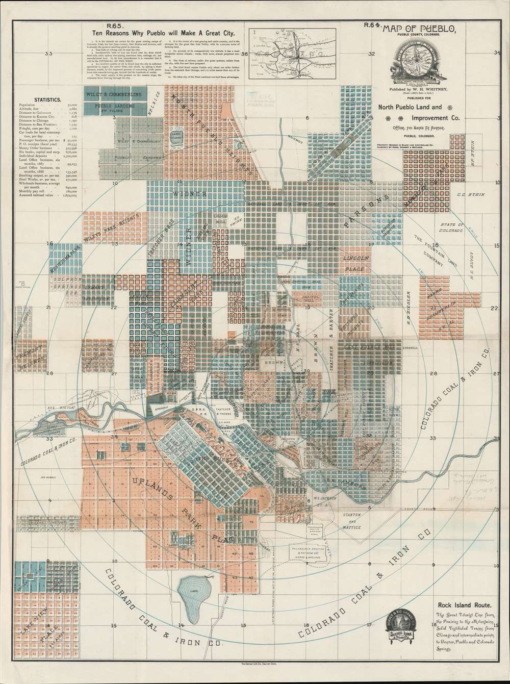
1888 Whitney Map of Pueblo, Colorado
PuebloColorado-whitney-1888$5,000.00

Title
Map of Pueblo, Pueblo County, Colorado.
1888 (dated) 34 x 24.25 in (86.36 x 61.595 cm) 1 : 20000
1888 (dated) 34 x 24.25 in (86.36 x 61.595 cm) 1 : 20000
Description
An extremely rare 1888 map of Pueblo, Colorado, issued by W. H. Whitney. The map was issued at a heady time in Pueblo's development. Robust promotion, industrialization, and general regional prosperity led to rapid urbanization. The smaller towns of Pueblo (incorporated 1870), South Pueblo (incorporated 1873), and Central Pueblo (incorporated 1882) quickly grew into one-another and legally consolidated as the City of Pueblo in 1886 - just two years before this map was issued. The present map is all about real-estate promotion, with developments named and color-coded, and individual blocks numbered, where appropriate.
In the 1880s a Utah division spun off, building a narrow gage line to connect Salt Lake City with Grand Junction. In 1888, to raise money for upgrades, Palmer incorporated the Salt Lake - Ogden line as a new railroad, the Rio Grande Western. Since narrow gage tracks were laid in the early 1880s, the main goal was to widen the gage to connect more seamlessly with the existing DRG network. Funds raised, the RGW was consolidated with the DRG in 1889. Construction between November 1889 and June 1890 completed the upgrade.
These lines and others under the DRG banner fell into the hands of railroad tycoon George Jay Gould (1864 - 1923) in 1900-1901. Under Gould they formed the foundation of a transcontinental route, the Western Pacific. Conflict with the Union Pacific eventually pushed the railroad into financial hardship, but it nonetheless continued to operate through the 20th century. In 1996, it was finally acquired by the Union Pacific and remains in operation.
The Pittsburg of the West
As early 1881, Pueblo was also beginning to emerge as a steel town. The founding of Colorado Fuel and Iron, Massachusetts Smelting, and Philadelphia Smelting - all identified here - transformed Pueblo into the only steel town west of the Mississippi, earning it the moniker 'Pittsburg of the West'. The consolidated city grew in leaps and bounds as the steel mills demanded ever more workers. This also led to remarkable cultural diversity with, at one point, more than forty languages spoken in the steel mills and more than two-dozen foreign language newspapers.Denver Rio Grande Railroad
The Denver Rio Grande (DRG) was founded in 1870 by William Jackson Palmer (1836 - 1909). The proposed route was to proceed south from Denver an estimated 875 miles (1,408 km) to El Paso via Pueblo, the west along the Arkansas River, then through the San Luis Valley of Colorado toward the Rio Grande. Construction began in earnest, leading to a rivalry with the Atchison, Topeka and Santa Fe Railway. Legal arguments turned into the wild west style Colorado Railroad War (1877 - 1880), with both sides leveraging corrupt politicians and gunslinger gangs to defend their claims. Federal courts decided on behalf of the Denver and Rio Grande, ending the war between the railroads. The entrenched gunslingers in Pueblo (Bat Masterson and his gang) continued to fight, well, everyone.In the 1880s a Utah division spun off, building a narrow gage line to connect Salt Lake City with Grand Junction. In 1888, to raise money for upgrades, Palmer incorporated the Salt Lake - Ogden line as a new railroad, the Rio Grande Western. Since narrow gage tracks were laid in the early 1880s, the main goal was to widen the gage to connect more seamlessly with the existing DRG network. Funds raised, the RGW was consolidated with the DRG in 1889. Construction between November 1889 and June 1890 completed the upgrade.
These lines and others under the DRG banner fell into the hands of railroad tycoon George Jay Gould (1864 - 1923) in 1900-1901. Under Gould they formed the foundation of a transcontinental route, the Western Pacific. Conflict with the Union Pacific eventually pushed the railroad into financial hardship, but it nonetheless continued to operate through the 20th century. In 1996, it was finally acquired by the Union Pacific and remains in operation.
W. H. Whitney Maps
Between 1887 and 1888 W. H. Whitney issued a series of separate-issue large-scale pocket maps of western cities serviced by the Rio Grande Western Railroad. These are scarce and little known, but include maps of Pueblo, Trinidad, Salt Lake City and possibly elsewhere. Whitney did not survey the maps himself. Instead, they are based upon local railroad and real-estate survey work, which he compiled as a uniform whole. Most feature advertisements for real-estate development companies. In some cases, the same map was be issued multiple times with different promotions. All, however, bear the Rio Grande Western logo, suggesting that the railroad was underwriting their production. The Rio Grande Western series were all printed by Denver Lithography, and their distinctive clean lines, typography, and muted printed color informed all subsequent Whitney city plans. Whitney's work for the Rio Grande Western caught the attention of the Northern Pacific Railroad in 1889, and between 1889 and 1890 he issued similar maps of cities serviced by the Union Pacific and Northern Pacific Railroads. These include Salt Lake City, Portland, Seattle, Astoria, Spokane, Port Townsend, Bellingham Bay, and Tacoma. There may be others. Like his Colorado maps, these were underwritten by the Northern Pacific and all bear that firm's logo. The maps are copyrighted to 'W. H. Whitney', filed in Washington D.C. While we cannot be certain, we believe this to be the Boston civil engineer William Henry Whitney, who, after 1888, owned a private civil engineering, surveying, and mapmaking firm in Boston. While Whitney may not have considered the maps important, instead focusing on real-estate development in Boston, they are today one of his most significant legacies. Individually and collectively, they represent some of the earliest obtainable maps of their respective subjects, marking them as important historical records of the urbanization of the American west. Today, all such maps are extremely scarce.Publication History and Census
This map was published in Denver, Colorado, around 1888 by W. H. Whitney. It is one of three maps produced by Whitney for the DRG / RGW between 1888 and 1889 - the others being Salt Lake City and Trinidad. As far as we are aware, this is the only Whitney map not printed by Everts in Philadelphia, suggesting it may be his first. It was instead printed by the Denver Lithographing Company. We are aware of just four surviving examples, the present map, as well as examples at Yale, the Denver Public Library, and History Colorado.CartographerS
William Henry Whitney (January 3, 1843 - May 4, 1909) was an American civil engineer active in Boston in the second half of the 19th century. Whitney was born in Needham, Massachusetts. He studied at Cambridge High School then at the Lawrence Scientific School of Harvard University. In July of 1862, he enlisted in the Union Army to fight in the American Civil War (1861 - 1865). He served honorably throughout the war, seeing action and suffering wounds twice. He left the service with the rank of Brevet-Major. He served as Alderman of Cambridge. and was involved with the Back Bay development project - producing multiple maps and plans. He began his studies as a civil engineer before the war in the office of Stephen P. Fuller. From 1869 - 1871 he worked in the Boston City Engineer's Office and was involved with the Back Bay development project - producing multiple maps and plans. In 1872, he entered into partnership with J. Franklin Fuller, son of S. P. Fuller. After a short time, Fuller retired and Whitney took full control of the firm, in 1888 renaming it William H. Whitney. As a private contractor he continued to work on the Back Bay. Also around this time, he completed multiple plans for the official records of the Civil War. Between 1889 and 1890, he took a contract with the Union Pacific to produce a series of maps of western cities, including Portland, Salt Lake City, Seattle, Astoria, Port Townsend, Spokane, and more. While he did not consider them an important part of his corpus, they are today arguably his most significant works, being among the earliest obtainable plans of those cities. He was also influential in introducing blueprint technology to American architecture and engineering. More by this mapmaker...
Denver Lithographing Company (fl. c. 1875 - 1925) was a late 19th and early 20th century printing and lithography firm active in Denver, Colorado. It was first named Charles S. Stone and Company, after its founder, but by 1876 was operating as the Denver Lithographing Company out of 389 Larmier Street. Co-owners included Richard P. Goddard and Edwin Wagner. The firm was an early adopter of chromolithography and uniquely produced some of the most dramatic early advertising images of the American west. We have been unable to discover more regarding the founders. Learn More...
Condition
Very good. Minor restoration here and there along old fold lines.
References
OCLC 7458723.