
Engel, Samuel

Samuel Engel (1702 - 1784) was a Swiss geographer, agronomist, and mathematician active in the middle part of the 18th century. His main work, Memoires and Observations was published in 1765 and while somewhat obscure today was highly influential in the 1700s. Engel argued that ice only formed in fresh water and that, such being the case, the Arctic Ocean would be ice-free and navigable closer to the poles. Engel's theories influenced exploration in search of the Northwest Passage, and specifically the launching of the disastrous 1773 Phipps expedition to the North Pole. He also wrote several articles for Diderot's Encyclopedie, including a description of a pre-Columbian Chinese colony in North America - Fusang. Engel also argued that Baron Lahonton, an enigmatic explorer of America's inland waterways, was in fact fictitious - though he nonetheless incorporated Lahonton's geography in his own maps.
A Map of Many Firsts.
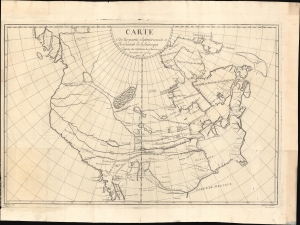
Carte du la Partie Septentrionale et Occidentale de l'Amerique d'apres les relations les plus recentes dresses en 1764 par M.
$4,500.00
Acquire
- Digital Map Information
- Suitable for large format printing
- DPI: 600
- File Size: 907.84 MB
- File Type: ZIP / TIFF
- ICC color profile embedded
- Delivered instantly via download link
This is an extremely scarce, influential, and often misunderstood map of North America published in 1765 by Samuel Engel. Engel composed this map to address and reconcile conflicting speculations regarding the American West and North Pacific - specifically the Buache-Delisle / Müller-Bering controversy. He compiled it from primary-source material, ranging from Lahonton's fictional expedition to the factual account of the American Indian voyager Moncacht-Apé. The latter led to Engel's mapping of the Columbia River - the first such map to do so based on actual observation. Although obscure today, Engel's work was well received when published. Thus, it provided source material for some of the most significant maps of the latter 18th century. (more details)